

NorthHillsWx
-
Posts
5,523 -
Joined
-
Last visited
Content Type
Profiles
Blogs
Forums
American Weather
Media Demo
Store
Gallery
Posts posted by NorthHillsWx
-
-
8 minutes ago, BornAgain13 said:
Around 7 AM Next Monday 12Z EURO
Sent from my SM-N981U using Tapatalk
Thing of beauty though temps are very marginal (850’s and Surface) but that’s also how we rip big dendrites and rates in the south
-
2 minutes ago, olafminesaw said:
I wouldn't call it cold chasing moisture necessarily (and all the issues that come along with that). It's just that the storm is too far north. A really good run though, with the way things had been trending.
Definitely nice having Dr. No in your court. Last 3 systems the Euro has said “Nope” and turned out correct. Key takeaway for me is there is consensus now across most modeling (Ukie, GFS and ensembles, CMC, Euro, ICON lol) that there will be a storm around that timeframe and there is some cold air to work with. Way too far for specifics but this is about as good agreement at this range as you’re gonna get
-
 1
1
-
-
5 minutes ago, stormtracker said:
is the SE forum hopping yet?
Nope, seems everyone has moved on to spring. Been getting my analysis from you all. Definitely one of the strongest storm signals of the season here and no one’s saying a word.
-
I wish it was closer to go time but the Euro is a great storm with plenty of qpf. Verbatim it drops 1.5-2” of qpf across the northern half of NC and central VA. Definitely potential out there for the 28th
-
EURO is a good run but it’s cold chasing precip. Verbatim central NC, Triad, and most Virginia folks would be happy
-
Ukie is a big hit for triad areas through Virginia
-
 1
1
-
-
16 minutes ago, olafminesaw said:
GEFS looks decent, but I think this is a 10-20% type proposition
.thumb.png.b7171eed67de6d0f770521f1287f1001.png)
Agreed, but definitely a signal there now. Something to track at least
-
12z Canadian coming in much more amped and much warmer (looking like GFS)
-
Lowly ICON has the storm as well but just too warm. Snow in Virginia though
-
21 minutes ago, BornAgain13 said:
12z GFS shows a decent hit for Virginia this weekend. Not far off from being something bigger. Something to watch.
Mega concerns with the cold push east of the mountains with that upper level low over the Great Lakes being the fly in the ointment but good lord that model sucks. Watch it’s last 4 runs
-
1
-
-
0z Canadian was a pretty big hit. 6z GFS trended slightly wetter too, actually fairly significant west shift again
-
0.36” this morning brings us to 1.23” for the month. Looks to be a rainy finish, but it had been a bit dry here last few weeks. Early morning high of 71.4! Temp falling now but that’s a crazy overnight temperature for February.
-
2 hours ago, PackGrad05 said:
I still think we get at least one more winter system to track.
I agree, unfortunately it will be in March
-
31 minutes ago, WinstonSalemArlington said:
Yay, cold rain in March
-
 2
2
-
-
1 hour ago, BornAgain13 said:
Absolutely puking snow here. Temp 33
Is it sticking?
-
I think today we can all press the “cancel winter” button. Long range looks warm, even torchy. That brings us into March. Glad we all got some winter weather this season. One day I’m sure RDU will have a big storm again. Maybe…
-
And an all-snow event with snow falling in the lower 20’s. Honestly that hasn’t happened many times in my life here
-
1
-
-
17 hours ago, TARHEELPROGRAMMER88 said:
Nah, not really. 3 years below average.
3 years below average but I have to say I did enjoy the snow this year. Cold before and after, finally got to shovel my driveway, and felt like a win after we thought we’d lost it the day before
-
1
-
1
-
-
HRRR has precip from the coastal back to the triangle. Just a hair too late for anything significant there but it’s a much more potent storm for just about everyone else and would certainly have a higher ceiling. On its island but definitely interesting to see nonetheless
-
10 minutes ago, PackGrad05 said:
Really the only thing that intrigues me at this point are Monday morning commute implications. Some models (GFS) shows potential for some stuff Sunday night and temperatures will dip below freezing.
That band of heavy snow showers it keeps trying to swing through after the main system has certainly piqued my interest. As you noted, it comes through in dark with temps well below freezing and right before the commute. The main system Sunday has certainly trended to a daylight event and I think central VA is the most likely candidate for a couple inches of snow but even there it will be low impact as it will be falling in daylight with temps at most near freezing if not a hair or two above
-
1
-
-
7 minutes ago, Buddy1987 said:
I don’t want to be Debbie downer but I smell a bust on this one. After seeing the 6z gfs just kinda go poof with the qpf it kinda put the nail in the coffin for me
Ensembles looked better than the Op and Euro actually improved. Hard to call a 1-2” advisory snow a bust if it doesn’t amount to that much haha
-
2 minutes ago, Blue_Ridge_Escarpment said:
Ever since it’s “upgrade” it’s had a dry bias for sure.
Other than the lowly ICON the NAM has been the absolute worst model this year
-
1
-
-
4 minutes ago, Blue_Ridge_Escarpment said:
It’s pretty remarkable to see the 180 the NAM has taken from previous years. Use to be way overdone with qpf, now has to play catch-up and increase qpf up to go time with each storm.
I’ve been thinking this all season. It’s done that literally every storm this year. Usually way too amped at long range with every low but the opposite this year
-
1
-
-
While I don’t expect anything other than token flakes in my neck of the woods, I am starting to feel more confident those in the foothills/northern triad/SW Va/central Va will see an advisory level snow, probably 1-2”
Models are *somewhat* converging on this idea, though they take different routes to get there
-
1
-

.png.7d2f55ba8baf541b6e072836e3a6f5af.png)
Mid to Long Range Discussion ~ 2022
in Southeastern States
Posted
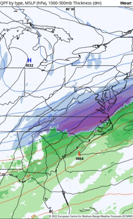
Amazingly similar look to todays 12z euro