

dallen7908
-
Posts
862 -
Joined
-
Last visited
Content Type
Profiles
Blogs
Forums
American Weather
Media Demo
Store
Gallery
Posts posted by dallen7908
-
-
46 minutes ago, C.A.P.E. said:
The bottom line lol.
With climo "normal" temps on the rise over the next couple weeks and no mechanism to deliver anomalous cold, there will still be plenty of days in the 50s.
I stand corrected.
-
EPS 15-day snowfall mean is at or near its seasonal low 0.5" for College Park.
The GEFS shows an improved EPO beginning around the 25th. EPS shows a positive EPO throughout. - no source of cold air
The NAO becomes less positive on both the GEFS and EPS.
The AO stays very positive on the EPS and positive on the GEFS - cold air bottled up to our north
As noted above, the PNA becomes neutral starting around the 23rd. - fewer days in the mid 50s
-
2 minutes ago, losetoa6 said:
Actually same day.. just afternoon . Gfs erodes it quickly . Sunday I'm referring to
Got it - could be close for some of our region
-
Unfortunately, the precipitation arrives during the afternoon of the following day so the CAD better be stout
-
49 minutes ago, PCT_ATC said:
yes they did 16.9" funny how I dont remember it!
... at least I have an excuse was in Tucson. I also missed the March storm from a couple of years ago - spring training. I'm having a hard time recalling the last time I saw it snow for more than a few seconds during daylight hours here.
18 UT GFS gives a trace of snow to the northern tier of MD Wednesday evening
-
The beat continues:
GEFS snowfall mean for College Park is less than 0.1" with no member having more than 1" during the next 10 days. During the same time period only 1 EPS member has more than 1". During days 10-15 the EPS mean is almost an inch driven by one member that shows a big storm around the 21st.
You want indices:
NAO and cousin AO + throughout both GEFS and EPS. EPS very +.
EPO + throughout but GEFS EPS does approach zero near the end of the run
PNA - until at least the 23rd
With the exception of next Friday and Saturday and perhaps the following Thursday (EPS only), highs are 10-15 degrees above normal.
Barring a fluke, it looks like we'll need a very late February or early March save (brought to you by Captain Obvious)
-
5 hours ago, psuhoffman said:
Made it into JH last night around 12:30. Drive from Idaho falls was longer because Teton pass was closed for avalanche control. Done a few runs through Saratoga bowl. Chest deep. They’ve had about 40” so far the last 3 days and it’s absolutely dumping right now. 2”/hr easy. It’s supposed to end late tonight then be sunny the next few days.


So happy for you. I saw snow this morning too while walking the dog--- in the beds of over a dozen rail cars carrying coal from West Virginia
-
 2
2
-
-
2 minutes ago, Ralph Wiggum said:
Usually take 7-10 days minimum to rebuild cold in that domain....another 5-7 days to transport it south. So maybe early March?
To all of you who couldn't find anything to like in the EPS

-
 1
1
-
-
4 minutes ago, C.A.P.E. said:
+PNA tho lol.
EPS looks worse. Absolutely no signs of improvement in the LR. Shutout look.
Yes +PNA by day 14!, also NAO decrease to near zero by day 16 as does EPO!
-
This week's 3-4 week forecast brings us almost to the end of the snowfall season. Warmer- and wetter-than normal is the forecast but we can live with 50-55% chance of above normal temperatures. I think last week's 2-category forecast gave us nearly a 70% chance of above normal temperatures.
https://www.cpc.ncep.noaa.gov/products/predictions/WK34/
The ECMWF and JMA models are in agreement for the Week 3/4 forecast, while the CFS is almost exactly out of phase with the others over North America. The ECMWF and JMA solutions feature anomalous ridging over the North Pacific and southeastern U.S., with the strongest anomalous troughing contained to eastern Canada. Both of these solutions suggest a +NAO pattern and the JMA is a bit stronger than the ECMWF. The CFS's solution has a similar height pattern over the North Pacific, but its positive anomalies extend further east and cover much of the western U.S. It also forecasts an anomalous trough over the eastern U.S. The SubX multimodel ensemble is very similar to the ECMWF and JMA solutions.
-
1 hour ago, WinterWxLuvr said:
That’s the best that has looked all year
yes it's great to see a few hits to our south. EPS mean is still only 2+"; however, at least for College Park
-
The 8-14 day outlook still calls for above normal temperatures and precipitation for MD/WV/DE. However, the forecast southeast ridge appears to be less extensive than yesterday as PA and NJ are now forecast to have normal temperature. The whole east coast south of VT/NH/ME was forecast to be above average for this period - yesterday.
Hopefully, we can salvage the last week of February and early March.
-
7 minutes ago, snowmagnet said:
Did the overnight EPS hold our glimmer of hope around Feb 20th?
5 to the 51 members give DC an appreciable snow event (>2-3") between the 18th and 21st.
-
I chased to Canaan Valley early Sunday. 28 degrees when I arrived with a few inches of snow on the ground mostly from an overnight storm (it started on Saturday as rain there too). Spent the day snow shoeing and XC skiing; however, by mid afternoon there were muddy spots on the White Grass trails
I think I heard about 5 seconds worth of pingers on the north side of the Beltway Sunday morning a bit after 6
-
Why do use the 90% contour line as the demarcation zone? Are you adjusting for the inherent cold bias in the GEFS?
-
Yes this belongs in the digital snow thread but wouldn't it be great to converge to the extreme solution for once
-
4 minutes ago, Ji said:
I wonder if we lost a bit from this weekend storm disaster
Yes that explains a portion of the decrease, especially in far northern MD.
-
1 hour ago, Ji said:
The eps snowfall mean got worse overnight. 2 inches for jyo.
I've been quietly tracking the percent of EPS members giving DC and "PSUland" 3" (or more!) for the period ending at 00 UT on February 8th. Here are the percentages for DC beginning with the 00 UT January 24th suite (360 hour forecast) and ending with the 00 UT January 29th run (240 hour forecast) (18,28,26,24,18,22, 24,18,16,10,14) and here are the percentages for far-northern central Maryland (34,46,30,38,28,28, 36,20,26,26,20). So yes the percentages are decreasing a bit as we move closer in time to the period of interest. Not sure if this is meaningful but is consistent with our winter so far.
-
1 hour ago, psuhoffman said:
Furthermore “the euro is rock steady” isn’t a thing anymore. I don’t know if it’s because it runs 4 times a day now vs once back in the day. Or if it’s higher resolution made it more accurate but also more prone to tangents. But it definitely jumps around with specifics run to run the last several years. But usually it’s goalposts are closer to the reality and it tends to catch on first. But it’s not 100% and you can’t just rip and read it’s long range output as a gospel forecast.
Yes I suspect the surface reflection of the 500 hPa pattern is more sensitive to small changes in the overall pattern at higher resolution; however, perception also plays a role. I'm not sure the Euro has ever been rock steady over the 6-10 day period we (are forced to ) focus on during periods non-conducive to snow
-
14 minutes ago, Mersky said:
it has passed the GFS and is currently third behind the euro and ukmet in accuracy. But at 10 days they all really should be viewed with skepticism.
Probably better to state that it is comparable to the GFS, here are day 7 anomaly correlations

-
22 hours ago, psuhoffman said:
Yes there is a lot more to do in N Conway. The Conway area gets blasted in those New England coastals being so close to the coast on the east face of the White Mountains. The town does get some shadow effect in the valley but still has frequent 12”+ storms and some 20+ which is kinda rare for valley locations in northern New England. Some of the more remote places in the mountains around Conway get obliterated in coastals.
I’m spending an extended weekend in North Conway following last weeks AMS meeting in Boston
xc skiing yesterday snow shoe race today they got 7-9 Thursday and are getting a similar amount tonight
-
Looking forward to the cold but let's keep expectations in check given the climatology of the GFS

-
7
-
-
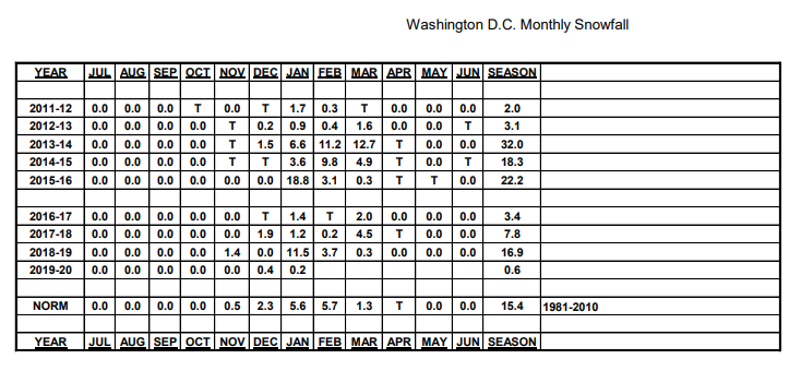
12/16 0.3"
1/7 0.4"
0.7" for season (College Park)
-
Looks like we may say goodbye to the 50s/60s beginning on the 6th with perhaps the highest 15-day snowfall mean from the EPS this season (3" with 2 HEC-like amount for immediate dC area)
PNA negative throughout but some hope for a negative EPS too
NAO positive for the next 10-14 days or so but could be negative late in the period
Hopefully, this improving pattern has legs; however the 3-4 week outlook from CPC issued yesterday calls for above normal temperatures and precipitation.
-
1
-


February Medium/Long Range Discussion
in Mid Atlantic
Posted
Six to 10 day outlook for Feb 19-23 calls for below normal temperatures and above normal precipitation in MD. Likely a cold and dry / cool and wet scenario given the unfavorable Pacific but who knows