a.salt
-
Posts
77 -
Joined
-
Last visited
Content Type
Profiles
Blogs
Forums
American Weather
Media Demo
Store
Gallery
Everything posted by a.salt
-

Jan 31st - 33rd Storm Obs and Disco like it's 1979
a.salt replied to Bob Chill's topic in Mid Atlantic
Dryslot in Millers! Sent from my SM-G960U using Tapatalk -
Jan 31st - 33rd Storm Obs and Disco like it's 1979
a.salt replied to Bob Chill's topic in Mid Atlantic
Light snow has begun in Millers! -
Sleet in Millers...6.5 inches before switchover
-
6 inches in Millers with heavy snow.
-
I hope!
-
I will, because I have snow!
-
lol just chill dude and enjoy the ride. You lose and others win. No big deal. Called life.
-
It's overtop me but I'm still inside the purple?
-
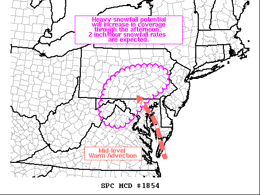
Mesoscale Discussion 1854 NWS Storm Prediction Center Norman OK 1257 PM CST Wed Dec 16 2020 Areas affected...Northeast West Virginia...northern Virginia...western Maryland...and central to eastern Pennsylvania Concerning...Heavy snow Valid 161857Z - 170000Z SUMMARY...Heavy snowfall rates around 2 inches per hour are expected to increase in coverage through the mid to late afternoon hours across portions of the Mid-Atlantic. Heavy snowfall will likely continue into the overnight hours for portions of eastern/northeastern Pennsylvania. DISCUSSION...Precipitation continues to gradually increase in coverage across much of the Mid-Atlantic region within a broad swath of strong warm air advection between 850-700 mb (per recent RAP soundings and mesoanalysis). Mixed precipitation types continue to be reported within the precipitation transition zone along the Roanoke to Fredericksburg, VA line. While a wintry mix, including pockets of freezing rain, will continue in the near term, this zone should become more limited spatially through the mid/late afternoon hours. Further north, moderate, to at times heavy, snowfall rates have been observed (as evidenced by visibility reductions to one-quarter mile and observed snow rates around 2 inches per hour for some locations in northeast WV). Heading through the afternoon, the low that is currently advancing northward along the Carolina coast will continue to deepen. As this occurs, mid-level winds will strengthen and begin to tighten the 850-700 mb baroclinic zone and augment warm advection across the region. As isentropic and frontogenetical lift increase, snowfall rates will see a corresponding uptick in intensity. Lift within the dentritic growth zone and weak instability closer to the coast will help further augment snowfall rates. Widespread snowfall rates above 1 inch per hour over the region are likely, and the potential for widespread snowfall rates exceeding two inches per hour will increase through 00 UTC as the potential for organized frontogenetical/deformation-driven snow bands increases.
-
1.5 inches in Millers with heavy snow.
-
Roads covered here in Millers. Close to an inch so far.
-
31 degrees and light snow in Millers. Close to a dusting already.
-
30/18 in Millers
-
31.0 degrees here in Millers with snow still on the ground from yesterday. Should keep things cold overnight.
-
Snow is ending here...total of 1 and a half inches. Enough for kids to sled and have fun!
-
Maps?
-
Mostly snow now in Millers...temp is still 39.0 degrees. Big, heavy flakes coming down.
-
Snow mixing with rain in Millers...temp has actually risen to 39.0 degrees
-
38.8 degrees here in Millers, MD with sleet mixing in.