LeesburgWx
-
Posts
1,997 -
Joined
-
Last visited
Content Type
Profiles
Blogs
Forums
American Weather
Media Demo
Store
Gallery
Everything posted by LeesburgWx
-
If it is going to rain, may as well bomb this bad boy as low as we can and enjoy the mini-cane
-
Severe season already?
-
Jan 2016
-
A good cluster of those Lows take a gorgeous track off Norfolk/DelMarVa
-
Honestly, I love the thrill of the hunt for the big storms even though they average like 5-7 years apart. But that’s a classic look on the Euro and it buried central VA verbatim. I just want a crawling storm and let the chips fall as they may.
-
Hide that map from Ji
-
December 22-23, 2022: Warm Rain to Arctic Chill
LeesburgWx replied to WxUSAF's topic in Mid Atlantic
So far, today has not disappointed. Now down to 15 degrees and still falling. Started this morning at 42 degrees. -
December 22-23, 2022: Warm Rain to Arctic Chill
LeesburgWx replied to WxUSAF's topic in Mid Atlantic
Gusting I’m the 30s now. Cold AF -
December 22-23, 2022: Warm Rain to Arctic Chill
LeesburgWx replied to WxUSAF's topic in Mid Atlantic
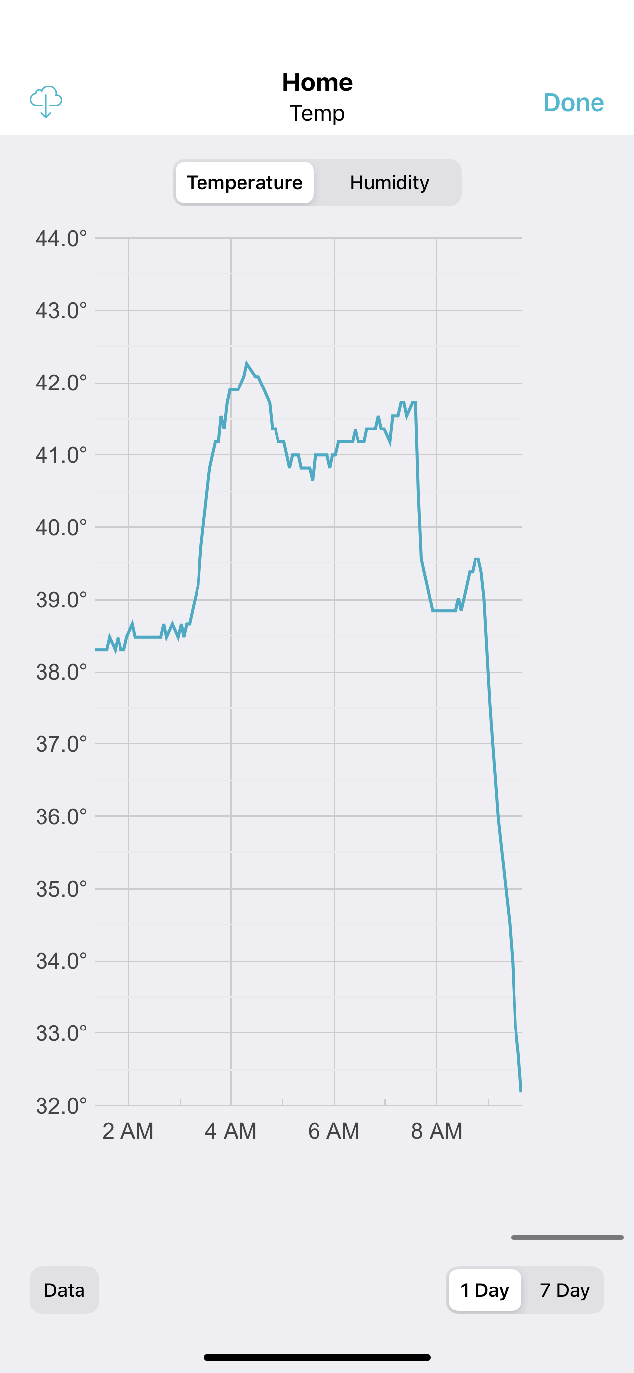
Look at the drop here in the last hour. 39.5 to 32 degrees in an hour
-
December 22-23, 2022: Warm Rain to Arctic Chill
LeesburgWx replied to WxUSAF's topic in Mid Atlantic
35 now. Starting to drop like a rock -
December 22-23, 2022: Warm Rain to Arctic Chill
LeesburgWx replied to WxUSAF's topic in Mid Atlantic
Lights flickering. Ugh -
December 22-23, 2022: Warm Rain to Arctic Chill
LeesburgWx replied to WxUSAF's topic in Mid Atlantic
Just dropped from 39 to 36.5 degrees now in 10 min -
December 22-23, 2022: Warm Rain to Arctic Chill
LeesburgWx replied to WxUSAF's topic in Mid Atlantic
Winds picking up now here in Leesburg. Just gusted to 24mph. Temp still steady at 39 for the molent -
December 22-23, 2022: Warm Rain to Arctic Chill
LeesburgWx replied to WxUSAF's topic in Mid Atlantic
Was 47 at 530am. Now 39 here and pouring rain. I want my flash freeze baby -
Throw the Op run out. I’m holding on to the Ensembles.
-
We suck
-
Digging hard!
-
I think we’re about to go digging boyz
-
Guys, we already know GFS is New King, hands down, if it pulls off this win. It starts with 18z today
-
This is actually very helpful to see the differences and is somewhat encouraging among all the negativity elsewhere.
-
Damn, this is great stuff. Who will waiver first?
-
I thought we were bad here, but wow, the NE thread is in total meltdown
-
After seeing the Euro De-throned by the GFS so many times recently, I am not jumping ship. The GFs ensembles pretty much matched the GFS Op. I’m putting my chips there.
-
And it’s not just bullseye snow, it 973 over OC, Maryland
-
Ok, we finally got the bullseye run. Can it hold? After all the let downs over the past year or two with hanging on to the euro as the King just to see the GFS say, hold my beer, I am certainly more comforted with having the GFS showing this solution vs euro