

mattny88
-
Posts
92 -
Joined
-
Last visited
Content Type
Profiles
Blogs
Forums
American Weather
Media Demo
Store
Gallery
Everything posted by mattny88
-
Upstate/Eastern New York
mattny88 replied to BuffaloWeather's topic in Upstate New York/Pennsylvania
-
Upstate/Eastern New York
mattny88 replied to BuffaloWeather's topic in Upstate New York/Pennsylvania
Dave I live up here in oswego..you think I should be worried about the lack of moisture being where weare located is in the nw edge of this storm..I'm worried about the precipitation cutoff..your thoughts? -
Upstate/Eastern New York
mattny88 replied to BuffaloWeather's topic in Upstate New York/Pennsylvania
yeah wolfie i see that northern band your speaking of...its pretty obvious and apparent that the original first band just south of fulton is not going to be heading north and if anything will be sliding south a little more..it loos like altmar and oswego both have to rely on the transient band that we are dealiing with now..thoughts? -
Upstate/Eastern New York
mattny88 replied to BuffaloWeather's topic in Upstate New York/Pennsylvania
yea im in the city of oswego wolfie and nothing man..the returns on radar look like the 2"+ per hour variety but it just doesnt want to seem to wiggle north and hit us or you up in altmar..what do you think? -
Upstate/Eastern New York
mattny88 replied to BuffaloWeather's topic in Upstate New York/Pennsylvania
awesome and how about you the other "cny-lesfreak" where are you located so i can put a location to the snow pics your sending -
Upstate/Eastern New York
mattny88 replied to BuffaloWeather's topic in Upstate New York/Pennsylvania
yea minetto and points north look to get the short end of the stick this go around..winds are veering more northwest and becoming better aligned with computer models..i was hoping city of oswego would get hit now and then as the bands usually do there meandering north and south but even then i just think were a tad too far north this go around..whats your thoughts on city of oswego.. cny-lesfreak? keep the pictures coming man and updates...hows the dendrite growth of the snow..are they the typical fine granular flakes that the lake produces? -
Upstate/Eastern New York
mattny88 replied to BuffaloWeather's topic in Upstate New York/Pennsylvania
wow not bad at all..where you located again? -
Upstate/Eastern New York
mattny88 replied to BuffaloWeather's topic in Upstate New York/Pennsylvania
yea in oswego its just flurries..the alledged band that showed up on radar was quite deceiving or maybe some virga and it moistening up the upper layers cause the rate of intensity was just not there with that little moisture that came through..so you think so huh cny lesfreak more of a wnwesterly component..i hope so even tho all the models tend to suggest otherwise..speaking of models what site do you guys use??? will nws update their map you think or no? -
Upstate/Eastern New York
mattny88 replied to BuffaloWeather's topic in Upstate New York/Pennsylvania
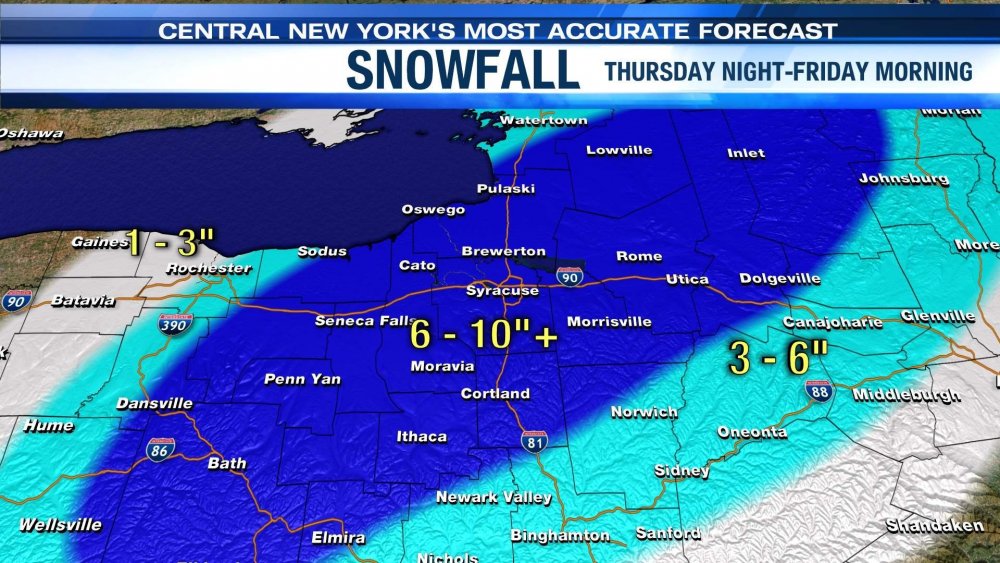
thanks wolfie and matty you guys are awesome..exactly what i was looking for...hey so the 2 snow maps i just sent above...i noticed there are differences between the 2 major news outlets wsyr news channel 9 and cny central weather team...for example take on the wsyr map of where would be the city of oswego and look at the few mile variance of where the city is located and then where they have the 8-12, 4-8, and 2-4 inch range..for city of oswego itself, personally if you were to put a number on it...based on your guys experiences how much snow do you think the city of oswego will receive..based on those maps the variance between the bullseye and 2-4 is only but a few miles...i can tell you with this storm my gut is telling me fair haven, fulton, hannibal, cato over to pheonix..that corridor where the population seems to be more remote will be the most hardest hit areas..i want to know your guys thoughts...also lets talk about the current radar returns..that band that is forming is not the same band that will be affecting us in the wee morning of the hours is it..i noticed molly mattott on cny central talk about the band meagering a little as opposed to being stationary like they were previously forcasting -
Upstate/Eastern New York
mattny88 replied to BuffaloWeather's topic in Upstate New York/Pennsylvania
cny snow map.html -
Upstate/Eastern New York
mattny88 replied to BuffaloWeather's topic in Upstate New York/Pennsylvania
snow map.html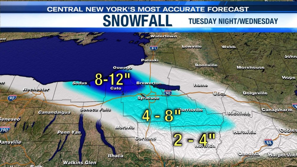
-
Upstate/Eastern New York
mattny88 replied to BuffaloWeather's topic in Upstate New York/Pennsylvania
yea oswego is really unique..because you think being close to the lake we get alot of lake effect which im not denying because we do...but in my 6 years having lived here now i tend to notice that during a high wind lake effect event the the lake effect will actually deposit the snow quite a few miles inland towards fulton and your location down in clay... and kind of skip the immediate lakeshore locales..also the close proximity to the lake more often then not hinders early season snowfall and more of the mixed variety rather then snow actually sticking even compared to other lower elevation towns like fulton...just interesting the locality of the lake and its influences so locally -
Upstate/Eastern New York
mattny88 replied to BuffaloWeather's topic in Upstate New York/Pennsylvania
thanks to all..yes sir we have all sectors of the region getting covered...nothing beats checking the radar and looking at your window in real time to provide updates and so forth...hey cny-lesfreak i have a ?..speaking of the wind flor being 295 currently..do you have a localized map that provides this cny area of the wind vector based on the flow..i have followed this forum for a while without ever registering and i want to say last year i recall seeing such a map that had a great visual of what the lake effect wind flow looked like and tried to go back to look it up but couldnt find the map..thanks bud -
Upstate/Eastern New York
mattny88 replied to BuffaloWeather's topic in Upstate New York/Pennsylvania
Hey guys im new to this amerian weather forum... im from oswego ny and i am a huge winter weather enthusiast particularly for pure lake effect snow events..so lets get this forum going full tilt tonight shall we.. anybody want to take and how much you think being up here lakeside right on the water in oswego will receive.. i currently am looking at the radar loop and the lake band is starting to come onshore and intensity about 15 miles to my southeast near the northeast wayne/cayuga county border on a northwest wind...ive tend to noticed the city of oswego itself gets slammed good with more of a west-northwest wind..so i need that band to wiggle north for a few hours to get a few inches out of it..whats everyones thoughts


