Jump to content

mattny88

Members
  • Posts

    92
  • Joined

  • Last visited

Everything posted by mattny88

  1. Wonder if news Channel 9 will increase there snow totals as well in there 5pm news broadcast based on the latest model runs? I tend to notice they always seem a tad conservative with there totals vs nbc3 and news channel 5...
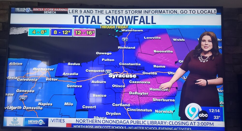
  2. WSYR NEWS CHANNEL 9 newest updated snowfall map for tonight... based off this map looks like they have adjusted the highest snow totals and bullseye for the lake effect band to set up over southern oswego county into the night
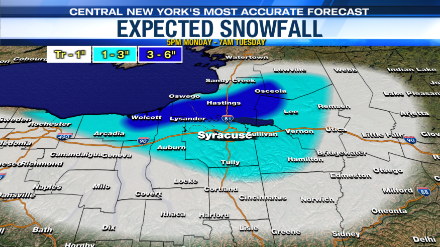
  3. WSYR local meteorologist are calling for 1-3 as the band oscillates and then it looks like they went with more of the southern model run of a band setting up shop over eastern cayuga/southwest onondaga. i am with you tughillmatt, my name is matt as well and i just relocated last year from oswego down here to liverpool right off soule rd about a minute from rte 31...being new to the route 31 corridor, what kind of wind is the best setup for us that can produce a stationary band that doesnt jump right over us? Is there any historical archive maps of northern onondaga county that reflect past big pure lake effect events other then nws maps..i would assume a west to north west wind with more towards a northwest wind would be almost ideal..i was accustomed to oswego getting the winds on a west to slightly west north west wind. but i tended to find that oswego had to have pretty light calm winds for a big time stationary band to set up over the city of oswego... i drive daily from liverpool to oswego and traveling up 481 the fulton/volney area always seems to be the sweet spot..let me know your thoughts with this storm regarding snow amounts and in general for northern onondaga. Also if anyone can help me out and repost what i had seen a picture of from a good while back. it was a picture of the direction of the wind flow it had different arrows coming off the lake and for each arrow it showed the degree of wind flow for each angle. would like a picture to relate to when the national weather service discussion talk about the wind direction degree relating it to my area.. Thanks everyone
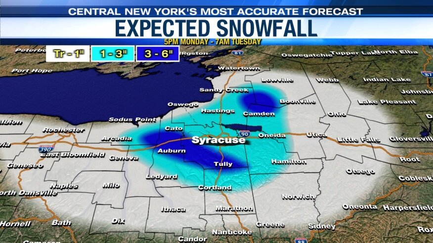
  4. Hey tughill just measured 4.5" not to far from you as i live off soule rd in liverpool..what site do you watch the webcam locations at! We had a lull for past 30 minutes but now its definitly starting to come down again
  5. Per the NWS they just upgraded to a winter storm warning for oswego county...6-12 inches..Wolfie i live within the city of oswego..do you think our location is a tad to far north to get into the real deformation banding zone that they are calling for down south closer to the syracuse area..i just didnt know if that westward jog on the models brought the heavier precip. further northwest to include the lake shore communities..how much you projecting snow amounts for us..
  6. hey guys,so i live in the city of oswego and out of the nws buffalo AFD the sentence what caught my eye was "with a single plume of heavy snow likely across Oswego county".. with that said how much you think we are talking about..intensity wise of the band and the duration and snowfall amounts?...im assuming there will be a wnw or westerly component to the wind?? the city of oswego usually does will when the winds are lighter being we are right on the lake..some lake effect strorms tend to blow right over us..also was seeing if you guys could post an image or two of the models lake effect run for tuesday evening after the synoptic storm passes..thanks guys
  7. hey guys just wanted to see what the weather is looking for going into next week as the colder air pushes in..is first flakes and/or synoptic/any lake effect snow chances a reality.. i live up here in oswego ny and just am curious because its getting to be that time of year again. I am wanting to start up the chatter and model runs to see the possibilities thanks guys!!
  8. hey there syrmax..looking into relocating in phoenix...is the phoenix area more comparable to fulton or clay (route 31 corridor) when it comes to lake effect snowfall.. i know its sandwiched right in between the two as the transient town from which route 481 connects them i just didnt know what your experience has been like living in clay vs phoenix and in relation to fulton....didnt know if that wnw lake band that desposits over fulton usually extend down into phoenix most of the time during the 2-3 ft lake storms that fulton receives from time to time??
  9. what are you guys thinking about the city of oswego accumulations wise?
  10. city of oswego received about 6-7inches overnight when i woke up for work...what do you guys expect out of the city of oswego for tonights lake effect band? i think city of oswego could be the center point of the band or do you guys see more of a northwesterly wind component pushing the band south more into fulton and northern cayuga?
  11. I live it the city of oswego... looks like we are the bullseye..how much we looking at guys?
  12. How is the city of oswego looking wolfie with the windflow being around 280..im hoping for once tgus season a sustained wnw flow keeps us in a single plume band streaming off the lake in a rare early march lake effect effect amount to feet. Your thoughts in accumulation totals? Thanks
  13. Wolfie, tughill, and cnylesfreak how much snow would you guys peg the city of oswego getting tonight once the winds align wnw?? Just Looking at that hhr map accum. Map and it off looks like such a tight gradient...Im up here by the suny oswego college looking due north and you can visually see the plume of lake effect band pummeling so Jeff, and northern oswego...also how long does that lake effect band kn a wnw flow stay stationary tonight?? Or do youbguys seeing it oscillating some?? Thanks guys
  14. Need your guys hrlp and thoughts? How much snow amounts you guys thinking for the city of oswego later this evening and into tonight once the winds toward mpre wnwesterly???
  15. hey guys i live in the city of oswego...how am i looking snow accumulation wise with this impending lake effect event...reading the forum discussion it looks as tho the winds as shifted to a rarely sustainable w-nw flow which i think would be primed for oswego to really be the bullseye..wanting to see your guys expertise and thoughts on who looks to be in the sweet spot being that were only 36 hours away from this lake effect event..thanks guys!!!
  16. Everybody go to jeremy kappel 945 pm facebook live page he is the rochester meteorologist who got fired from whec 10 news..he has some really great analysis and updates on the storm..his videos are usually always at least 15 minutes and he answers questions us weather ethusiasts may have..Highly recommend tuning in at 945
  17. Wow you really thonk baseline 2ft w upwards of 3 ft a very distinct possobi ility for oswego tim? That wpuld be fantastic
  18. Wolfie tim or cnylesfreaj how much snow totals of you were to give an amoint for oswego cty...particularly city of oswego given the model runs and kuchara???? Much appreciated
  19. How much totals for the city of oswwgo you thinking guud w us getting alot of lake emhanced??
  20. How much you thinking tim wolfie and cnylesfreak for oswego county particularly the city of oswefo where i just got home and am settled in for the night staying up all n8ght to snowblow and look put the window and check the radar maybe eat some food and be om this forum..in full storm mode right now lets goooo im stoked
  21. 3.4 already in walworth...wow thanks for he update..my parents in ontario prolly have the same then...how is the dendrite flake size and current intensity? you guys are well on your way to 2 feet
  22. wolfie if the low pressure adjusted and tracked further north into southern ny state..where would that tend to bring the rain/snow/mix line up to...ya gotta figure that would do nothing but continue to favor north central/western ny correct??? thoughts
  23. it shows 27" for the city of Oswego...please let this verify...we are in storm team mode...i keep watching the radar updating every few minutes...im down here in the war room checking all the latest updates this is awesome...
×
×
  • Create New...