mattny88
-
Posts
92 -
Joined
-
Last visited
Content Type
Profiles
Blogs
Forums
American Weather
Media Demo
Store
Gallery
Everything posted by mattny88
-
Upstate/Eastern New York
mattny88 replied to BuffaloWeather's topic in Upstate New York/Pennsylvania
yes i agree with charlee in pulling one last kuchara map that coincides w the output from the latest Euro..tim can you make this happen for us? and bring up a kuchara map of euro...much appreciated man -
Upstate/Eastern New York
mattny88 replied to BuffaloWeather's topic in Upstate New York/Pennsylvania
check out this hidden gem i found guys... Location Snow Amount Potential Chance of Seeing More Snow Than Low End Snowfall Expected Snowfall High End Snowfall >=0.1" >=1" >=2" >=4" >=6" >=8" >=12" >=18" Albion, NY 12 17 21 100% 100% 100% 100% 99% 97% 84% 33% Batavia, NY 10 13 18 100% 100% 100% 100% 100% 97% 71% 12% Buffalo, NY 9 10 16 100% 100% 100% 100% 100% 95% 51% 8% Canandaigua, NY 12 17 21 100% 100% 100% 100% 100% 99% 88% 38% Dansville, NY 10 16 17 100% 100% 100% 100% 98% 95% 72% 6% Dunkirk, NY 9 11 17 100% 100% 100% 100% 99% 94% 55% 9% Fair Haven, NY 12 17 24 100% 100% 100% 100% 99% 97% 86% 47% Fulton, NY 12 17 23 100% 100% 100% 99% 99% 96% 85% 45% Jamestown, NY 9 13 19 100% 100% 100% 100% 98% 94% 67% 17% Lockport, NY 9 13 17 100% 100% 100% 100% 99% 95% 64% 10% Lowville, NY 8 13 18 100% 100% 99% 97% 93% 85% 57% 14% Newark, NY 13 18 24 100% 100% 100% 100% 100% 99% 92% 52% Niagara Falls, NY 8 10 14 100% 100% 100% 100% 98% 87% 37% 2% Olean, NY 10 15 18 100% 100% 100% 99% 97% 92% 68% 11% Oswego, NY 11 15 23 100% 100% 100% 100% 99% 97% 85% 43% Rochester, NY 13 20 23 100% 100% 100% 100% 99% 97% 88% 50% Springville, NY 10 12 18 100% 100% 100% 100% 100% 98% 69% 17% Warsaw, NY 12 14 20 100% 100% 100% 100% 100% 99% 87% 29% Watertown, NY 7 10 16 100% 100% 100% 99% 95% 84% 46% 8% Wellsville, NY 10 16 19 100% 100% 100% 99% 97% 93% 72% 14% -
Upstate/Eastern New York
mattny88 replied to BuffaloWeather's topic in Upstate New York/Pennsylvania
tim you should do well..walworth always tends to exceed expectations due to being a touch more inland and it even being a tad hillier there to deposit that lake enhancement...enjoy it man -
Upstate/Eastern New York
mattny88 replied to BuffaloWeather's topic in Upstate New York/Pennsylvania
per NWS AFD did anyone catch up paragraph " As mentioned...the center of the cyclone was found over the Lower Mississippi Valley at 15z. The system will track to the northeast across Kentucky and West Virginia to about the Mason Dixon Line... which is about 25 to 50 miles further north than most guidance packages were suggesting. This subtle shift is being verified by pressure falls over Ohio and West Virginia. If this trend continues...it should lead to slightly stronger winds and possibly more snow. The reason for the shift is an earlier phasing of the two branches of the jet. This is starting to become apparent in WV imagery." that 25-50 mile difference..do you think thats enough to displace the old snow maps of just se of syracuse getting the jackpot to now the entire i90 corridor including roc, syracuse -
Upstate/Eastern New York
mattny88 replied to BuffaloWeather's topic in Upstate New York/Pennsylvania
thats a great radar look vortmax of the n-ne wind component giving way to lake enchanced into the west burbs of rochester -
Upstate/Eastern New York
mattny88 replied to BuffaloWeather's topic in Upstate New York/Pennsylvania
why isnt NWS upping there snow totals based on the Kuchara w it factoring in the snow ratios as opposed to per qpf?? -
Upstate/Eastern New York
mattny88 replied to BuffaloWeather's topic in Upstate New York/Pennsylvania
puts sodus at 50% of 18+ per NWS.... -
Upstate/Eastern New York
mattny88 replied to BuffaloWeather's topic in Upstate New York/Pennsylvania
great thanks vortmax..my parents live in ontario right off lincoln road...turn left at light at tractor supply off 104..about 2 miles south of 104 on lincoln..so theyve been giving me updates..yea man wayne county in specific looks to be the absolute jackpot with this storm with the lake enhancement....reminds me of valentines day storm of 2007 even though i wasnt living here at that time but from the locals -
Upstate/Eastern New York
mattny88 replied to BuffaloWeather's topic in Upstate New York/Pennsylvania
lets get some more model snow maps going on in this forum shall we....hows the snow spotters and reporters looking out in Rochester guys?? -
Upstate/Eastern New York
mattny88 replied to BuffaloWeather's topic in Upstate New York/Pennsylvania
lets talk about the northwest shift and trend in the model within these last few hours...how much does that affect bumping snow totals up..i want your guys thoughts on this conversation..thanks alot guys -
Upstate/Eastern New York
mattny88 replied to BuffaloWeather's topic in Upstate New York/Pennsylvania
wolfie the colder soundings coming from the lakeshore communities of oswego county, does that boast more snow in regards to the snow ratios being higher..i just wory about the grainy small dendrite type flake that doesnt add up...also what do you guys think? the nws will up there totals...weather spotters out in Rochester are already alledgely reporting 3 inches and it wasnt suppose to start this early...its snowing here in oswego but nothing of great intensity...with small flakes..the wind here is more noticeable then inland locations -
Upstate/Eastern New York
mattny88 replied to BuffaloWeather's topic in Upstate New York/Pennsylvania
hey tughill matt....my name is matt as well...how accurate is that kuchara map..i live in city of oswego..if that map verifies it shows me upwards of nearly 30"??? wanted to know your thoughts -
Upstate/Eastern New York
mattny88 replied to BuffaloWeather's topic in Upstate New York/Pennsylvania
So what ru saying wolfie that the local tv mets went w the NAM when projecting their snow maps vs the RGEM?? -
Upstate/Eastern New York
mattny88 replied to BuffaloWeather's topic in Upstate New York/Pennsylvania
last one...that is 4 different tv news station maps i just showed you all showing very different totals based on where ya live
-
Upstate/Eastern New York
mattny88 replied to BuffaloWeather's topic in Upstate New York/Pennsylvania
or perhaps cny central map...haha there all over the place and how there own reasons and thinkings...which one is the most accurate and do these align w what the latest models are showing us?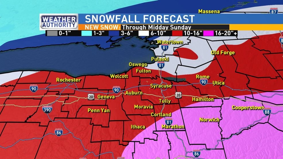
-
Upstate/Eastern New York
mattny88 replied to BuffaloWeather's topic in Upstate New York/Pennsylvania
would this be an example of what your referring to ...gotta love the consistency between the 2 stations haha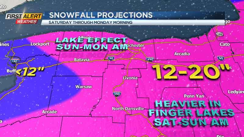
-
Upstate/Eastern New York
mattny88 replied to BuffaloWeather's topic in Upstate New York/Pennsylvania
i wish they did..this was used as of their noon air broadcasting -
Upstate/Eastern New York
mattny88 replied to BuffaloWeather's topic in Upstate New York/Pennsylvania
hate to be the bear of bad news...just saw trusted reliable source wsyr new snowfall map...not looking promising for the western edge..even me in the city of oswego there now calling for 5-10inch range..down from the 10-18 inch snow map they put out early this morning..what gives? what did they see in the latest models to suggest pushing the slug of greater accumulations and shifting the entire map like 30 miles east???? cnylesfreak? or wolfie or anybody know the reason and on board with their thinking? let me know guys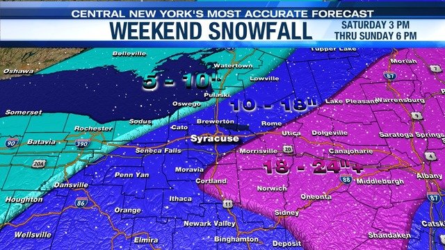
-
Upstate/Eastern New York
mattny88 replied to BuffaloWeather's topic in Upstate New York/Pennsylvania
i think for giggles and as a friendly contest...we should all create our own snow maps and see who ends up closest to the tallies that will come from this storm -
Upstate/Eastern New York
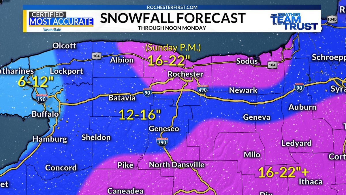
mattny88 replied to BuffaloWeather's topic in Upstate New York/Pennsylvania
what snow map do you guys think has it better depicted...wsyr news channel 9, cny central, whec 10. wham 13 or rochesterfirst between these 5 local TV met stations?? -
Upstate/Eastern New York
mattny88 replied to BuffaloWeather's topic in Upstate New York/Pennsylvania
can you get the map what that would be with the ratios kicking into effect..im curios to see that map haha -
Upstate/Eastern New York
mattny88 replied to BuffaloWeather's topic in Upstate New York/Pennsylvania
Great answer to my question lescnyfreak...got another ? for ya my man...ok so if you looked back on this forum page 12 it shows a picture of the ukmet precip totals... That sliver of yellow of more then 1+ precip extends from a big portion of eastern NY (albany area) westward to include our area ...my question is how did the northward trend of the low pressure adjusting the snow amounts westward...i am for some reason thinking that they would be adjusted northward but like north as is north of Albany not extending westward like they are..is this verifies it really does look like we would get a direct hit and be in the bullseye if i stand corrected..let me know thoughts boys -
Upstate/Eastern New York
mattny88 replied to BuffaloWeather's topic in Upstate New York/Pennsylvania
i am loving this guys....?? when do you think NWS Buffalo will upgrade their amounts seeing that the models have changed or do you think they will still air on the side of being conservative -
Upstate/Eastern New York
mattny88 replied to BuffaloWeather's topic in Upstate New York/Pennsylvania
W the snow ratips included in that last map w the kuchera sitting at 20:1 ratios thst could very well happen and be max totals and best case scenario..northwest cayuga/sw/central oswego seem to he the bullseye... -
Upstate/Eastern New York
mattny88 replied to BuffaloWeather's topic in Upstate New York/Pennsylvania
Awesome cnylesfreak Whats the likelihood of this euro verifying behind were 24 hours out now from the first flakes flying from this storm? You also said thats the big ? What were you referring to?