Ecanem
-
Posts
162 -
Joined
-
Last visited
Content Type
Profiles
Blogs
Forums
American Weather
Media Demo
Store
Gallery
Everything posted by Ecanem
-
Western PA/Pittsburgh Winter 2021/22 Discussion
Ecanem replied to meatwad's topic in Upstate New York/Pennsylvania
Weather app reports wintery mix. It’s definitely not a mix in the mountains -
Western PA/Pittsburgh Winter 2021/22 Discussion
Ecanem replied to meatwad's topic in Upstate New York/Pennsylvania
Dumping. no rain. https://imgur.com/a/spOJIGs -
Western PA/Pittsburgh Winter 2021/22 Discussion
Ecanem replied to meatwad's topic in Upstate New York/Pennsylvania
Will let you know when this hits me. currently snow tubing. -
Western PA/Pittsburgh Winter 2021/22 Discussion
Ecanem replied to meatwad's topic in Upstate New York/Pennsylvania
Flakes are falling at springs. -
Western PA/Pittsburgh Winter 2021/22 Discussion
Ecanem replied to meatwad's topic in Upstate New York/Pennsylvania
Not in gfs. That’s snow. -
Western PA/Pittsburgh Winter 2021/22 Discussion
Ecanem replied to meatwad's topic in Upstate New York/Pennsylvania
Good point. I don’t see the 540 line getting above Pittsburgh in the entire gfs run. -
Western PA/Pittsburgh Winter 2021/22 Discussion
Ecanem replied to meatwad's topic in Upstate New York/Pennsylvania
All the short range models have this low just riding up the Appalachians now. The question remains of how far the deform bands set out and how much dry slot there is. -
Western PA/Pittsburgh Winter 2021/22 Discussion
Ecanem replied to meatwad's topic in Upstate New York/Pennsylvania
I was 11. Probably thought it was a minor storm compared to 93. -
Western PA/Pittsburgh Winter 2021/22 Discussion
Ecanem replied to meatwad's topic in Upstate New York/Pennsylvania
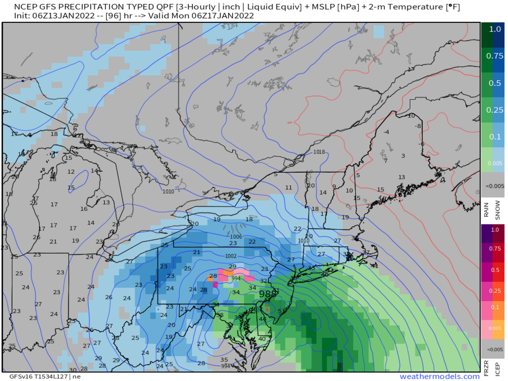
What’s the closest analogy to this storm? Honestly I’ve been following storms since the accuweather forums and I just can’t remember one that has this much QPF -
Western PA/Pittsburgh Winter 2021/22 Discussion
Ecanem replied to meatwad's topic in Upstate New York/Pennsylvania
All this talk makes me question. Hrrr vs NAM. And then I found this. and im still confused -
Western PA/Pittsburgh Winter 2021/22 Discussion
Ecanem replied to meatwad's topic in Upstate New York/Pennsylvania
Is anyone as nervously excited that I am? My friends and family know me as the ‘weather guy’ asking me what I think is going to happen. I’m optimistic for a good snow but the 2019? WSW bust is still fresh in memory. -
Western PA/Pittsburgh Winter 2021/22 Discussion
Ecanem replied to meatwad's topic in Upstate New York/Pennsylvania
So I’m really wondering how much snow we’re gonna get here at seven springs. There’s always a few more inches than the forecasts. I’m wondering we we could go to 1-2 feet -
Western PA/Pittsburgh Winter 2021/22 Discussion
Ecanem replied to meatwad's topic in Upstate New York/Pennsylvania
Well if we are in the dry slot this early. That means we should be good come storm time. -
Western PA/Pittsburgh Winter 2021/22 Discussion
Ecanem replied to meatwad's topic in Upstate New York/Pennsylvania
I’ve seen some still question a coastal track. That seems so dead to me at this point. -
Western PA/Pittsburgh Winter 2021/22 Discussion
Ecanem replied to meatwad's topic in Upstate New York/Pennsylvania
I know you say this. But storms always seem to shift east at the last minute. At least we are in that zone now. -
Western PA/Pittsburgh Winter 2021/22 Discussion
Ecanem replied to meatwad's topic in Upstate New York/Pennsylvania
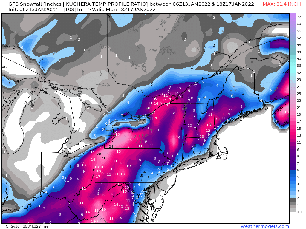
Gfs is very similar. -
Western PA/Pittsburgh Winter 2021/22 Discussion
Ecanem replied to meatwad's topic in Upstate New York/Pennsylvania
Gfs through 12z Sunday isn’t looking much different than 18z. The 500mb dips a little more into GOM. -
Western PA/Pittsburgh Winter 2021/22 Discussion
Ecanem replied to meatwad's topic in Upstate New York/Pennsylvania

-
Western PA/Pittsburgh Winter 2021/22 Discussion
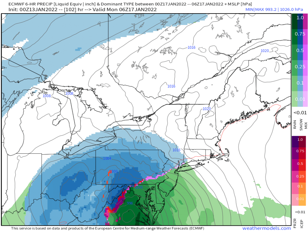
Ecanem replied to meatwad's topic in Upstate New York/Pennsylvania
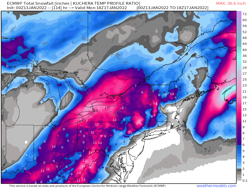
6Z GFS vs 00Z Euro, tracks arent that far off. 0Z Euro seems less amped. Both snow track and low location on Monday morning,.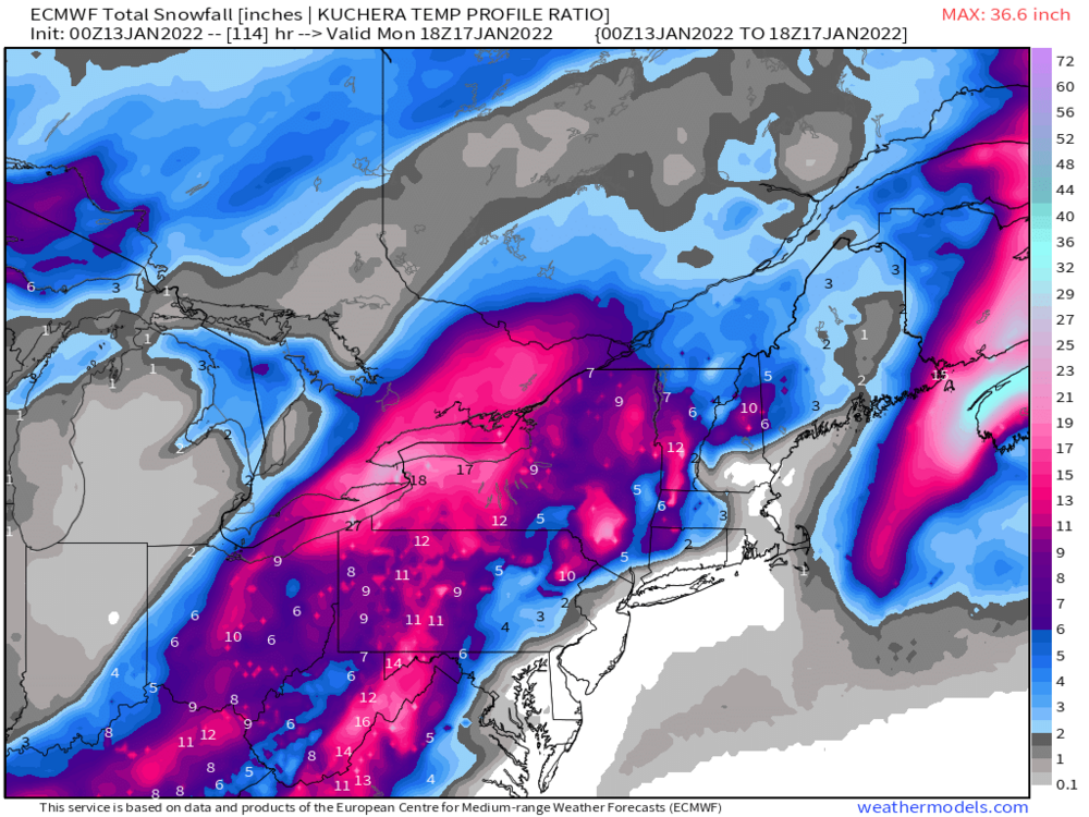

-
Western PA/Pittsburgh Winter 2021/22 Discussion
Ecanem replied to meatwad's topic in Upstate New York/Pennsylvania
Seven Springs. Aka in that euro 22” zone. -
Western PA/Pittsburgh Winter 2021/22 Discussion
Ecanem replied to meatwad's topic in Upstate New York/Pennsylvania
Soooo I am going skiing this weekend.... really would stink to get 'snowed in' on monday and tuesday. -
Western PA/Pittsburgh Winter 2021/22 Discussion
Ecanem replied to meatwad's topic in Upstate New York/Pennsylvania
GFS 12Z rolling in is looking closer to 00Z looks a little stronger on the 500mb too. Let's see where it goes. -
Western PA/Pittsburgh Spring Discussion 2021
Ecanem replied to Ahoff's topic in Upstate New York/Pennsylvania
Didn’t realize we had a new thread. Posting for alerts. -
Western Pa / Pittsburgh area Winter Discussion ❄️☃️
Ecanem replied to north pgh's topic in Upstate New York/Pennsylvania
Shocked that this thread is dead after the snow today. My grass is almost completely covered. -
Western Pa / Pittsburgh area Winter Discussion ❄️☃️
Ecanem replied to north pgh's topic in Upstate New York/Pennsylvania
As a skier. This winter was an A+++++ probably too 1-2 of the last decade.