Ecanem
-
Posts
162 -
Joined
-
Last visited
Content Type
Profiles
Blogs
Forums
American Weather
Media Demo
Store
Gallery
Everything posted by Ecanem
-
Back for another fun season. It looks like the models still don't have consensus on this thing. ICON has this much further east and faster. Euro is faster and West GFS is west but slower CMC looks like it still wants to transfer off the coast. Obviously the bullseye a week out is bad. With that said, we have seen these things shift massively with just days notice. The energy for this looks like its not coming until Tuesday/Wednesday which means we have a lot of shifts to come.
-
Western PA/Pittsburgh Winter 2021/22 Discussion
Ecanem replied to meatwad's topic in Upstate New York/Pennsylvania
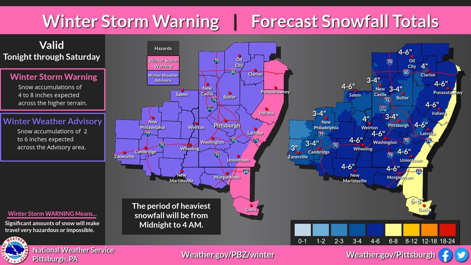
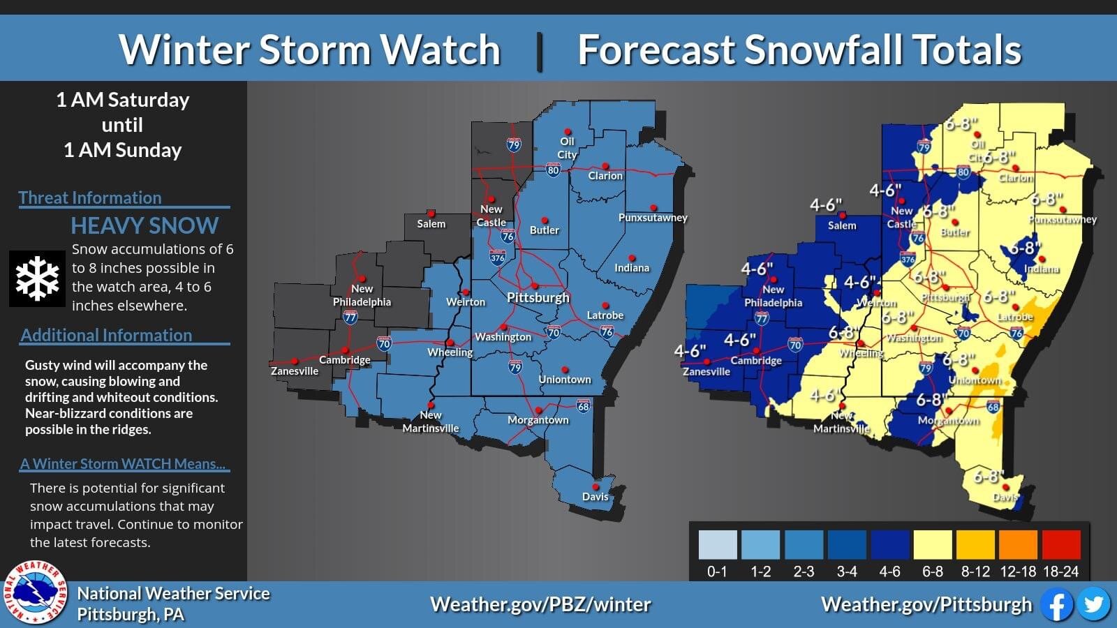
Nws lowered totals. Wwa now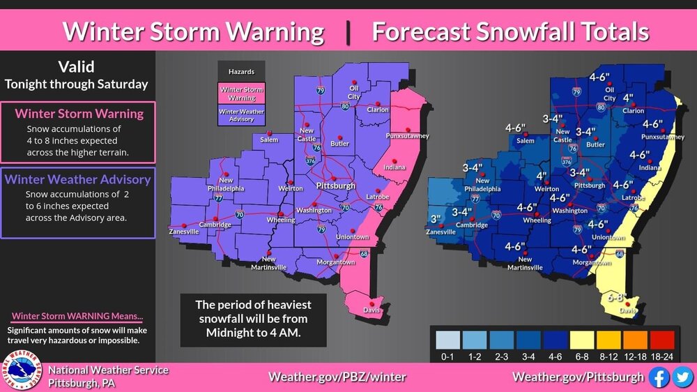
-
Western PA/Pittsburgh Winter 2021/22 Discussion
Ecanem replied to meatwad's topic in Upstate New York/Pennsylvania

-
Western PA/Pittsburgh Winter 2021/22 Discussion
Ecanem replied to meatwad's topic in Upstate New York/Pennsylvania
I’m up at seven springs and we got a Nice 3+ inches of snow last night. Nice and fluffy too. -
Western PA/Pittsburgh Winter 2021/22 Discussion
Ecanem replied to meatwad's topic in Upstate New York/Pennsylvania
Just woke up to what seems like a mess of wintry mix on the ground. 23.9 degrees and currently in a dry slot with what looks like a strong snow band on the way -
Western PA/Pittsburgh Winter 2021/22 Discussion
Ecanem replied to meatwad's topic in Upstate New York/Pennsylvania
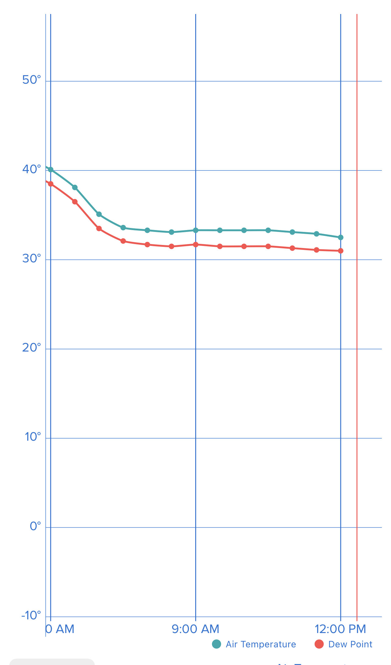
31.6 and a trace of ice on metals -
Western PA/Pittsburgh Winter 2021/22 Discussion
Ecanem replied to meatwad's topic in Upstate New York/Pennsylvania
Just crossed 1” of rain. Also still holding at 32 -
Western PA/Pittsburgh Winter 2021/22 Discussion
Ecanem replied to meatwad's topic in Upstate New York/Pennsylvania
I don’t understand these schools. Today cancelled. Tomorrow 2 hour delay. -
Western PA/Pittsburgh Winter 2021/22 Discussion
Ecanem replied to meatwad's topic in Upstate New York/Pennsylvania
My backyard near Bridgeville 79 exit has been hovering just above freezing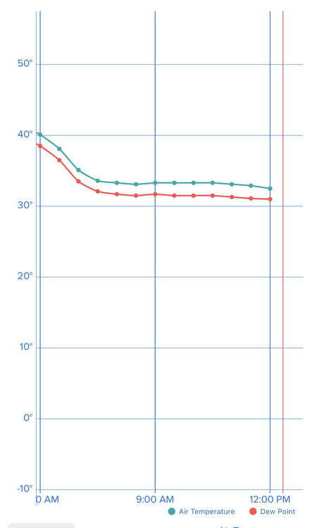
-
Western PA/Pittsburgh Winter 2021/22 Discussion
Ecanem replied to meatwad's topic in Upstate New York/Pennsylvania
We’re looking at like a 20 mile shift on the hrrr. It could be anything tomorrow. We are right on the border. -
Western PA/Pittsburgh Winter 2021/22 Discussion
Ecanem replied to meatwad's topic in Upstate New York/Pennsylvania
Honestly, I feel like with winter storms. If you are expecting snow 24+ hours out. You end up disappointed. -
Western PA/Pittsburgh Winter 2021/22 Discussion
Ecanem replied to meatwad's topic in Upstate New York/Pennsylvania
My kids school already prepped them for a 'fid' day tomorrow (no more snow days, just school from home now). Interesting is that most of the storm would come after the morning but there could be an issue getting home from school., -
Western PA/Pittsburgh Winter 2021/22 Discussion
Ecanem replied to meatwad's topic in Upstate New York/Pennsylvania
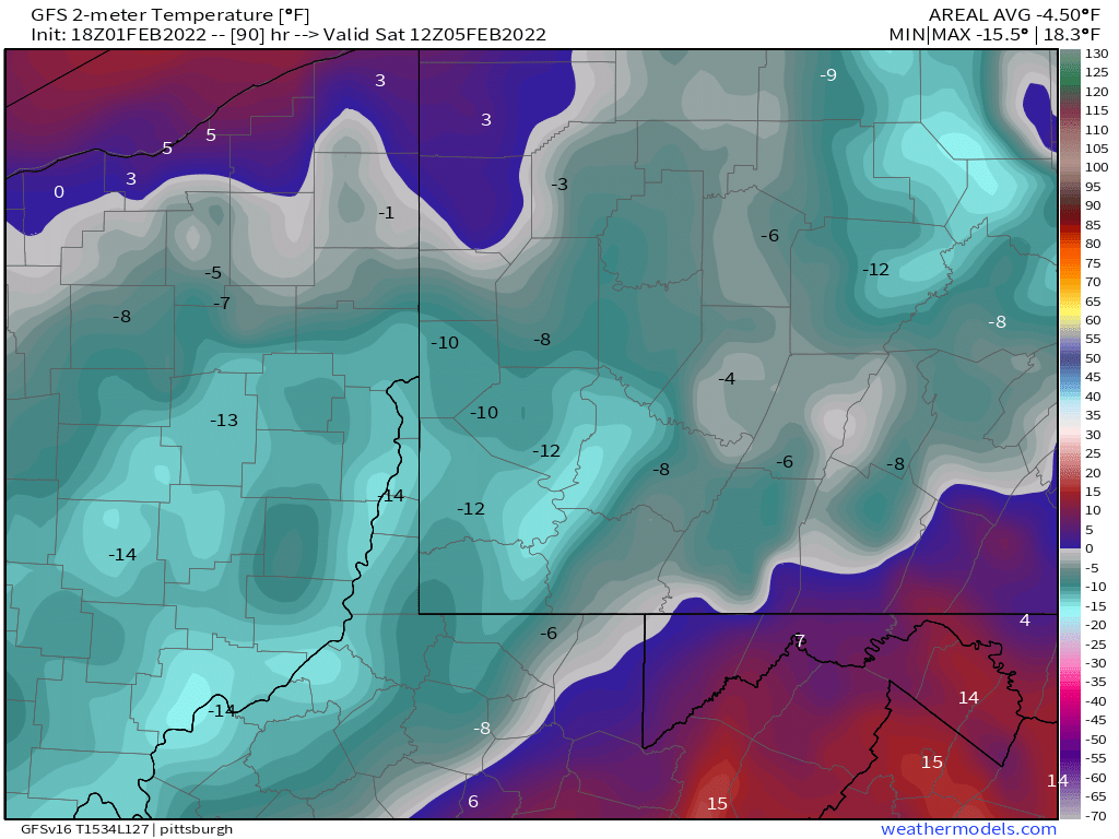
Can we talk about Saturday morning temperature again?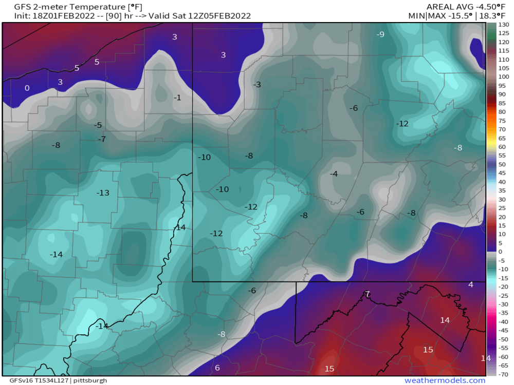
-
Western PA/Pittsburgh Winter 2021/22 Discussion
Ecanem replied to meatwad's topic in Upstate New York/Pennsylvania
Just got up. Current air temp at my house in Upper St Clair near Bridgeville is -2. Hit -4.4 at 5:50 AM. -
Western PA/Pittsburgh Winter 2021/22 Discussion
Ecanem replied to meatwad's topic in Upstate New York/Pennsylvania
For posterity sake. I’m almost at 2” well south of the city. -
Western PA/Pittsburgh Winter 2021/22 Discussion
Ecanem replied to meatwad's topic in Upstate New York/Pennsylvania
Lake effect bands have not stopped all day at seven springs. Add to that 30+ mph winds. Been a wild day. -
Western PA/Pittsburgh Winter 2021/22 Discussion
Ecanem replied to meatwad's topic in Upstate New York/Pennsylvania
Some Bands whipping into Allegheny county. https://imgur.com/a/gS74tp9 -
Western PA/Pittsburgh Winter 2021/22 Discussion
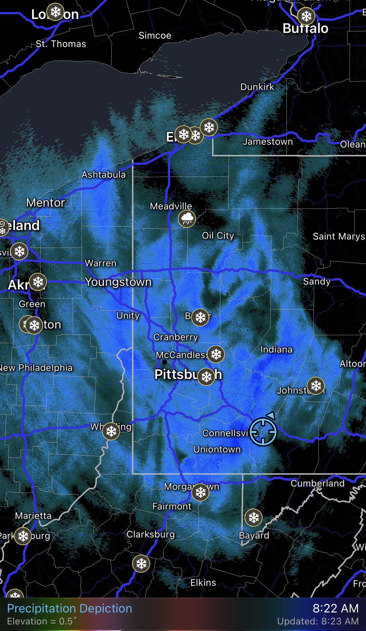
Ecanem replied to meatwad's topic in Upstate New York/Pennsylvania
Current radar.
-
Western PA/Pittsburgh Winter 2021/22 Discussion
Ecanem replied to meatwad's topic in Upstate New York/Pennsylvania
If it makes you feel any better. It’s sleeting almost all the way up to Cleveland. -
Western PA/Pittsburgh Winter 2021/22 Discussion
Ecanem replied to meatwad's topic in Upstate New York/Pennsylvania
These radar apps are all just guessing. -
Western PA/Pittsburgh Winter 2021/22 Discussion
Ecanem replied to meatwad's topic in Upstate New York/Pennsylvania

-
Western PA/Pittsburgh Winter 2021/22 Discussion
Ecanem replied to meatwad's topic in Upstate New York/Pennsylvania
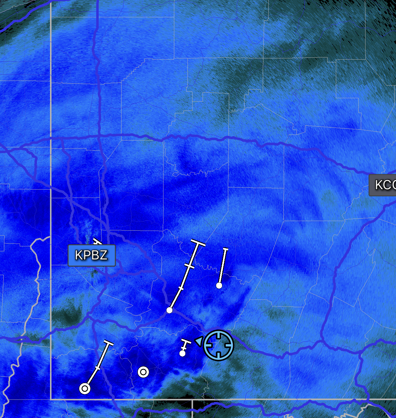
Massive band moving north. My worry with seven springs was the dry slot because how close it was to the low. We are drying up here. -
Western PA/Pittsburgh Winter 2021/22 Discussion
Ecanem replied to meatwad's topic in Upstate New York/Pennsylvania
Hard to measure from blowing snow. Probably 3”-4” at seven springs. -
Western PA/Pittsburgh Winter 2021/22 Discussion
Ecanem replied to meatwad's topic in Upstate New York/Pennsylvania
It’s ripping here. https://imgur.com/a/kypmV25 -
Western PA/Pittsburgh Winter 2021/22 Discussion
Ecanem replied to meatwad's topic in Upstate New York/Pennsylvania
Radar looks like wv turning to snow. https://imgur.com/a/rpzyx1b