fluoronium
-
Posts
226 -
Joined
-
Last visited
Content Type
Profiles
Blogs
Forums
American Weather
Media Demo
Store
Gallery
Everything posted by fluoronium
-
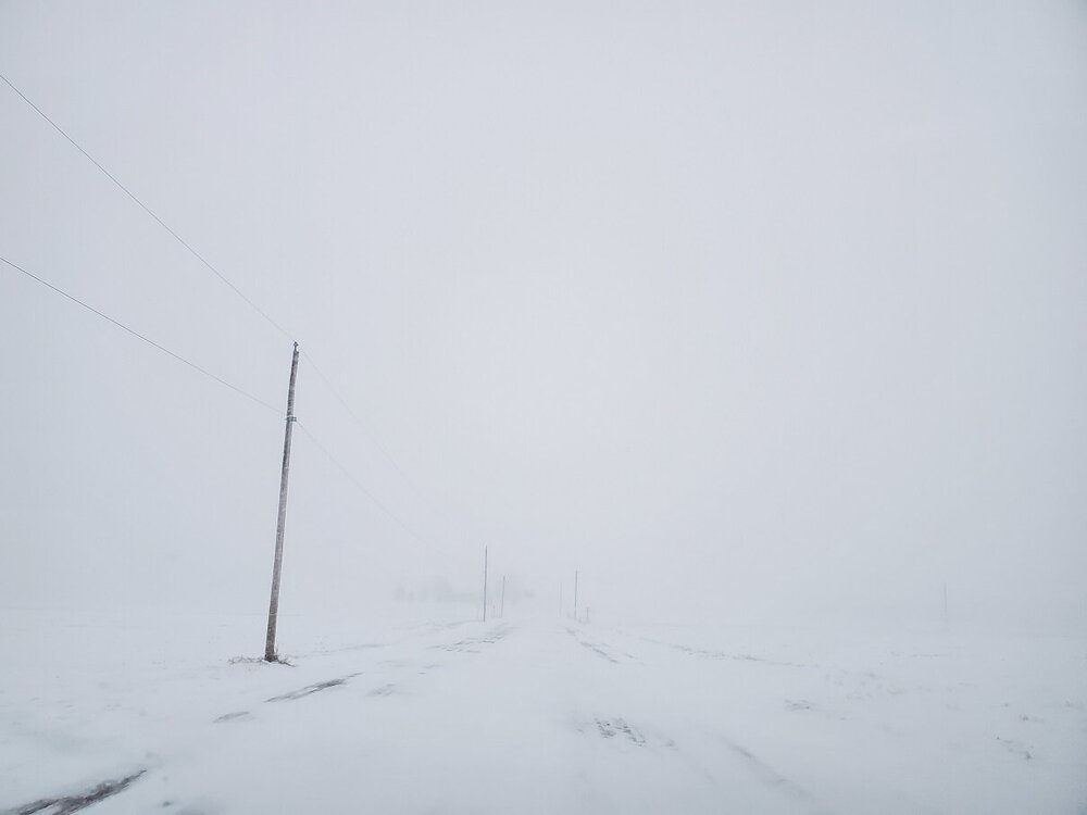
I chased the death band of snow to somewhere between Pontiac and Kankakee and it was INSANE!! It was scarier than most tornado chases I've been on since it was very difficult to keep my vehicle on the road. 2"+/hr rates and screaming winds with multiple rumbles of thunder. It was great.
-
weenie mode activated (but forever damaged from the christmas bust)
-
2023 Short/Medium Range Severe Weather Discussion
fluoronium replied to Chicago Storm's topic in Lakes/Ohio Valley
I didn't end up chasing Iowa on Monday since there wasn't the model uptrend in moisture that always seems to happen with these cold season events. Of course, it still dropped a wedge. These cold core setups almost never look "good" but man do they manage to produce. Looks like Ohio is next up in the cold core gravy train. I won't be chasing you know that silly parameter space is going to do it. SPC is even giving it a D2 slight!! -
Absolutely, and I welcome it. Don't get me wrong, I love snow, but a photogenic tornado under a crisp winter supercell is hard to beat. It seems you can't buy a good chase day in spring here, so I'll take what I can get.
-
2023 Short/Medium Range Severe Weather Discussion
fluoronium replied to Chicago Storm's topic in Lakes/Ohio Valley
Another opportunity for cold core tornadoes? Why the hell not? No interest from the SPC yet, but I've already got my cameras charging.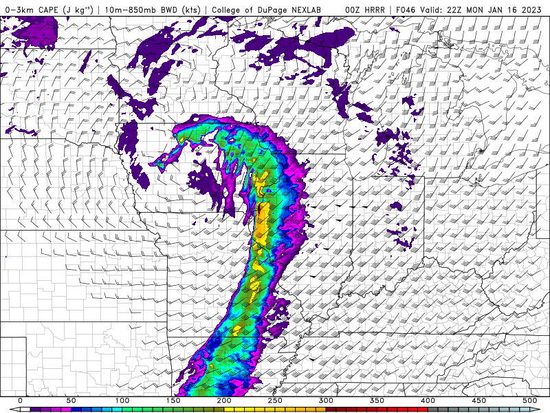
-
2023 Short/Medium Range Severe Weather Discussion
fluoronium replied to Chicago Storm's topic in Lakes/Ohio Valley
January 3rd was one of my best storm chases ever! I saw multiple tornadoes, and got within 100 meters of the EF1 tornado that went through Maroa, IL. I also witnessed an anticyclonic funnel, as well as beautiful winter mini supercell structure. The lightning was great too! I love these Illinois troll days. -
2023 Short/Medium Range Severe Weather Discussion
fluoronium replied to Chicago Storm's topic in Lakes/Ohio Valley
Don't sleep on the opportunity for cold core tornadoes tomorrow. SPC is not interested but I think it's one of my best local chase setups in quite some time. When you get record warmth and moisture up here at this time of year, somebody's gotta pay for it.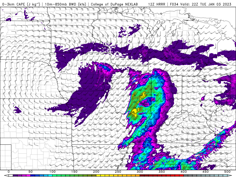
-
Winter 2022/23 Short/Medium Range Discussion
fluoronium replied to Chicago Storm's topic in Lakes/Ohio Valley
Upcoming torch is looking really nice about now. A lot of areas are going to get much needed rainfall.
-
Pre-Christmas (Dec 21-23rd) Winter Storm
fluoronium replied to Chicago Storm's topic in Lakes/Ohio Valley
weenie mode activated -
What is your favorite weather day of all-time?
fluoronium replied to Hoosier's topic in Lakes/Ohio Valley
I'm still salty about this day. (october 11 that is) I got trolled by some linear garbage with weak couplets to the southwest. I was out of range when that minisup fired and flew towards roanoke, even though it was closer to where I was living at the time than where I was chasing. As for my favorite day, that's a hard choice. I saw 7 tornadoes on august 9, 2021 so that day is up there. GHD III was great though because I bought my dream property because of it. The snow kept others from visiting so I could put in an offer and buy it without going into a bidding war. -
Brutal going directly from beautiful warm temps to CAD season without any exciting event in between. That stretch of nice weather was great though and I got a lot done in the yard.
-
^ I saw this run and immediately conceded to weenie season. I wouldn't mind a redo of the Halloween 2019 snowstorm. Fall colors plus fresh snow is hard to beat.
-
this storm was preceded by a huge tornado outbreak (for January) which makes it the ideal snowstorm for me too https://www.weather.gov/dvn/01241967_tornadooutbreak
-
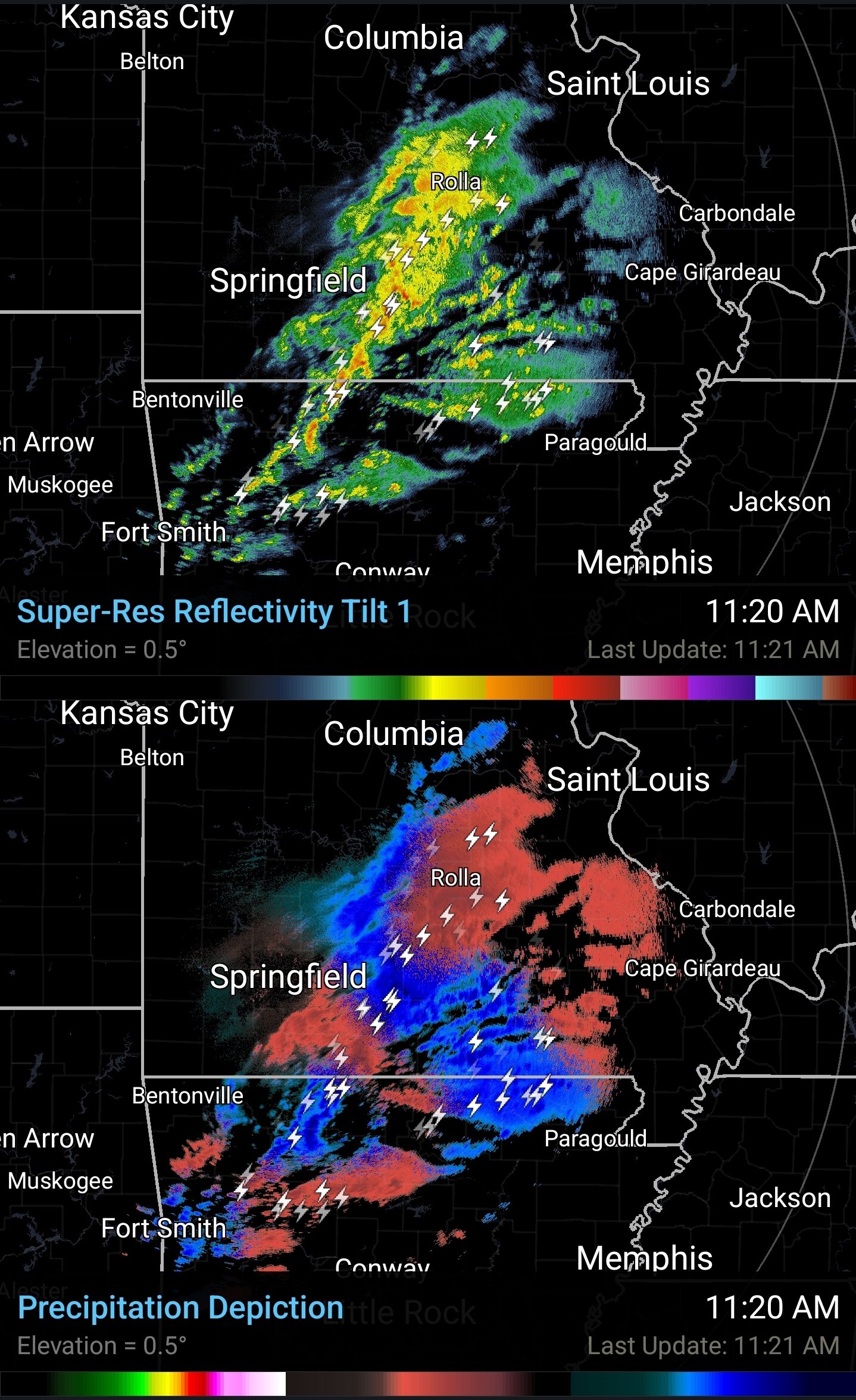
Lots of lightning over arkansas and missouri with the snow and ice.

-
Solid chance for severe weather on twosday in the southern parts of this subforum. I'd love to start chase season in February this year, and then follow it up with another snowstorm afterwards.
-
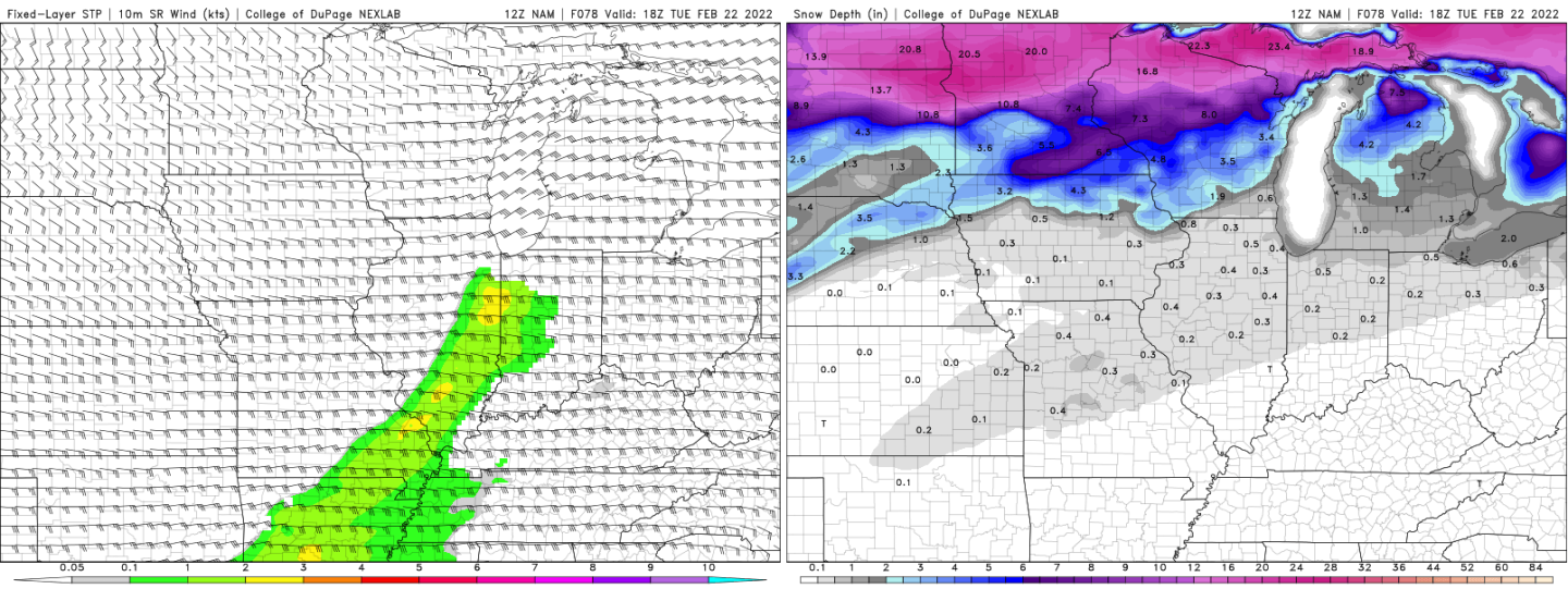
NAM casually suggesting tornado potential over areas with snow still on the ground

-
The snowfall rates in this storm were really impressive, although I have no idea how much actually fell due to the drifting. I can't remember the last time I've had two big snows just two weeks from each other. It's definitely nice to get some good winter weather after a snowless December and January. I love driving around when everything looks so frozen and desolate.
-
This final death band has been extremely impressive. Excellent finale to an awesome storm.
-
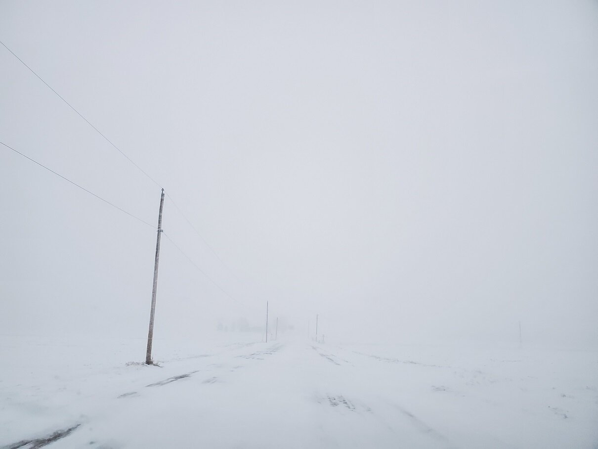
It's impossible to make a good snow depth measurement due to all the drifting. The snow hit full force around 10AM and it hasn't let up in since. Even if official totals end up lower than GHD 3 here, this storm is going to be a lot more memorable due to the crazy snowfall rates and the bulk of the snow falling during the day.
-
Graupel mixing in after being snow all day. I'm hoping this means I might get some thundersnow after all.
-
Absolutely dumping pixie dust right now. Heaviest snow rates of the season for me.
-
I'm sitting pretty much in the bullseye for snow totals right now. It would be crazy to get two major storms back to back in just two weeks. I've seen places to my north get hammered repeatedly in recent Februrarys so it's nice to finally cash in on the snow train! The icing on the cake would be thundersnow, but it seems models have down trended the instability as the storm gets closer.
-
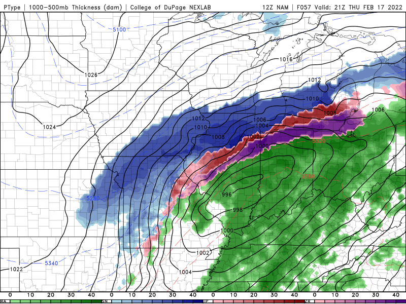
06Z NAM still had good overlap of instability in areas receiving snow and sleet. I'm really hoping we get some thundersnow out of this. I'm willing to drive to see it if it doesn't happen directly over my area.
-
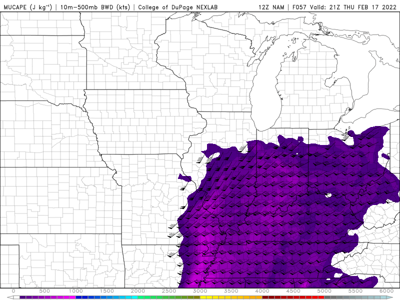
What do you look for on a forecast sounding to identify thundersnow potential? I see the NAM has mid level lapse rates in excess of 7C/km and MUCAPE values over 100J/kg in areas receiving frozen precip. There is a lot of shear as well. Is there anything else to be looking for?
-
NAM is quite generous with upright instability in areas receiving frozen precip. All of the models have substantial frozen precip rates regardless of where the storm ends up. Maybe there's a good shot at thundersnow somewhere with this???