

JakkelWx
-
Posts
3,373 -
Joined
-
Last visited
Content Type
Profiles
Blogs
Forums
American Weather
Media Demo
Store
Gallery
Posts posted by JakkelWx
-
-
made the wise decision to drive to bowers beach DE and got jumpscared by several close bolts. TONS of anvil crawler lightning. Flying through the sky everywhere like a plasma ball.
line looked weak back at my house so i made the quick decision to drive southeast and it paid off.
-
 1
1
-
-
6 minutes ago, Scraff said:
Hi I’m @JiWhere the hell are these afternoon soakers in January and February!?

Christmas eve 2025.
-
 1
1
-
-
17 minutes ago, WxUSAF said:
Getting grazed by that single cell in PG at my work
ETA…total gullywasher even without a flush hit. PWATs are juicy! @MatthewCappucci on Twitter showing this cell has a downburst signature on radar just to me southeast
Almost 38kft tops on that one.
-
Cell near charlottesville VA has a flash flood warning issued. It is barely moving at all. Almost 3 inches if not already.
-
1
-
-
2 hours ago, CAPE said:
Mid September.
Never-ending swamp ass with fries and a large diet coke.
-
3
-
 1
1
-
-
crazy light show right around sunset and after. one got way too close and sounded like bombs.
-
1
-
-
looking at the moon this evening for an unusually long amount of time. that was a looong party weekend.
-
that was a loud storm.
-
welcome to the swamps of dagobah!
-
2
-
-
storms have been constantly avoiding this location after a couple good hits earlier this month. time for it to reverse.
-
dover force field. THE STORMS WERE RIGHT THERE
-
1
-
-
I see two boundaries heading towards each other. one in southern DE and an outflow boundary crossing the eastern shore. Maybe this will fire up some storms here.
-
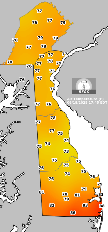
100/67 at KGED (Georgetown DE) at 1:35 PM
98/73 at 1:55 PM in KDOV. Almost there
-
the lava from yesterday has already remelted and its not even 10 AM yet
-
Just now, frd said:
100 here today, an inferno.
KDOV and KGED both hit 100 today! Dover surpassed the all time record of 98 set last year by 2 degrees. via extremeweatherwatch
-
 1
1
-
-
I go in friends pool around 3 PM. Pool is 88. I come out of pool to dry off. I start sweating in 3 minutes. I go back in pool. Repeat
I go back home, turn the sprinkler on at 8 PM. I run through the sprinklers and get my head all wet. I dry myself off in front of big ass fan. I step away from fan and start sweating again within 5 minutes. I do the whole process again 3 more times, then i finally decide to go inside.
-
1
-
1
-
-
43 minutes ago, MN Transplant said:
106 HI at the surface of the sun.
FYP
-
1
-
-
already a barn burner outside and its only 9 AM
-
Prepare to have your tastebuds slabbed.

-
1
-
2
-
 1
1
-
 1
1
-
-
3 hours ago, CAPE said:
Completely underwhelming yet again. 0.31" and a few rumbles of thunder. Maybe I can nickel and dime my way to half of normal rainfall for the month lol, although not much chance of anything over the 7 days. Currently at 1.6".
After baking for a week it will be desert-like here by next weekend
What the hell kind of "storm" was this? For an enhanced risk? Fork found in kitchen.
-
WHY do we keep doing this?
-
We need a classic night-time lightning barrage.
Did yall see that tornado in Somerset Nebraska today! Holy photogenic batman!
-
1
-
-
1.87"
0.10 in past hour. radar returns hanging on by a thread but ground truth is heavier. this reminds me of the back edge of a snowstorm when it sometimes re-fills in
-

After the storm
-
11
-
July Discobs 2025
in Mid Atlantic
Posted
score another lightning show and heavy rain! some loud booms. very impressive with how vivid and long lasting this lightning is, and how stifling it was right before the storm.
way better than last summer!