
Ian
-
Posts
43,737 -
Joined
-
Last visited
Content Type
Profiles
Blogs
Forums
American Weather
Media Demo
Store
Gallery
Posts posted by Ian
-
-
3 hours ago, mappy said:
Mr map got up early and has a brisket on for this evening. Couple friends and their kids are coming over to enjoy the pool.
Happy weekend!
Had dinner downtown with Matt and Randy last night. Doing some "normal" stuff is great.
-
 5
5
-
 1
1
-
-
3 hours ago, astarck said:
Missed it by a degree.
solid for low dews. should snag one or two in the days ahead if rain cooperates.
-
2 hours ago, MN Transplant said:
sweet
-
Highs locally...
DCA/IAD: 96
BWI: 98Highest of the year so far at Dulles and BWI. Performed or more based on modeling.
-
2
-
 1
1
-
-
Hopefully it's now hot enough for the people that live in the woods on a mountain or next to the water. Also good luck with the north trend this winter.
-
1 hour ago, WxWatcher007 said:

Yeah, that’s not gonna WHAT THE

we're not going to be that lucky in 2020
-
 4
4
-
1
-
-
1 hour ago, olafminesaw said:
Probably because it tends to reach criteria a lot for the region

Prob would be more useful to see them split here. May look into it but know that data is messy. LWX does a fine job overall but I think it is true they issue svr much more readily than pulling the trigger from advisory to warning. But it is prob partly a case of them following the criteria more directly for heat vs issuing svr for 40 mph winds since it'll bring down some dead trees. Plus the differences in office ideology matter so it's hard to compare across them. PHL gets way more warnings than we do with their special criteria as well, despite us looking like a hotspot.
-
19 minutes ago, MN Transplant said:
Goes out with a whimper at 87. Can’t fight the easterly fetch.
Better than 89. Also a fun day to watch the low level flow on satellite (time sensitive) https://weather.cod.edu/satrad/?parms=local-Virginia-02-96-1-100-1&checked=map&colorbar=undefined
-
what could have been...
-
19 minutes ago, pazzo83 said:
just too many clouds overhead all afternoon
we DCed the heck out of it
-
Just now, forkyfork said:
kinda lame to get all those 90+ days with no 100's. you don't deserve the record
yeah until it's 100 in a few days.. during our sad ass tiny streak
-
At least winter will make up for this failure.
-
1
-
1
-
-
21 minutes ago, forkyfork said:
back down to 86. i think the streak is done
The streak is dead, long live the streak!
-
1
-
-
3 minutes ago, MN Transplant said:
You know they would hold the climate report if it was close.
yeah maybe. I have seen it happen once or twice but I can't recall if it was summer. prob quite unusual this time of year tho a high near 5 certainly not out of the question on a day like this.
-
6 minutes ago, pazzo83 said:
i'd like to see an 87/88 at the 3pm ob, at least.
I want to see 89 in the daily climate report then hit 90 at 5:42.
-
1
-
-
1 hour ago, WxUSAF said:
Rain chances for tomorrow look paltry. Looked solid a couple days ago. Front timing earlier in the day seems to be the big culprit.
that has happened a couple times lately.
-
11 minutes ago, H2O said:
I’ll make my prediction now. Skies clear by 2 and temps soar. The 90° will happen around 4:30
Does look like it's finally making headway clearing from west to east. July the 16th be with you.
-
At least records are supposed to cluster right? #DCing
-
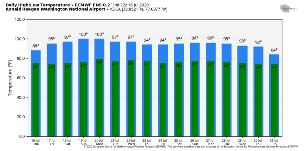
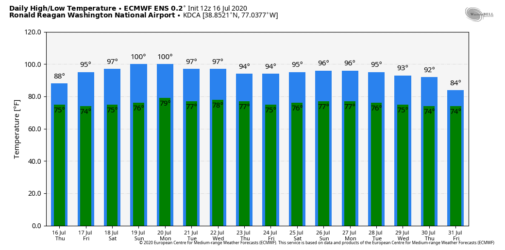
Euro has been increasing temps this weekend/early week lately. 102 for Sun and 101 for Mon at DCA per the 12z run. Closer in than many of the bigger numbers on display of late, though not total support.
-
1
-
1
-
-
20 minutes ago, pazzo83 said:
if we only drop to 75/76 tonight, maybe we get a boost.
nice snippet from LWX AFD... mentions the lows
.CLIMATE...
A rather notable streak of heat has been ongoing in the immediate
Washington DC area for nearly three weeks.

As of this afternoon, 20 consecutive days had reached at least 90 F
at Ronald Reagan Washington National Airport (KDCA). While it is
certainly not unusual to hit 90 F in July in the DC area, multiple
weeks without a break are relatively rare, as evidenced by the all-
time record which is 21 days (it happened twice in the 1980s -- once
ending on August 14th 1980, and again ending on August 18th 1988).
The ongoing streak is notable not only for its longevity, but its
earlier occurrence in the summer season.

If the temperature reaches 90 F on Thursday, the record will be
tied. But it`s going to come down to the wire.

While the background air mass will be warming, it will also become
increasingly humid. The more humid it is, the longer it takes for
the air to heat up (humid air is denser and requires more
energy to raise its temperature). In weather speak, 850 mb
temperatures will be about 1 C warmer than today, and 1000-500
mb thicknesses will be increasing several dm. But with the
increasing humidity will come a deck of clouds. These clouds
should lift and scatter by late morning and may actually help to
trap heat tonight leading to a warmer start. But if the clouds
linger too long, the air might not have enough time to heat up
to 90 F, especially at the airport with an onshore wind right
off the Potomac River (the water temperature at nearby
Washington Channel is 85 F).

Which of these competing factors will win out? It`s not clear just
yet, and probably won`t be until at least later tomorrow morning.
Guidance available so far today suggests highs will range anywhere
from 85 to 93 F at KDCA, with a best-guess consensus of 89 F. But if
it does hit 90 F tomorrow, it`s seeming increasingly likely it will
continue to hit 90 F for at least several more days after that as
the warming trend continues.
-
2
-
-
1 minute ago, MN Transplant said:
12z NAM was definitely warmer than yesterday's runs (87/88), so it is at least giving it a chance. The 12z HRRR looks like about 88 and the 12z GFS is 88 for IAD (the land surface scheme for the metro areas is exaggerating things). Euro as of the 00z run was still 91.
You are right though, an 89 would be the way we roll around here.
yeah somehow missed that one. just saw NAM MOS is 91 which seems about right. not sure why it would be all that much different than today. have had a fair amount of clouds today. NAM MOS also has 85 for Friday... we're having to earn this one.
-
11 minutes ago, pazzo83 said:
yeah now all we need now is a few 80F lows and we are all set
oh it's coming. we also kept the 70+ streak alive last night which seemed it could be close. american models still not a fan of tomorrow. national blend is 88 for DCA. would be classic #DCing. last night it was 91 for today -- will check back later.
")
-
2 minutes ago, pazzo83 said:
lol no doubter today - 90 at 1pm
we dominate summer
-
1
-
-
1 hour ago, pazzo83 said:
for the immediate DC metro, this is the new normal for us from late June-Aug:
highs in the low to occasionally mid 90s
lows in the low/mid 70sit's basically a similar climate to the NC piedmont, but we are more humid due to our proximity to water.
If anything our humidity seems to be increasing lately with proximity to warming bay/ocean etc. 94/78 on the reg woo. ;p

July Discobs 2020
in Mid Atlantic
Posted
This is that thing where LWX dots every i and crosses every t for heat products... 104 heat index sorry y'all. I get it but it is funny to compare to svr as noted earlier in this thread. Watch they'll fill it in overnight or something.