

RawCrabMeat
-
Posts
192 -
Joined
-
Last visited
Content Type
Profiles
Blogs
Forums
American Weather
Media Demo
Store
Gallery
Posts posted by RawCrabMeat
-
-
Lull here in Maryville. 4-5pm hour was pretty nice, getting dark. Need to see some more fat, quarter flakes soon.
-
Rain snow mix. Cannot get this thing to switch over.
-
Back to rain here. One of the worst days of tracking snow I can ever remember
-
It’s quit in Maryville. I don’t think it’s raining, but we need some snow bands through here badly
-
9 minutes ago, TellicoWx said:
Congrats to everyone who scored. Glad a decided to take a nap this morning...all rain here.
Nap sounds like a good idea right now, lol. somewhat hopeful for the afternoon bands
-
Just now, RawCrabMeat said:
Maryville is snow. Light to moderate. Am hoping for rates to increase but it’s an improvement from 11am, which was rain. The mix line is too close for comfort if you’re south of Knox imo
Should add that someone from Townsend was reporting all rain. Not that surprising
-
6 minutes ago, PowellVolz said:
I think us north of Knoxville is transitioning to higher ratio snow. The radar looks about the same but the flake size is smaller but the intensity has picked up. Hopefully this continues SE towards @Reb .
.Maryville is snow. Light to moderate. Am hoping for rates to increase but it’s an improvement from 11am, which was rain. The mix line is too close for comfort if you’re south of Knox imo
-
 2
2
-
-
Well, for what it’s worth, I’m seeing more flakes mixing in now. We’ll see if it stays around. It’s slick outside but only grass is white
-
3
-
-
1 minute ago, fountainguy97 said:
Honestly this couldn't be worse timing. Needed this overnight and it's a different ballgame.
Yeah, we had no mixing issues overnight just very light rates. As soon as 9-10am rolled around and the radar looked nice it flipped to sleet, then rain. What’s crazy is I’m about 10 miles from the line, at most. I’m assuming similar issues in sevier
-
Nice cold rain here. Man, I’m dumbfounded.
-
 3
3
-
-
1 minute ago, Silas Lang said:
Goodness. That's awful. Didn't think the rain line would make it that far up.
Temp here is slowly climbing. At 29 now. See if snow cover helps temps stay down and prevent melting.
Yeah, I don’t know what to make of it. Hoping for the ground to remain white at this point. Appears all of the NC border counties are getting blanked right now
-
Just now, Silas Lang said:
Nice! So it looks like most in the central valley have 3 plus at this point.
Any reports south of 40? Wonder where the heavy cutoff is.
Raining south of 40 in Maryville. Less than an inch and currently melting
-
2
-
-
Some sort of sleet/rain in Maryville. Looks like a total bust here unless it can somehow change back over. Was only snow a couple hours ago. I’ll have to find something else to do today.
anybody know if there’s a chance of switching back to snow in Blount?
-
Just now, PowellVolz said:
I really like David Aldrich and think he’s a good Met. He has several times in the past rolled with a forecast everyone else was afraid to do. That being said, this is tacky IMO.
.David is the goat
did you mean to post a link?
-
1
-
-
1 minute ago, RawCrabMeat said:
One of the best modeled systems days out, especially GFS imo
surprised it didn't overamp and head NW wth all that spring energy. Not the biggest snow ever, but just about ideal avoiding temp issues, energy transfers
Gfs pretty much had it by tuesday . I'll never get over that feb 2015 100 mile north jump into Kentucky with that 12" system
-
2
-
-
2 minutes ago, Carvers Gap said:
Yeah, I kind of thought its as cool to see the western TN snow streak. Some modeling just nailed that. Honestly, that amazes me that computer modeling can do that.
One of the best modeled systems days out, especially GFS imo
surprised it didn't overamp and head NW wth all that spring energy. Not the biggest snow ever, but just about ideal avoiding temp issues, energy transfers
-
2
-
-
13 minutes ago, Snownado said:
I bet most of your snow will be gone by tomorrow evening.
Yes, March snow lasts as long as cloud cover does lol
weve got a deep enough layer that a couple inches will stay around until Sunday, though
-
4 minutes ago, Carvers Gap said:
Some cool satellite photos. Snow banding is evident over NE TN, W NC, and SW VA.
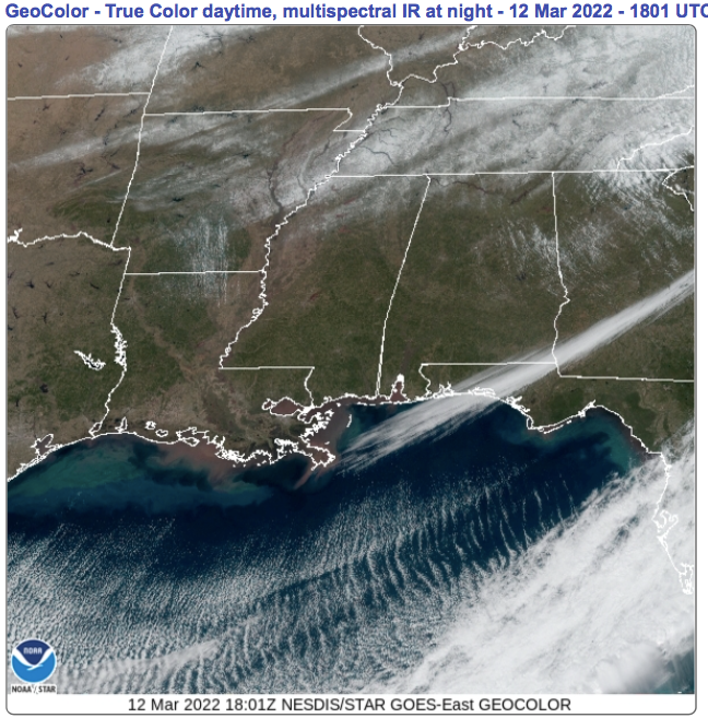
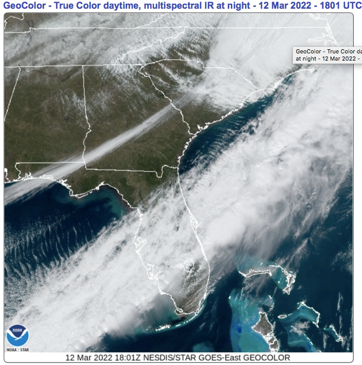
Cool image
looks like that sw/ne stripe in west tn missed out but most elsewhere got a hit, even chatt
-
2
-
-
11 minutes ago, PowellVolz said:
I’ve picked up another 1.5” from a roof effect snow band.
.I have a 0.5" on a table under a canopy
WATE got it!
-
2
-
-
-
3" down
off to bed
-
-
Pouring harder and another lightning flash
-
3
-
-
A little over 1"
-
3
-
February 2024 mid/ long range
in Tennessee Valley
Posted
Groundhog did not see his shadow. Now, I’m not one to argue with his omniscient wisdom, but I’m not sure I fully agree with the early spring prediction. I mean, multiple recent gfs runs have a snowstorm in northern MEXICO by the end of 384 hours, lol.