

RawCrabMeat
-
Posts
192 -
Joined
-
Last visited
Content Type
Profiles
Blogs
Forums
American Weather
Media Demo
Store
Gallery
Posts posted by RawCrabMeat
-
-
We're back to a mix...
-
Freezing a metal baking sheet at 0F. Gonna lay it outside on the deck once we get out of this dry slot. Wanna see how fast it sticks to it
-
Rates aren't enough to amount to anything here
-
2 minutes ago, Wurbus said:
Mixing with rain now here. Those were some pretty heavy rates earlier driving the big flakes coming down.
It was the weirdest thing. Not much came down but the flakes were snowballs
-
 2
2
-
-
2 minutes ago, bearman said:
We sure started early with the snow hope this is a good sign.
Yeah, can't be a bad sign, it's struggling to change over though, not amounting to anything yet
-
1
-
-
HRRR increases valley
-
2
-
-
Just now, brewman22001 said:
Huge flakes have started to fall in Lenoir City TN.
Same in maryville. Hope it holds
-
4
-
-
We're right on that edge, snow mix back to all rain back to some flakes
-
2
-
-
3 minutes ago, VOLtage said:
Wintry mix here in Maryville
Yeah, literally just changed to some flakes. There's some really heavy stuff coming in on radar
-
3
-
-
1 minute ago, John1122 said:
I'm probably going to make it to 6 inches or more with these bands. It's probably 15:1 or better. Very fluffy snow.
Let's see if we can get this band thru Knoxville all the way to Blount intact
-
2
-
-
Had some heavy band of snow/sleet going thru here, roads turning white
-
1
-
-
5 minutes ago, Stovepipe said:
We've got a slight dusting a mile south of Cedar Bluff. I can't imagine Farragut has much more.
I actually feel better about the goose egg here than some of the members here who reported nice snow changing to rain and melting
-
Just now, Stovepipe said:
Ground is whitening up some, temp down to 32. CC would suggest rain or mix but I'm all moderate snow. Maybe the slop is done?
Enjoy it, you've got me beat, green grass just south of you
-
Just now, PowellVolz said:
No reports of any rain or mix north of 40 in the valley and CC on RadarScope shows that well. We have talked for days that interstate 40 was the line.
.I was thinking about making an excuse to stay up in Knox, but didn't bother
-
1
-
-
Steady rain
-
 1
1
-
-
Just now, VOLtage said:
Oh well. I'm still happy with how the last system performed.
Some of us only got 1" then lmao... maybe this week already used up all the bad luck we can get
-
2
-
-
3 minutes ago, EastTNWeatherAdmirer said:
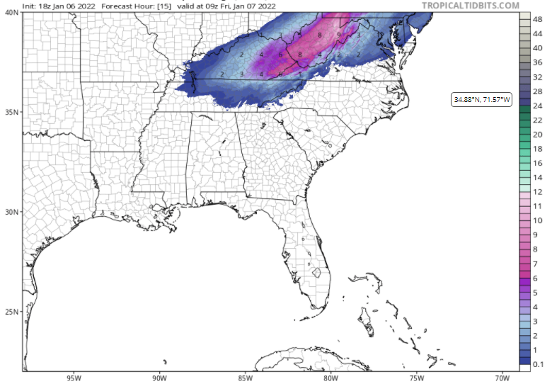
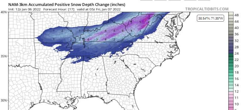
It appears a big time BUST could be in store for the East TN central valley and tri cities unlike the GFS, RGEM, CMC, Euro, some NAM runs, WRF's, showed only a short time ago. Latest NAM km, HRRR probably pretty on track with 1''-2.5'' for Maryville, East Knox, Jefferson City, Blaine, Morristown up through Greeneville and Johnson City. Warm nose really overperforming with rain to start at first for most in the central and NE valley. Wrap around moisture could provide a light dusting of an inch overnight. This is one of the most difficult systems I've ever seen. Really sad day for those in East tn who wanted snow
We're gonna get blanked. Maybe some black ice. Gonna have some coffee and take a hot shower. big time fail for the GFS
-
1
-
-
How's everyone enjoying their stay in warm nose cemetary
-
 1
1
-
-
4 minutes ago, nrgjeff said:
Athens reports are disheartening regarding the warm nose; however, this is a storm track issue more than an elevation issue. Athens is higher than Knox, but Knox is in a better spot relative to the storm track.
Radar in Middle Tenn is filling in better than I'd imagined. Still light, but not zero. Certainly it's better than the CAMs had depicted with the hard shut-off. North Alabama visible satellite is bumpier than I'd expected by now - a sign of continued lift or at least multi-layered clouds. Both trends are favorable where it's currently snowing.
For those in the warm nose, join me and the Dark Side. Let your anger flow through you. We Sith can hope for severe weather next time. This system would be a warm front tornado machine in March.
-
2 minutes ago, Icy Hot said:
Seems latest radar returns show dry air coming up from the south around Nashville area. Check and see if you agree. Dry slot is advancing.
Yeah, I'm not expecting much
-
1 minute ago, TellicoWx said:
Think you guys on the plateau and around Knox are golden..even HRRR has LP to The east in next 2-3 hrs. Backside on even it is showing more moisture, brings more of the southern valley into play are 3-4pm.
You think Maryville looks more similar to Knox or the southern valley/madisonville for this system
-
3 minutes ago, Hurricaneguy said:
40 degrees in Greeneville. Yall enjoy your snow. We'll make slush angels lol
Haha, about every system we get, it's easier to remember what robbed us rather than how much snow we got. In 2022 we already got WAA and not high enough rates, what's next? Spin the wheel and find out
-
1
-
1
-
-
16 minutes ago, John1122 said:
After being completely off the boat for the last two events, our old crazy cousin Ukie came for a visit.

https://c.tenor.com/WuOwfnsLcfYAAAAC/star-wars-obi-wan-kenobi.gif
-
8 minutes ago, TellicoWx said:
There is going to be a very sharp cutoff it seems along that southern edge...could be where 15 miles or so means the difference between sleet mess and 2"-4"+
Yep, looks like S valleys have a sharp line in their counties and the E valley has rain to begin, then snow, except for Chatt
Jan 16-17th Boom or Bust
in Tennessee Valley
Posted
https://c.tenor.com/2LRO8xWwmuAAAAAd/american-psycho-patrick-bateman.gif