

SnowGolfBro
-
Posts
1,556 -
Joined
-
Last visited
Content Type
Profiles
Blogs
Forums
American Weather
Media Demo
Store
Gallery
Posts posted by SnowGolfBro
-
-
7 minutes ago, leesburg 04 said:
3k nam says i'm a lucky punk
Maybe it’s not done correcting to the all snow pummeling. Bitterly cold still. 19/8
-
 1
1
-
-
Just now, MN Transplant said:
14.5 for the low. Coldest since the angle digit temps of late Jan 2019.
I was thinking it was the coldest night in a long time in Montclair. Thanks for putting a time stamp as i knew we had one really cold stretch but i couldn’t remember the exact date. 18/7 currently, clouds slowly streaming in.
-
16 minutes ago, pazzo83 said:
lol - DCA doin DCA things still
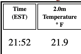
21.9 next a plane’s jet engine lol
-
 1
1
-
-
3 minutes ago, Snowchaser said:
HRRR
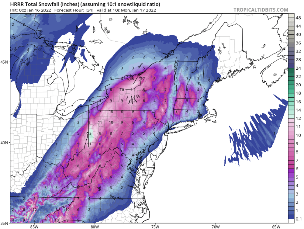
Hell yeah
-
The last ditch weenie hope for us lowlanders is a hot and heavy WAA slug that comes in like a wall earlier than expected and gives us 3-6. Posting this more for myself than the forum lol. 22/3 in Montclair
-
1
-
 1
1
-
-
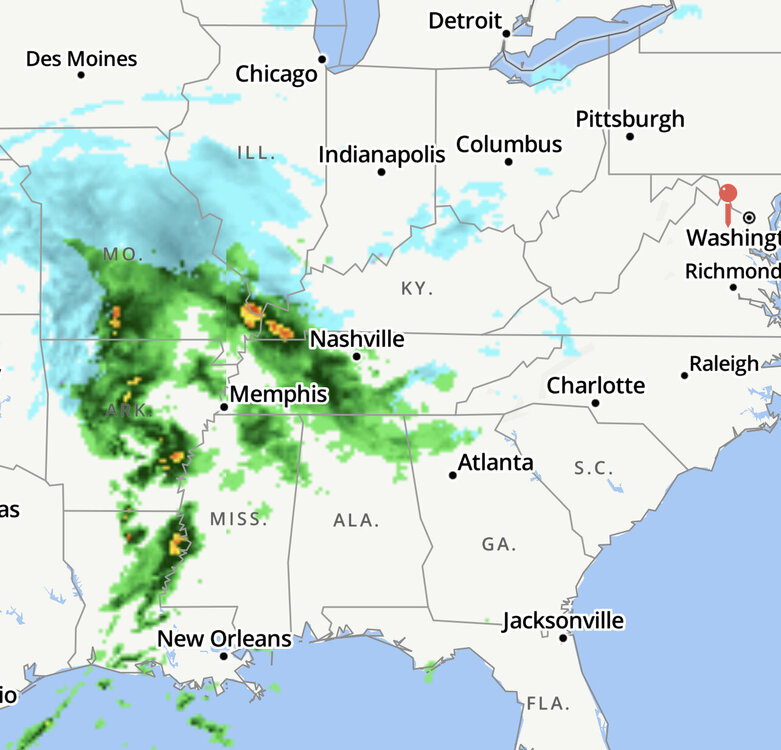
39 minutes ago, KAOS said:
This pretty much sums up the storm for those of us east of 95....

Shafted?!
-
7
-
-
26/1 in Montclair. Cloudy. Feels like rain lol
-
1
-
-
1 minute ago, LeesburgWx said:
Rocking 23 degrees and the radar is looking good!


Feeling good about this one.
-
1
-
3
-
-
Just now, Sernest14 said:
curious on how well the HRRR generally does?
Does decent in the 1-2 hour range. Past that….
-
 1
1
-
-
3 minutes ago, BristowWx said:
Do we get any ice? I say we because we are in similar locations
If this thing tracks like 50 miles east of that Euro track we get pummeled. I mix more than you in any situation. But 50 miles is all we need for a solid hit. Maybe 6-12 from east to west PWC.
-
21 minutes ago, Bob Chill said:
Reach arounds have happy endings, sometimes
If done right, every time.
-
1 minute ago, psuhoffman said:
I'll be at snowshoe for this one...so I am ok with these runs that are destroying WV lol
With this storm and the projected cold temps I think the ski resorts are going to be good for quite some time. Just spare us few inches
-
2 minutes ago, BristowWx said:
9.4 on that map in mby…done and done
PWC special!
-
1
-
-
11 minutes ago, Yeoman said:
Nevermind the low to the north
No doubt that feature is daunting. Time will tell. 72 hours until game time and 48 hours until all the players are in place.
-
Tenman knows his highs. I agree the models are overdoing the jump NW. not by a lot but just about 50-75 miles
-
2 minutes ago, stormtracker said:
The best part about this is that all 5 of these things are happening simultaneously. And that’s just at my desk lol
-
3
-
-
3 minutes ago, jaydreb said:
FWIW at this point. I guess GEFS just sucks for this storm?
Nice cluster off the Delmarva. Riding the GEFS until 12z tomorrow.
-
1
-
-
7 minutes ago, 87storms said:
it's an inland runner right now. no two ways around it. the antecedent high is in a good spot, but then moves offshore too quickly, for whatever reason. really need a less amped system.
The analysis is good based on the models. No argument there. But if this was showing a perfect storm track 90 hours out we wouldn’t be saying this is locked in. Well we might say it but we’d all be expecting the next model run to crush our dreams. This time I’m going to keep expecting the next run to bring home the bacon.
-
1 minute ago, BristowWx said:
the good part is snow is almost a lock of some amount for us..that amount is in question but flakes will fly for a bit...not too shabby considering I had the AC on at Xmas and NYE...both of which were warmer than memorial day in 2021...we've come a long way my friend
I had a foot and then 2-3 inches from the last two storms. After a week of mid 50s over Christmas in Canaan. 6 weeks of deep winter and ripping fatties is all I ever wanted lol.
-
Biggest GFS run of the year coming up. Baby steps. We stopped the bleeding, can we creep back toward a winning solution?
-
1 minute ago, Paleocene said:
Bit chilly sunday AM on the NAM eh?

It’s not just the NAM with the cold temps. To certain degree most of the guidance has shown a pretty stout cold shot before the storm dies whatever it does
-
1
-
-
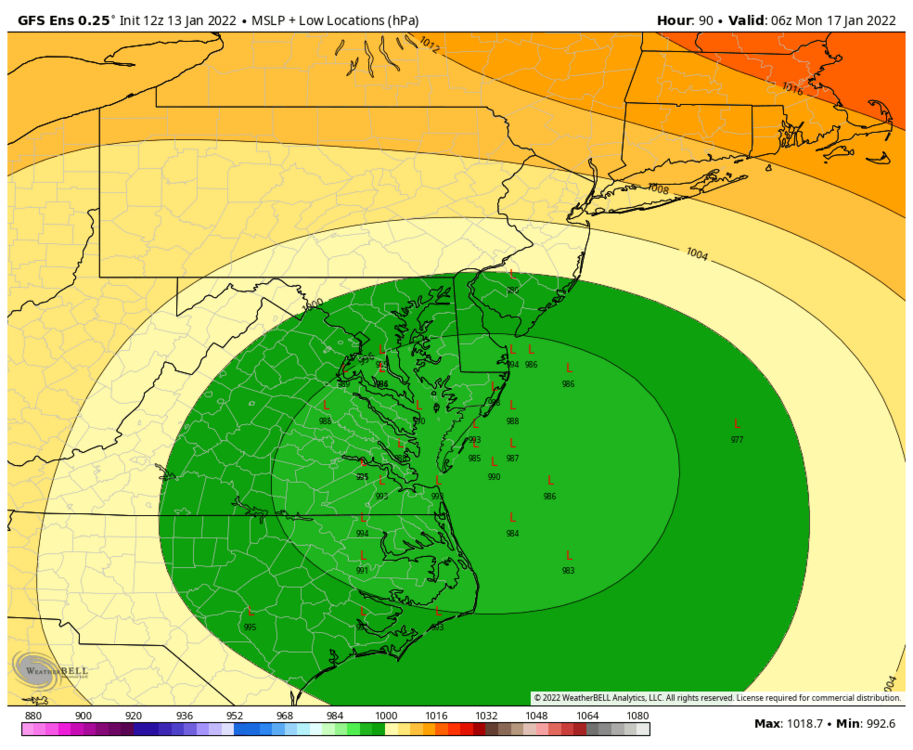
2 minutes ago, yoda said:
Well... 00z EPS also shifted west a tad compared to 18z... but:
All 50 of the members give DCA 2" of snow
Around 20 members would give DCA WSW criteria snow (5"+)
Any big hits in there? 40% chance of a warning level event ain’t bad
-
9 minutes ago, yoda said:
Bring it home Yoda!
-
1 minute ago, Ralph Wiggum said:
Around 84-96 hours the ens begin to not be as useful and we begin. Looking at the lr mesos.
If i remember correctly once we get inside that range the Ens typically more or less follow the op. Every once in a while they diverge inside that range and then maybe we take a look.


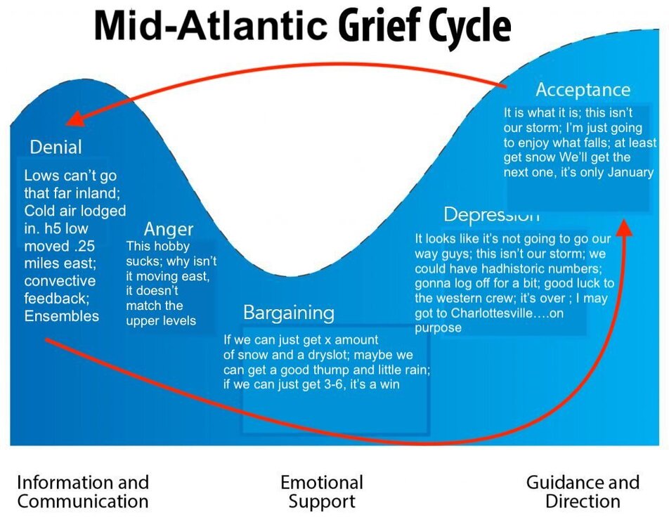
January 16-17, 2022 MLK storm obs/now cast
in Mid Atlantic
Posted
Snow starting to pick up a touch in Montclair. 24 degrees