

BTRWx's Thanks Giving
-
Posts
3,332 -
Joined
-
Last visited
Content Type
Profiles
Blogs
Forums
American Weather
Media Demo
Store
Gallery
Everything posted by BTRWx's Thanks Giving
-
Everyone who knows how. lol
-
The early precipitation falling overnight helps.
-
Bastardi was right all along.
-
Beautiful
-
You're so late.
-
They're not wrong.
-
Who is that?
-
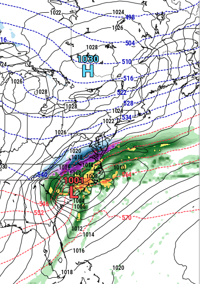
Look how far north the 540 is!
-
He was just mentioning how the model is being replaced.
-
-
I did notice a nice high placement on the euro even though the system was slightly to the south.
-
There's not a lot of time for the system to come much farther north. We're within 48 hours! Losing it south is the biggest concern.
-
Calling PSU! If this continues into tomorrow, let's get that zoom call scheduled!
-
That's a big run coming up!
-
That's la nina for ya!
-

January Medium/Long Range Discussion
BTRWx's Thanks Giving replied to WinterWxLuvr's topic in Mid Atlantic
-
We're saved!
-
December 2021 Medium/Long Range Discussion Thread
BTRWx's Thanks Giving replied to North Balti Zen's topic in Mid Atlantic
Even though ssta's to me look like 2011, one major difference is the MJO that December was closer to phase 5. Right now we're close to 7. If blocking develops as modeled down the stretch, then we could luck out. I also remember Bob Chill saying -NAO during the Fall is a good sign for NAO in winter. I'm still skeptical, but more uncertain. -
December 2021 Medium/Long Range Discussion Thread
BTRWx's Thanks Giving replied to North Balti Zen's topic in Mid Atlantic
That's not always the case. It's just some years the models are more chaotic. -
December 2021 Medium/Long Range Discussion Thread
BTRWx's Thanks Giving replied to North Balti Zen's topic in Mid Atlantic
It's kind of strange how the MJO is being modeled to race toward the null circle and then back out. -
December 2021 Medium/Long Range Discussion Thread
BTRWx's Thanks Giving replied to North Balti Zen's topic in Mid Atlantic
This comment might ruin the positive vibes about the long range, but I'm only going to mention my opinion here once. I'm skeptical that the MJO will cycle into phase 8, because the ensembles don't show much consistency. Back to lurking. -
December 2021 Medium/Long Range Discussion Thread
BTRWx's Thanks Giving replied to North Balti Zen's topic in Mid Atlantic
The basics are pretty simple if you use these two references and match the variable to the phase from the ensembles. Temperature: https://www.cpc.ncep.noaa.gov/products/precip/CWlink/MJO/Composites/Temperature/ Precip: https://www.cpc.ncep.noaa.gov/products/precip/CWlink/MJO/Composites/Precipitation/ -
Wednesday’s Amazing Event 12/8/21
BTRWx's Thanks Giving replied to SnowenOutThere's topic in Mid Atlantic
-
I have to be honest, I haven't looked at a single gfs run in quite some time. Focusing on just the euro reduces false hope.
-
December 2021 Medium/Long Range Discussion Thread
BTRWx's Thanks Giving replied to North Balti Zen's topic in Mid Atlantic
A sheared out mess


