

ams30721us
-
Posts
670 -
Joined
-
Last visited
Content Type
Profiles
Blogs
Forums
American Weather
Media Demo
Store
Gallery
Posts posted by ams30721us
-
-
Yea, I was literally just speaking with someone this evening, about how consistent the models have been with the mid-late week system, compared to all the other energy flying around before. But the midweek system, hasn't budged at all....and then tonight's run of the GEM and GFS both shifted southeast a good bit.
-
 1
1
-
-
Looks like two systems to watch over the next 7 days. The system Friday night into Saturday looks to be pretty moisture-rich but primarily looking more liquid than frozen, although some wet snow would be possible. I would be more concerned about potential flooding, with this snow pack and potential for any freezing rain, depending on if models are warming these temps up a bit too much.
It's still fairly early, but the one i'm keeping my eye on closely, is the one slated for Monday into Tuesday, which could be our next shoveling snow potentially.
It sure is nice to have plenty to track and watch this year!

-
Just looked outside to find more big, fluffy flakes coming down right now. The storm that keeps on giving!
")
-
10 minutes ago, cyclone77 said:

Interesting little tidbit from the DVN morning AFD.
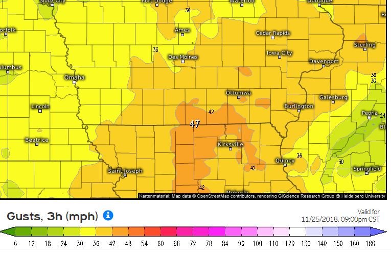
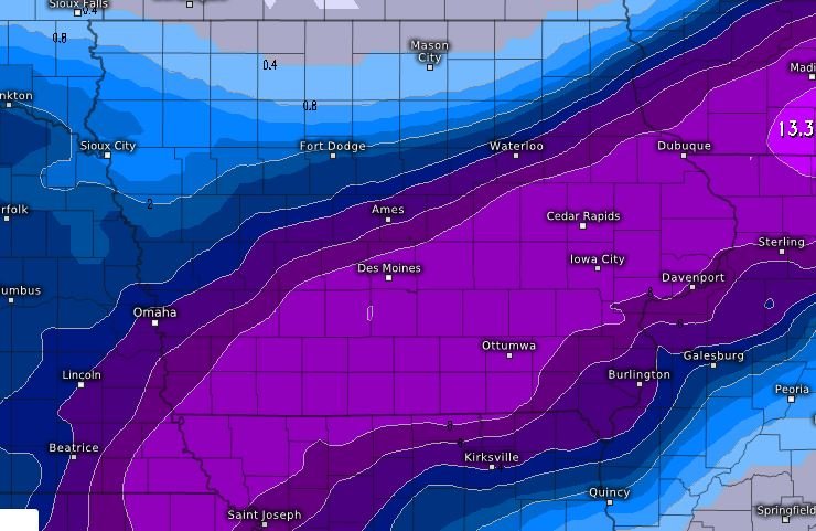
The powerful early season winter storm that produced blizzard
conditions (gusts of 40-45mph), a heavy snow band of 8 to 14+
inches, and quite a bit of thundersnow, is finally winding down.
Incredibly, some places near the Quad Cities had 0.75" of rain
before changing to snow, which prevented storm totals from
eclipsing 20 inches.
Here's the time lapse from the event. I decided to set a cooler out in front of the camera to show some perspective, as the red portion of the cooler is exactly 12" tall. Unfortunately I screwed up and didn't put it out far enough, so you can only see the top lol. Woops. I also shot a night lapse of the snow falling after sunset, but the falling snow made it so bright it blew out all the images.
One thing of note during the vid, you can see the snow actually melted a little bit during that 1.5hr lull after the changeover. I didn't notice that at the time.
Wow! That is awesome! I'm still trying to process this storm, but man was that amazing! I was starting to really sweat around Noon when we had not switched over, and we adding up those rain totals, and it was as if someone switched a flip. From moderate rain to now, and within minutes everything was white! Amazing! And we want even start with the snow drifts late last night!
13.8 officially now at MLI = The biggest November snowstorm on record. The biggest since the Superbowl Feb 2015 storm. Last year, we had all of a trace up to this date! So who's excited for Winter to begin in about a month?

-
2
-
-
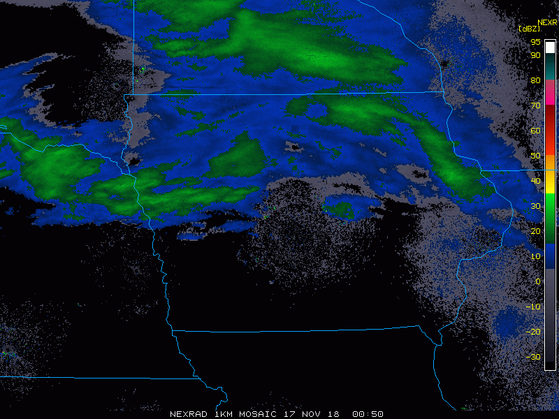
ALL snow the past 25 minutes here in DVN....Already white sheet on the ground!
-
1
-
-
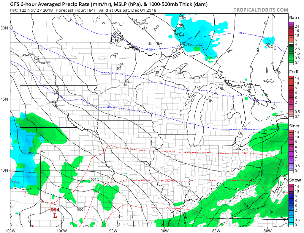
12z GEM also back a bit farther north
-
DVN:
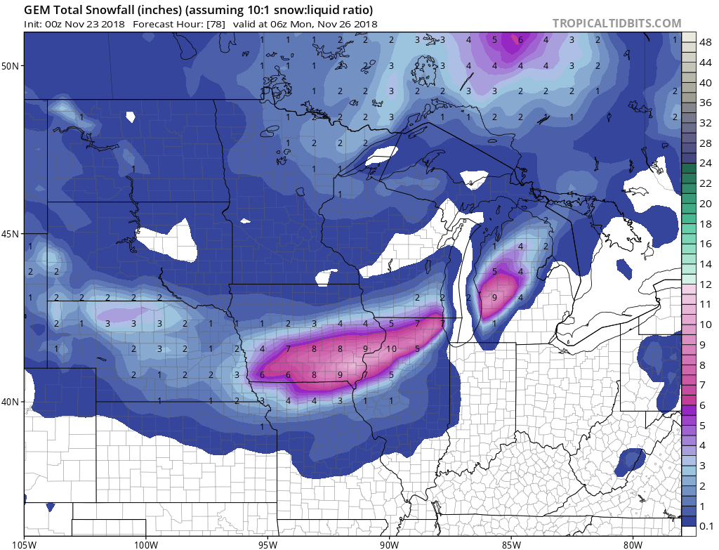
Quote.LONG TERM...(Saturday through Thursday) ISSUED AT 309 AM CST Fri Nov 23 2018 Main focus of the long term period is on the potential early season storm late Saturday night through Sunday night. Model trends/analysis: Much uncertainty continues with a general trend toward a southward shift in the heavier snow axis. The EC has joined the GFS in this shift, while the parallel GFS (GFSFV3) remains farther north. Heavy snow diagnostics, including Bufkit soundings, support heavy snow potential with favorable omega/DGZ profile. Can`t rule out brief period of freezing rain/sleet at onset, but temps aloft will quickly crash with dynamic cooling. Forecast adjustments: Slight shift to the south with slightly higher amounts. Highest amounts of 6+ inches currently favored in east central and southeast Iowa. Also increased wind speeds Sunday/Sunday night and potential for blowing snow. Confidence: Remains low with the system just coming on shore. Variations still possible in the track and intensity. Impacts/hazards: Potentially high with travel after the Thanksgiving holiday. Could see periods of very low visibilities with 1-2 inch hourly snowfall rates, resulting in very hazardous travel. Heavy, wet snow combined with winds could result in downed limbs and power lines. Headlines: Opted to go with a Winter Storm Watch for a large portion of the forecast area due to the uncertainty. Potential for 4 to 8 inch snowfall amounts in the watch area, although this is preliminary and additional adjustments will occur as forecast confidence increases.
IA...Winter Storm Watch from late Saturday night through Sunday
     evening for Benton-Cedar-Clinton-Iowa-Jackson-Johnson-Jones-
     Keokuk-Linn-Washington.

     Winter Storm Watch from Sunday morning through Sunday evening
     for Des Moines-Henry IA-Jefferson-Lee-Louisa-Muscatine-
     Scott-Van Buren.

IL...Winter Storm Watch from late Saturday night through Sunday
     evening for Carroll.

     Winter Storm Watch from Sunday morning through Sunday evening
     for Henderson-Henry IL-Mercer-Rock Island-Whiteside.
-
3 minutes ago, Stebo said:
That is looking more like a NW outlier especially once you get further east compared to everything else that has happened today.
Yea, I could def. see that further east. Around these, parts if I had to take a blend of the data over the past 24 hours, I would say the GEM is about how I would draw a map, in terms of the placement of the narrow swath at the moment.
-
00z GEM:
I-80 Special

-
Quote
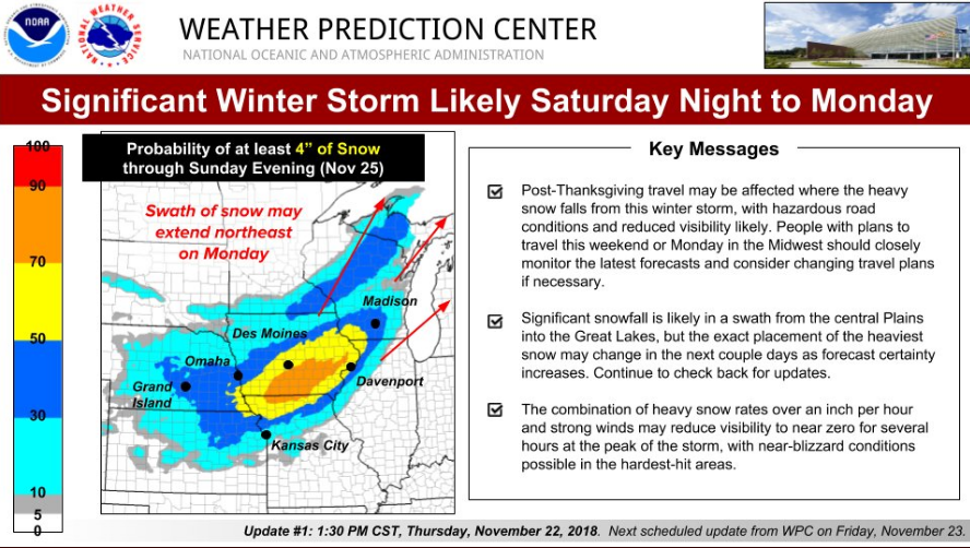
A significant winter storm may affect post-Thanksgiving travel Saturday Night into Monday across parts of the Midwest. A swath of heavy snow is likely, and the heavy snow is likely to be accompanied by strong winds. Continue to check for forecast updates, as details may change.
-
7 minutes ago, Hoosier said:
Yep. Even in areas east of the heavy snow totals, there could be a period of fairly intense conditions as that wind swath translates east.
True, and just looking at modeled temps, they are going to be in that 30-32 range, so the heavy, wet snow once again, looks to be the primary texture for sure.
-
Also for the QCA, looks like the new Euro joins the GFS/CMC in a faster flip to snow. Looks like anytime from lunch onward now, as opposed to waiting through Sunday night. In fact, temps look to only warm into the mid 30s or so now at best before the northerly winds kick in, and begin to cool the column.
-
1
-
-
11 minutes ago, ILwxchr said:
00z GFS and 00z Canadian model are in pretty good agreement of a storm track. 00z Euro has wind gusts approaching 50 mph on the backside of this low, which given the extremely packed isobars on the GFS, I'm inclined to believe that will happen and then some....Someone is going to see the "b" word out of this if we see that scenario. I haven't seen a snow map for the 00z Euro yet, but I'm guessing its similar to the other models if Hawkeye is looking at a foot of snow.....going to be a fun next few days.
I'll be in the QCA area until Tuesday morning, so this will be fun. Either I'll kill it or it will be an awesome time lol.
-
1
-
-
Whoa! Needless to say Sunday travel in the region is looking pretty rough at the moment. Yikes! 6"-12" snow totals along with sustained winds of at least 20-25mph and gusts 35-40mph, is going to create big problems.
Also, this year the cold has already been something else, but the New Euro is indicating a pretty wide swath of sub zero lows by Tuesday morning. Talk about looking and feeling like Winter around here. Of course, I have to remind myself Winter officially arrives in about 3 weeks!

-
5 hours ago, cyclone77 said:
This is a fun early season system to track, but one neg is this looks like it may be sort of a thread the needle type of an event. Looks like it could end up being a relatively narrow swath of potentially warning criteria snows, with not much else outside of the main swath. Also very little warm sector precip with this wave, which is in stark contrast to the wave that precedes it.
Yea, this will be a fun one to pin down for sure. The 00z GFS shifted the Upper low track farther NW, while the 00z Euro came out looking pretty identical to the FV3 GFS from last night in terms of track/placement and potential outcome.
-
1
-
-
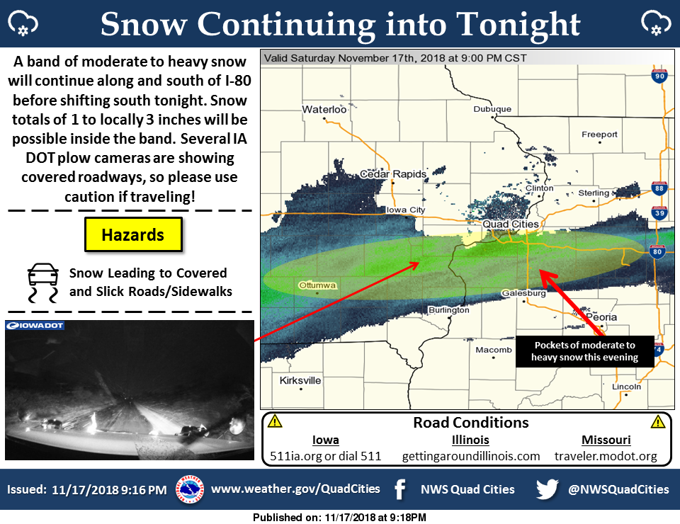
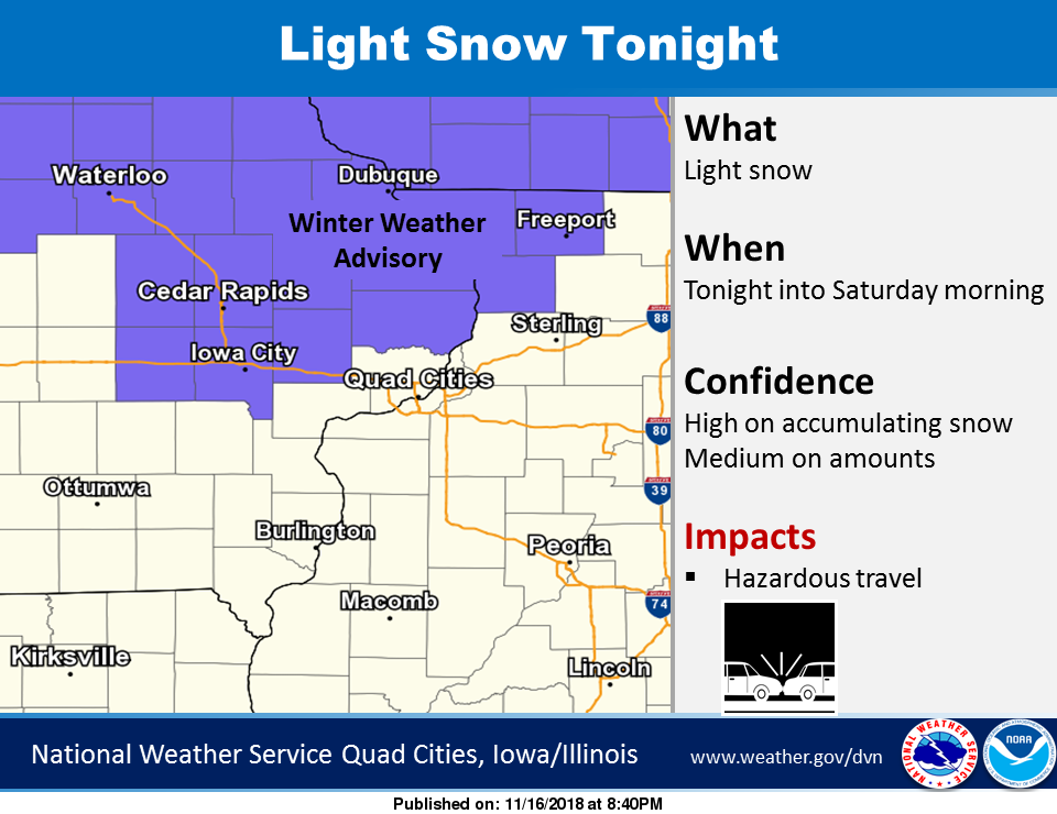
Welp, light to moderate snow has returned to the Quad Cities this evening. After that F-Gen band stalled near the Missouri/ Iowa border earlier.
-
1
-
-
WWA have been extended again further south to the Hwy 30 corridor this evening, as things seem to continue to be shifting south. Radar lightning up nicely back towards Ames, and Des Moines this evening.
-
1
-
-
If the 12z Suite has the right idea, WWA may have to be extended farther southwest, especially between Waterloo & Cedar Rapids. The new Euro coming in also seems to target that area with the potential a little further south.
-
27 minutes ago, CoalCityWxMan said:
It has also been consistently shifting a little south with each run. Last night it kept everything in southern MN/WI
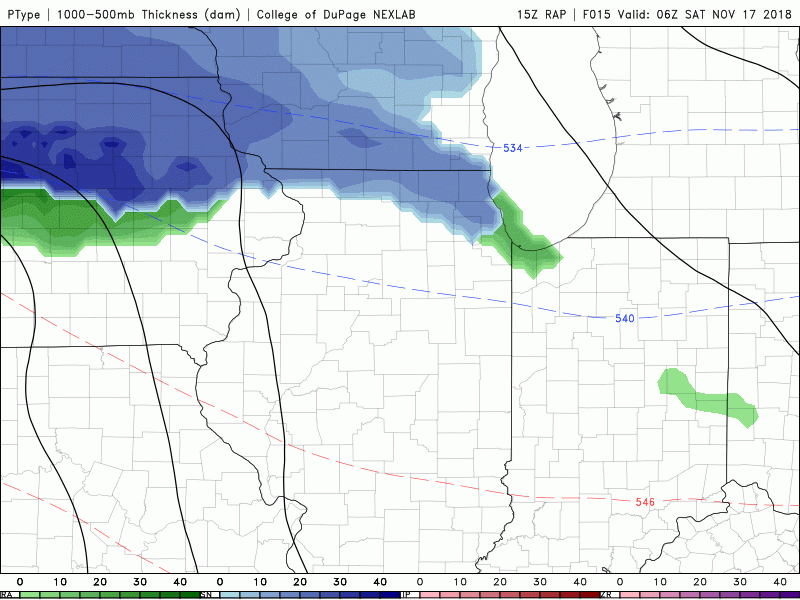
Yep, seems the 15z RAP is also trying to sniff out that convective band developing after midnight thru early Sat. morning.
-
1
-
-
10 hours ago, cyclone77 said:
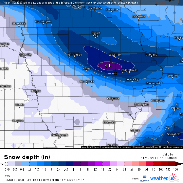
Still a little early, but the trends are to move the best snows from southern MN through southern WI with Fri night's wave. Looks like a DAB for about the southern half of the DVN cwa. Looks like 0.5-1.5" for about the northern third of the cwa. For here I'm guessing a quick burst of precip that starts out as a mix and transitions to wet snow and drops a few tenths.
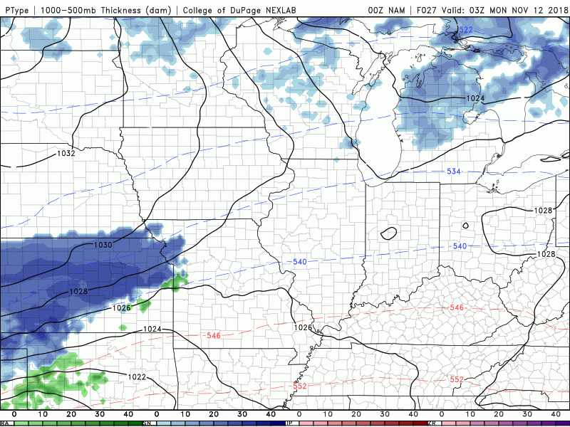
3km NAM showing some LES for Chicago Sat night that drifts into northwest IN by Sunday morning. Something to keep an eye on for you guys out that way.
Looks like this mornings hi-res runs of the RGEM & to an extent NAMs are trying to shift back a little further southwest, with more of a widespread 1-3 incher near the QCA. Still think around 1 on average, but something to watch the trends on.

-
1
-
-
1 hour ago, ams30721us said:
Wow! You're right about that. The NAM has really consolidated/shifted north through the day. Snow possibly falling literally just southeast of the QCA now, Sunday night thru Monday. If this thing can get a tad bit stronger w/ one more shift north, flakes may be flying once again! Or, it's probably just wishful thinking this far north, but I think Michiana is def. in play now!
FWIW the 00z RGEM also is trying to amplify/shift a bit to near the I-80 corridor on Monday. Nothing major but maybe a few flakes during the day.

-
41 minutes ago, Hoosier said:
This might be a case of the NAM overdoing things a bit but the 00z run gets precip pretty far north. At first glance it would seem kinda unlikely with the surface low being down around the Gulf coast but there is some decent mid/upper level support well north into Michiana, etc.
Wow! You're right about that. The NAM has really consolidated/shifted north through the day. Snow possibly falling literally just southeast of the QCA now, Sunday night thru Monday. If this thing can get a tad bit stronger w/ one more shift north, flakes may be flying once again! Or, it's probably just wishful thinking this far north, but I think Michiana is def. in play now!
-
47 minutes ago, cyclone77 said:
HRRR/RAP pretty consistent in showing around 0.15" of precip for the QCA. Looks like a solid inch on the way, with perhaps up to 2" in any areas that get under some better bands. Snow is about an hour or two away.
Yep, snow started here in DVN about an 1/2 hour ago, and already any elevated or grassy surface is completely white. Roadways initially are just wet. Look forward to a nice blanket by morning!
-
2
-
-
12Z Euro says, hold on it's gonna be CLOSE next weekend. At least something to watch. Arctic air, and precip! The last front did just plow thru the SE ridge giving the SE a storm.


Winter 2018-19 Medium/Long Range Discussion
in Lakes/Ohio Valley
Posted
Well hello there...