

ams30721us
-
Posts
670 -
Joined
-
Last visited
Content Type
Profiles
Blogs
Forums
American Weather
Media Demo
Store
Gallery
Posts posted by ams30721us
-
-
19 minutes ago, cyclone77 said:
The GFS and Euro have been showing this wave for several runs now. It doesn't look like some of the potent/dynamic systems we've seen as of late, but it looks like it could lay down several inches of fresh powder from Iowa points east. Still 90+hrs out, so let's see what kind of shenanigans the models pull with this one lol.

But seriously....what does your "warm layer" beam say right now!?

-
 1
1
-
 1
1
-
-
18 minutes ago, cyclone77 said:
Yeah it's been pretty wicked out there. Some chunks of ice keep breaking off the back trees and hitting the western windows. Sounds like someone throwing rocks at the house lol.
Yep, and this tree outside my window is making all kinds of crackling noises! I just hope it stays in one piece all night! Ha
-
2
-
-
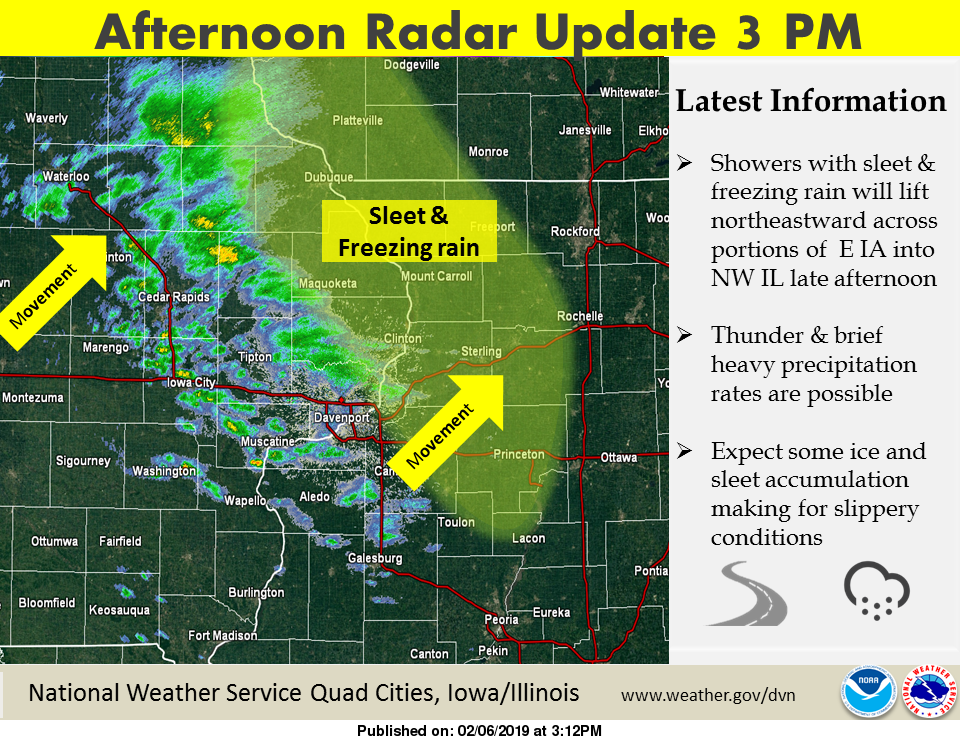
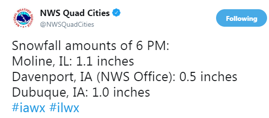
Impressive blowing snow this evening in the QC. Tough travel conditions along with roads becoming icy quickly after sunset. Winds gusting over 50mph at MLI, leading to numerous power outages and tree limbs down.
-
2
-
 1
1
-
-
28 minutes ago, cyclone77 said:
Yeah was just gonna mention this is a great look for northern IL on the GFS.

#rebuild the glacier


-
54 minutes ago, hawkeye_wx said:
A few thunderstorms are rolling through eastern Iowa this afternoon. I saw lightning and heard several rumbles, but the storm passed to my north.
Yep, had some more sleet here just a bit ago!
-
Still ended up with a good 1/2"-1" of slush on the roads and parking lots! Impressive, especially with Hi-res models backing off on amounts earlier today.
-
23 minutes ago, cyclone77 said:
Power went out for a few mins. Hope it doesn't go out for good. Glad the heaviest frz rain is almost done. It sounded like a summer night there for awhile. Most thunder from a cold precip event I've ever seen.
Yes, the amount of frequent lightning and thunder was really impressive! Heck, most of our recent warm, thunderstorm events didn't have that much of a light show!
-
2
-
1
-
-
Hvy Thundersleet in DVN! Sweet
-
4
-
-
5 hours ago, cyclone77 said:
And also thundersnow with that blizzard back in Nov.

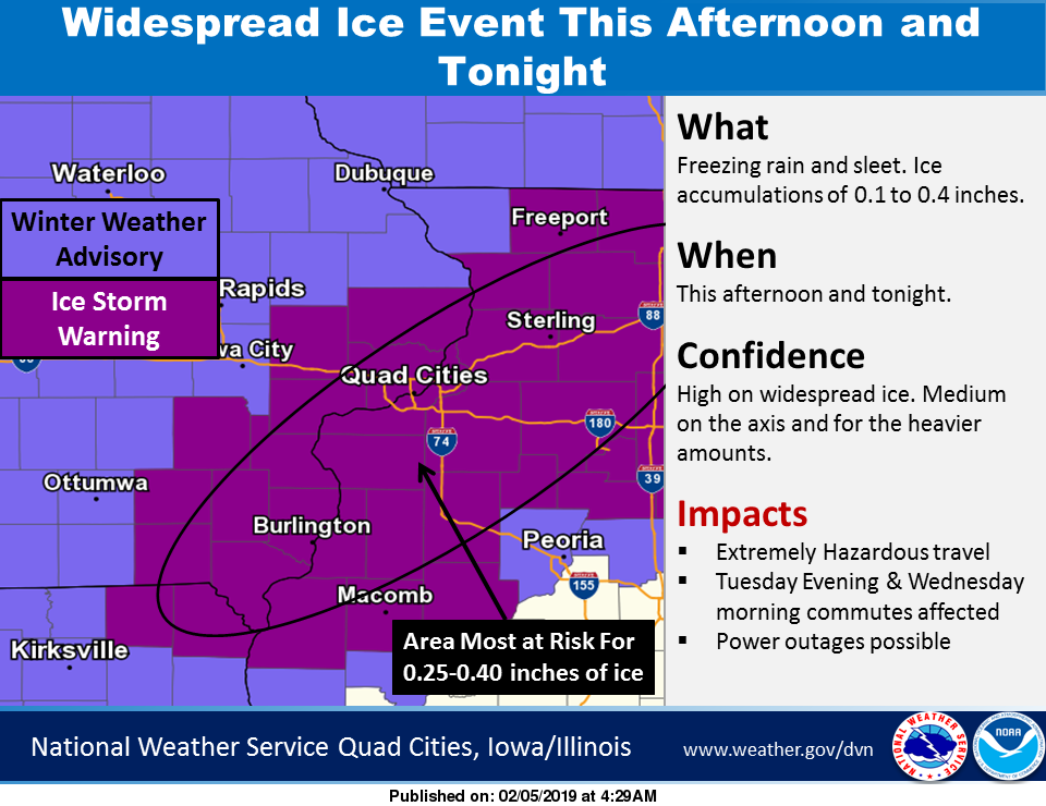
06z models and latest HRRR runs have scaled back quite a bit of precip for the DVN cwa. May have a tough time getting more than a tenth or two of glazing if those models are correct.
Yep, seems the trend continues with the 12z data. I can't complain about less Frz. rain though. Ha! Well any other Winter, maybe!

-
Well good morning. I can officially say, this Winter has just about brought it all the QC. Blizzard, Snowstorms, Record Cold, Very mild, w/ tornadoes, and now waking up to an ice storm warning.
-
1
-
-
40 minutes ago, cyclone77 said:
A couple interesting tidbits... Just two days ago MLI hit -33, and they are currently sitting at 46, which is 79 degrees warmer. Also, around this time two days ago it snowed all afternoon with temps well below zero. What a difference a few days can make.
Yea not to mention the lack of fog, drizzle, and low clouds considering all the snow melt taking place. Puddles everywhere!
-
2 minutes ago, cyclone77 said:
Yeah, and they weren't too far from the snowiest month, which was Dec 2000 @ around 32" IIRC.
Finished Jan with 27.7" here. Definitely an improvement in the 0.3" from December lol.
Yea, I'll say! It's hard to believe I was low-key panicking in late December!


-
8 hours ago, cyclone77 said:
Yeah it's been a nice little event. Pure fluff that you can clear off with a leaf blower. Stuff has to be at least 20:1 ratio.
Finished with 4.4" here, which was a few inches more than I expected. Now 19" on the ground, which is the most I've seen in any place I've lived.
Pretty cool that MLI got over 4" of snow on the same day they set the new all time record low.
Also believe MLI set the snowiest January on record of over 30.2"!!!
-
3
-
-
-22° New Record Low at MLI
-
1
-
-
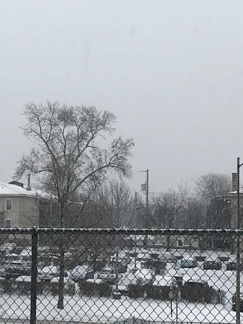
...and we're off with full blown steady light snow.
-
Fluffy flurries have started flying here. Should pick up over the next hour or two.
-
6 minutes ago, hawkeye_wx said:
The Quad Cities seem to do well in every storm. They got 12 inches back in November and seem to be getting 6+ from each of these smaller storms this month.
Actually 14.8" from the Blizzard...Lol, yea it really seems the 6"+ axis continues to pull us smack dab in the middle. This Winter has been pretty impressive from that standpoint. **knock on wood** I'll take it for sure.
-
Btw.. This Chicago split is pretty impressive to watch. What a fine line within about 20 miles.
-
Amazing to still be getting these Huge snowflakes, even when the returns drop off. Just beautiful out there this morning, of course now I gotta try to get to work in a little bit, so my opinion may change a bit! LOL
-
5 minutes ago, Chicago WX said:
MLI up to 37.6" for the season, thru 6:00 AM this morning. 50"+ season looks very doable/probable...which would make for a top 10 all timer.
1) 69.7" in 1974-75
2) 65.1" in 2013-14
3) 64.0" in 1978-79
4) 61.5" in 1959-60
5) 59.1" in 1996-97
6) 54.1" in 1971-72
7) 51.5" in 2007-08
8) 51.4" in 1911-12
9) 51.2" in 1969-70
10) 49.3" in 1925-26
Wow! Go big or go home, right! Heck at this rate me may make the top 10 by the end of next week!
") and that would include our nice 7+ week quiet/warm stretch.
and that would include our nice 7+ week quiet/warm stretch.
-
This will by far be my favorite storm of the season! Likely will end with totals between 7-9 inches total. Went to bed last night around 10pm with heavy wet snow falling, and awoke to heavy wet snow still falling a few moments ago, looking like a perfect snow globe scene. All of this after being modeled way to far south for any decent snow up through the final hours.
-
1
-
-
Whoa.. Heavy snow now in Davenport. HUGE Half Dollar Flakes, too!
-
2
-
-
1 hour ago, cyclone77 said:
All snow here as well after freezing drizzle all morning/early afternoon. About a half inch so far.
-
1
-
-
All wet snow now in DVN. Big Flakes! Covering everything nicely, already.
February 17th, 2019 Snow Event
in Lakes/Ohio Valley
Posted
In all seriousness, it does look like a decent setup for high-end advisory/low end warning criteria event. A nice west to east slider. Of course, i'm trying to reach the top snowiest winter and record coldest temperatures record in the same season at this point")