

ams30721us
-
Posts
670 -
Joined
-
Last visited
Content Type
Profiles
Blogs
Forums
American Weather
Media Demo
Store
Gallery
Posts posted by ams30721us
-
-
-
-
3 minutes ago, SchaumburgStormer said:

Oh my!

-
4 minutes ago, RCNYILWX said:
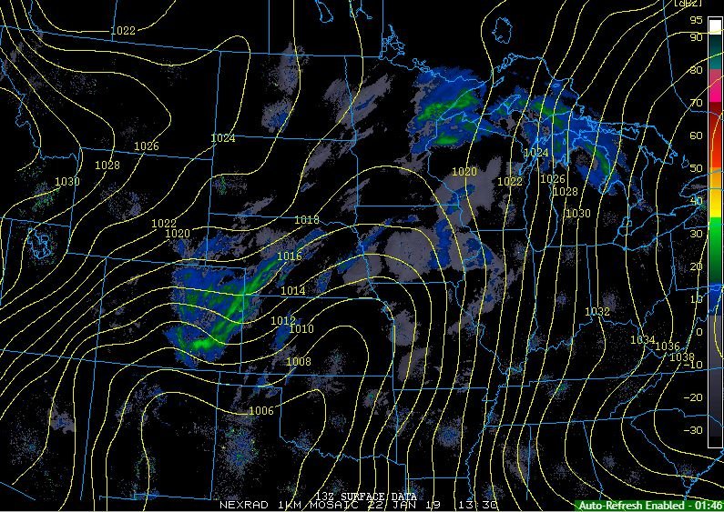
Key thing to watch today is the surface low position and strength compared to 12z guidance. According to our latest MSAS analysis, surface low center is at 1003 mb east of LBB Texas with pressure trough extending northeast into Kansas, 1006 mb to ICT area.
Sent from my SM-G965U using Tapatalk
-
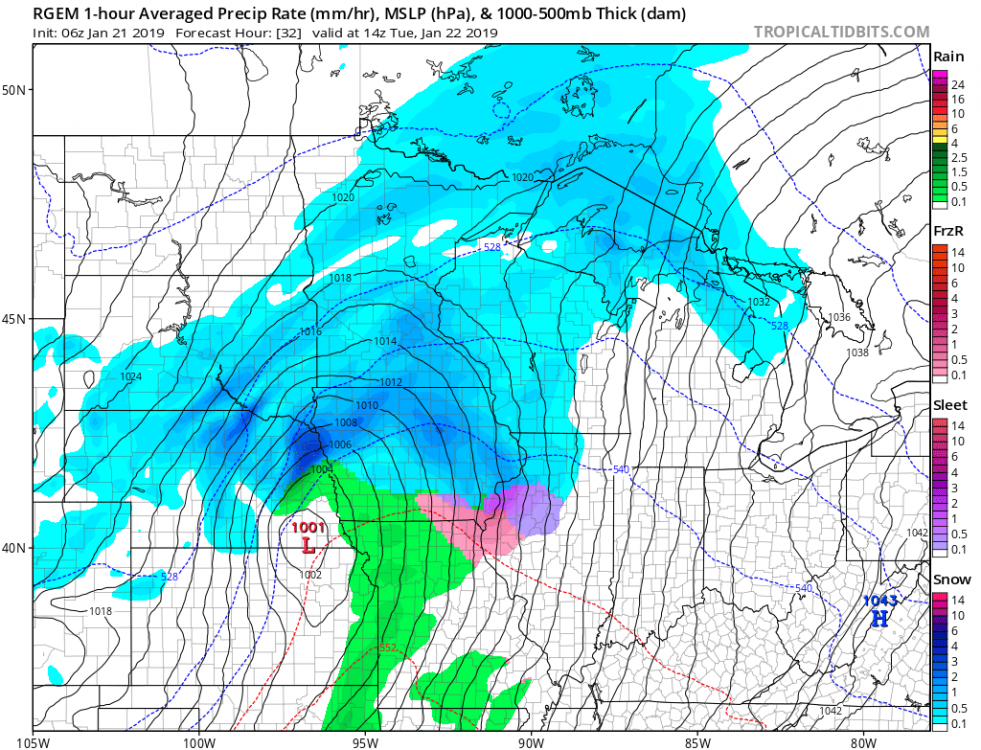
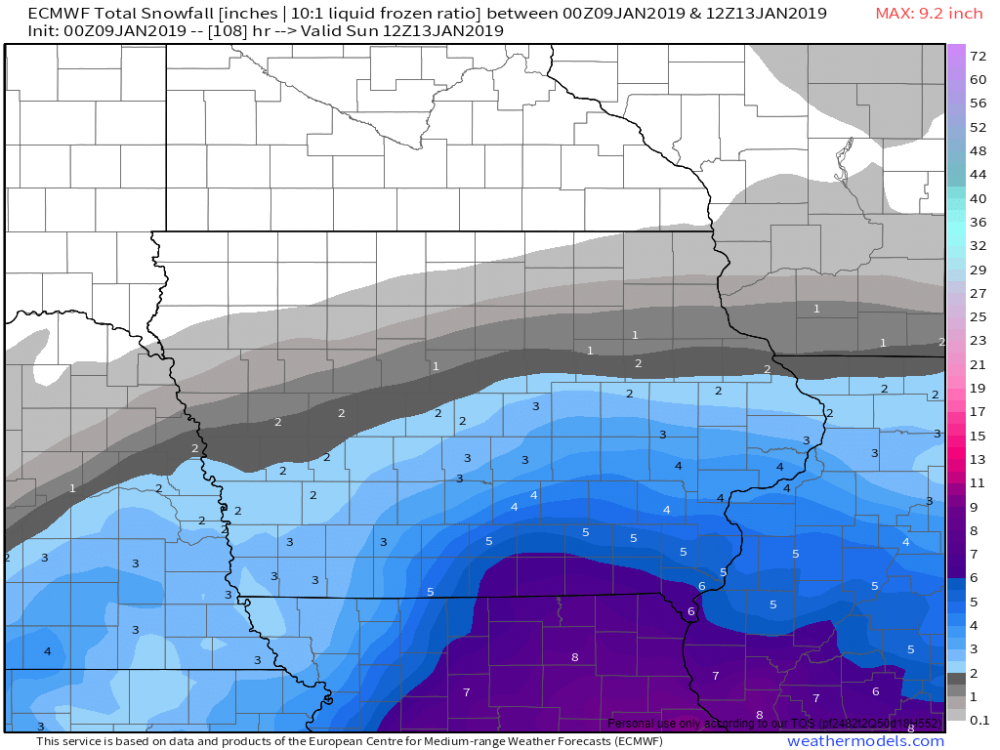
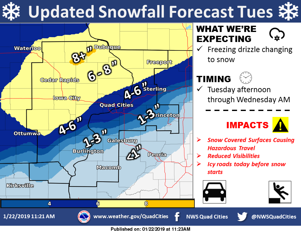
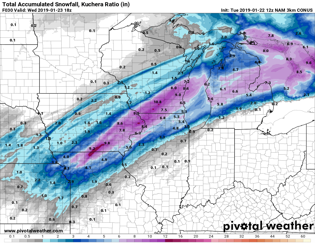
Yikes, just woke up to peak at the overnight data. Now looking more and more like a Icy mess today for the QCA with a bit of everything, followed by a few inches of wet snow overnight into Wednesday morning.
00z Euro now popping out 4"+ for the QC, although I would be inclined to believe more of a 1"-3" for the Metro itself, after a decent frz. rain and sleet early event. Just a mess.
-
Quote
National Weather Service Quad Cities IA IL
1129 AM CST Mon Jan 21 2019

.UPDATE...
Issued at 1119 AM CST Mon Jan 21 2019

The 12Z set of data continues to support temperatures near
freezing at the surface Tuesday morning, with rain indicated south
of Highway 30 aloft. That signal is enough that a winter weather
advisory is likely to be issued this afternoon for Tuesday morning
through the end of the storm.
-
This system is fairly complex, but its going to bring a moderate risk in my opinion of decent impacts for some locations.
For the Quad Cities, temps are below zero this morning, after hanging out below 20 all weekend, along with a very decent snow pack. Models are showing strong, warm air advection setting up, especially aloft, shooting temps from the teens Tuesday morning, to the mid to upper 30s Tuesday afternoon with precip arriving around Midday. My thinking right now, is a front end dump of snow to sleet/ frz. rain to possible plain rain by mid-afternoon if the warm advection is as strong as being advertised on the Globals.
However, my primary concern actually comes Tuesday evening into Tuesday night, in the form of a Flash Freeze in spots. Temps are also projected to drop from the mid to upper 30s during the afternoon into the low 20s by midnight, and well down into the teens by Wednesday morning. Even if all precip falls as regular liquid during the afternoon, the already frozen ground may not be able to absorb the moisture, and with temps plummeting during the evening & overnight hours, this could set us up for some very icy conditions Tuesday evening thru Wednesday morning.
-
Steady light snow beginning here in the QC now. Should be rocking by 9pm thru 2am around here!

-
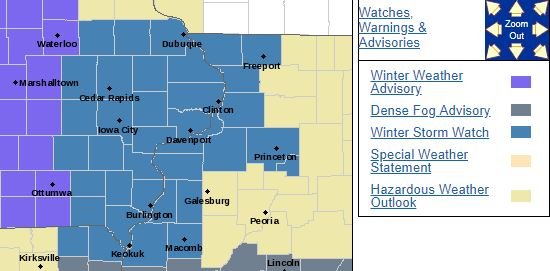
7 minutes ago, hlcater said:
Winter storm watches hoisted for DVNs CWA. Not sure who all is included but Linn and Johnson are.
 Quote
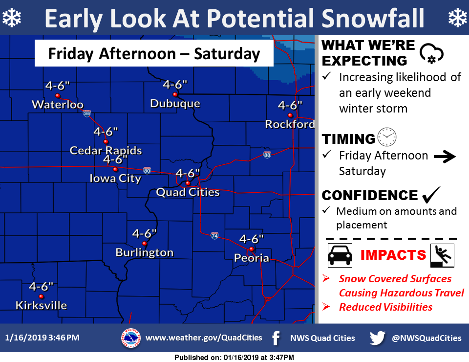
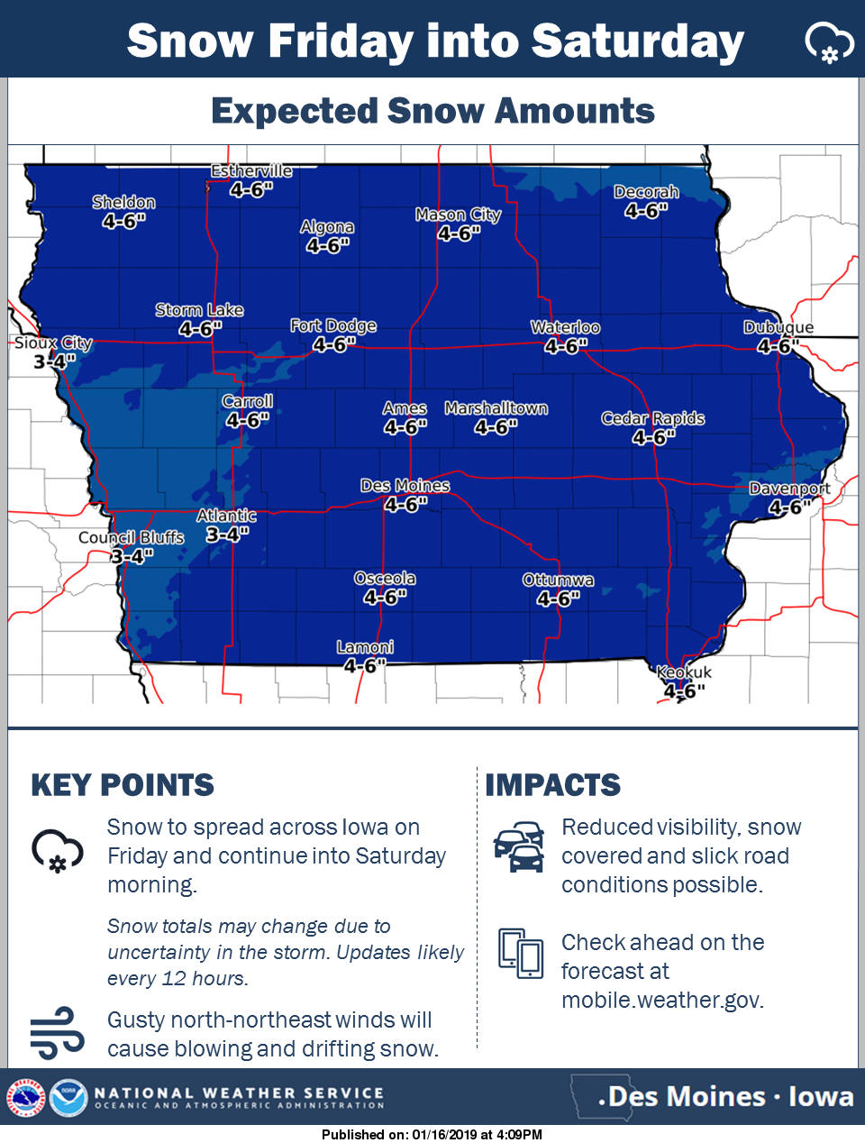
QuoteURGENT - WINTER WEATHER MESSAGE National Weather Service Quad Cities IA IL 1005 AM CST Thu Jan 17 2019 ...Significant Winter Storm to Affect the Area... .A significant winter storm will affect the area starting Friday afternoon and continuing through Saturday. Unlike the last winter storm, the snow from this storm will be of the dry, fluffy type. Additionally, winds will be stronger and will create drifting snow with some blowing snow possible. Snow/rain ratios will be increasing during this winter storm. Thus it is possible that snowfall amounts could trend higher over the next 24 hours. IAZ054-066-068-ILZ001-002-007-009-015>018-024>026-034-035-180015- /O.NEW.KDVN.WS.A.0001.190118T2100Z-190119T2100Z/ Jackson-Clinton-Scott-Jo Daviess-Stephenson-Carroll-Whiteside- Rock Island-Henry IL-Bureau-Putnam-Mercer-Henderson-Warren- Hancock-McDonough- Including the cities of Maquoketa, Clinton, Davenport, Bettendorf, Galena, Freeport, Mount Carroll, Sterling, Moline, Rock Island, Geneseo, Princeton, Hennepin, Aledo, Oquawka, Monmouth, Carthage, and Macomb 1005 AM CST Thu Jan 17 2019 ...WINTER STORM WATCH IN EFFECT FROM FRIDAY AFTERNOON THROUGH SATURDAY AFTERNOON... * WHAT...Heavy snow possible. Total snow accumulations of 4 to 6 inches possible. Storm total accumulations could exceed 6 inches. Drifting snow is likely with some blowing snow possible. * WHERE...Portions of east central Iowa and north central, northwest and west central Illinois. * WHEN...From 3 PM Friday through 3 PM Saturday. * ADDITIONAL DETAILS...Plan on slippery road conditions. The hazardous conditions could impact the evening commute. PRECAUTIONARY/PREPAREDNESS ACTIONS... A Winter Storm Watch means there is potential for significant snow, sleet or ice accumulations that may impact travel. Continue to monitor the latest forecasts.
-
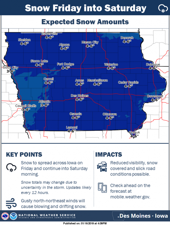
I think this is a good average starting point for around here. Let's see how things trend as we get some sampling going on Thursday.
DMX:
QuoteConfidence continues to increase in a widespread snowfall across Iowa from Friday into early Saturday. Blustery north to northeast winds are also expected and will likely cause visibility restrictions due to blowing and drifting snow, especially while snow is still falling. Behind this system very cold air is expected to surge into the state, wind chills well below zero expected by Saturday night.
DVN:
QuoteThe likelihood of a winter storm impacting the region towards the end of the week is increasing. At this time, snowfall amounts around 4-6 inches will be possible from Friday afternoon through Saturday, with the bulk of the snow falling Friday night. If you have plans to be out and about this weekend, please continue to monitor later forecasts!
-
-
46 minutes ago, Chicago WX said:
12z Uncle. Yes please.
 What a Beaut!
-
Another nice storm in the QC:
Moline: 7.0"
DVN: 6.4"
Even a healthy 2.0" in Dubuque. I was hoping to cash in that amount here in DVN just the other day.
As a southerner, I love these bigger snowfalls this Winter and last, but I always regret them when having to clear the car and driveway before work at 2am each morning! Ha
Well at least it's not too frigid!
-
 2
2
-
-
Lol! The QC Metro now added to the Winter Storm Warning. I;ve got a little over 6" here in Downtown Davenport with radar still looking healthy back to the west. Hard to believe this time yesterday I was hoping to average 3-3.5" here as a big coup. Haha
-
1
-
-
10 minutes ago, CoalCityWxMan said:
So did the Canadian FWIW

-
19 minutes ago, Chicago WX said:
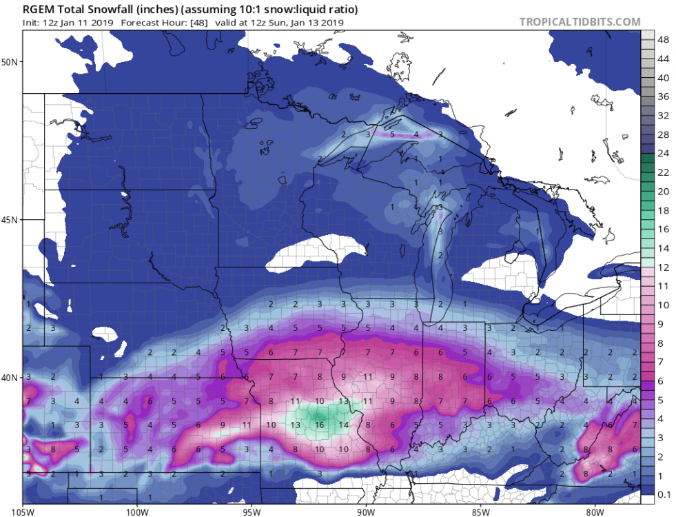
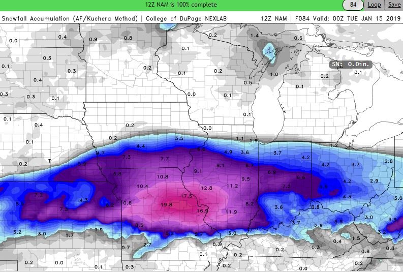
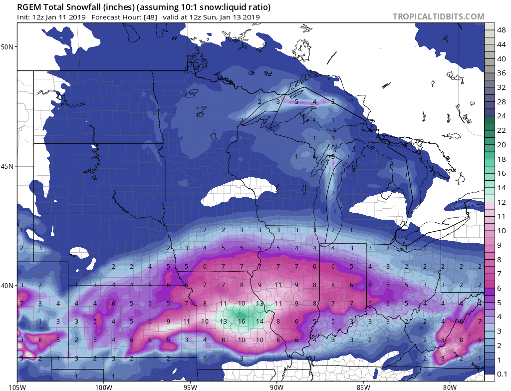
12z RGEM brought the 0.50” line north of IKK. That’s nice.

Yep, RGEM a little more juicy near I-80 also.
-
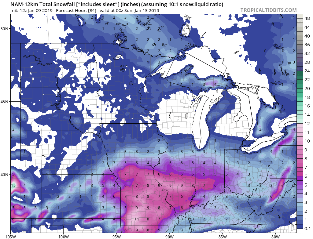
41 minutes ago, Chicago WX said:
12z NAM improved for quite a few. Brought higher totals northward for central IL, the QC,...and farther east for the IN and OH crews. Jackpot is just west/northwest of STL.
Yea, looks more like the FV-3. Brings heavier totals 3-5"+ totals right to I-80 corridor.
-
29 minutes ago, Thundersnow12 said:
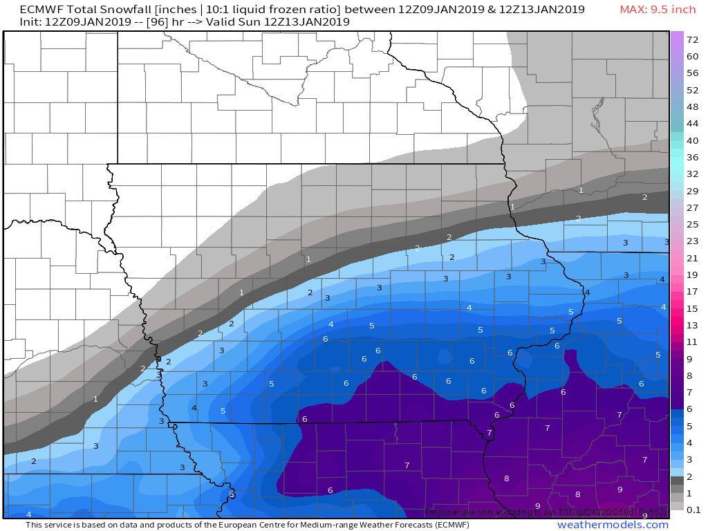
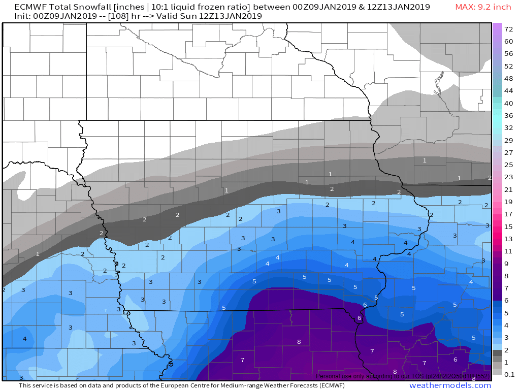
Euro even more impressive than 0z run. Get's 4-6" amounts into entire LOT CWA to the WI border.
Yep, numbers continues to increase for DVN CWA also.

-
2
-
-
Just glanced at the 00z Euro and it def. had a generous bump in potential numbers for folks along the I-80 corridor in IA & IL. More in line with the NAM. Let's see if these trends continue or we start to go the other way in future runs.

-
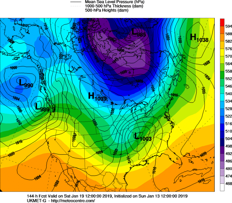
FWIW 12z Euro seems onboard with a system.
-
6 minutes ago, Hoosier said:
You can say this a lot but this system would be big trouble from an ice perspective if it were about 5 degrees colder. There's a zone with pretty good qpf where temps are progged to be like 33-35. Even if it were to hang around 32 longer than progged in that area (though there's not much reason to think that happens with this synoptic setup), the precip rates would probably be high enough so that some would runoff.
Yep, agreed. In fact temps have been off a bit in the models the past few days, leading to Friday's light freezing rain event here, and todays below forecasted temps. If trends of tonights 00z data continue through tomorrow mornings data set, i'd expect advisories to be issued for parts of central & eastern Iowa, and potentially northwestern Illinois.
Looks like a light glaze of ice during the morning commute on Monday, followed by the potential for a few inches of snow by the afternoon & evening commute, especially along & west of the Mississippi.
-
This new wave of snow moving in this evening in Davenport is pretty impressive, especially with all this wind. A nice little taste of Winter at least today.
-
1
-
-
Nice little surprise! It was in the mid 50s here in the QC when I went to bed last night around 10:30pm, and I just woke up to some freezing drizzle and a nice dusting of snow on the grass and car tops at 5:30am with WWA in place for today. Looks like maybe a little better chance of some snow showers late morning into early afternoon as a new disturbance arrives from the west.
-
Surprisingly, 00z NAM still pretty excited about spitting out some light snow for portions of the Sub Monday night into Tuesday.


January 21-24 Winter Storm Potential
in Lakes/Ohio Valley
Posted
Suprisingly, those heavier echoes Here in the QC are producing sleet & snow. I figured we would be Frz. rain to start for sure.