

bluehens
-
Posts
838 -
Joined
-
Last visited
Content Type
Profiles
Blogs
Forums
American Weather
Media Demo
Store
Gallery
Posts posted by bluehens
-
-
Radar looking progressively better to our southwest. Reports on the ground improving too. I am thinking by 6:00 we should be in solid snow for the remainder of the storm. I am located in far northern DE just south of Delco.
-
 1
1
-
-
1 minute ago, ravensrule said:
The state of Delaware approves this message
-
5
-
 1
1
-
 2
2
-
-
Heavy sleet again in Wilmington
-
Round 2 is a pipe dream for SEPA and northern DE. At best I think we get freezing mist. Everything pointed way way west and ultimately north.
-
1
-
-
We have 2 hours tops and then this thing is out of here.
-
2 minutes ago, Kevin Reilly said:
About to get demolished by that band coming up from the south in Media Delaware County wish I knew of its snow or sleet when it gets here.
Its heavy snow. I can confirm because its here now in North Wilmington.
-
2
-
-
Just now, Kevin Reilly said:
You so see what’s coming up from Baltimore and SW of Washington?
I am hoping that delivers for sure. I am just south of the Delco line in DE. My little 10 mile area of latitude has been the absolute snow anus this year. Just way too much sleet or just too far south of the heaviest bands. I knew this one would be trouble though and of course the sleet line has parked directly overtop of us. Heavier precip bringing more snow but as soon as it lets up it goes almost all sleet.
Can't complain though as this is our 4th legit light to moderate winter storm this year and I was expecting next to nothing again.
-
Radar looks like storm is flying. Maybe only a few more hours at best of precip.
-
1
-
 1
1
-
1
-
-
We all know this is coming north. EPS made move already.
-
1
-
1
-
-
Snow in WC at Iceline rink for early hockey game.
-
1 hour ago, Ralph Wiggum said:
Right? People should always wait until the event is completely over. Not saying anything more significant accumulates, but cancelling at the midway point sometimes isn't the best course of action.
Ralph this isn’t the midpoint. This is pity flakes for us to the south. This storm is over. Already drying up out there on radar.
-
2
-
1
-
-
It’s snowing harder now here than at any point yesterday.
-
1
-
-
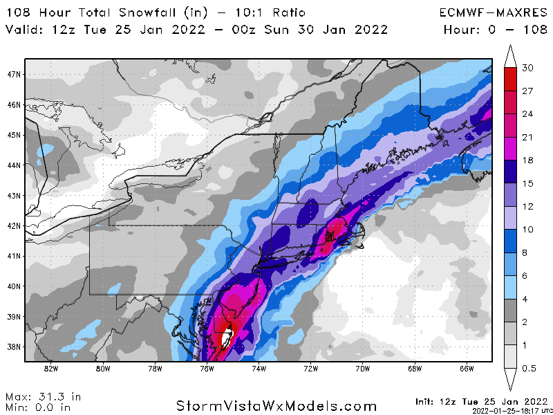
5 minutes ago, Hypothetical 240 hour snow said:
I mean central NJ, and far SE PA/northern Delaware busted, but almost everywhere else in Mount Holly's CWA did within one "snowfall category" of their expected value or overperformed slightly (and there will likely be another 2-4 inches on the backside before it is all said and done tomorrow. I can see the frustration, but in terms of busts from an area-wide standpoint this is relatively low, and has to do with mesoscale factors you just aren't going to get right in a situation that relies on a deformation band.
I am in no way faulting forecasters at all here. I think what they put out was reasonable given the almost unanimous agreement amongst the models. My saying it was a bust is just stating a fact for my area. We all know at this point we are not squeaking out much more than an inch for the remainder. Looking at current radar tells me all I need to know at this point. I can’t believe the amount of dryness out there.
-
Massive massive bust to the SE part of forum. Should have known better with Miller B but I mean every single model was showing it. Need to factor in experience more. Know better.
This time last night my area was upgraded to 10-15” along with lower Chester and Delco. Maybe 4-5” total to show for it.
-
1
-
1
-
-
56 minutes ago, JSharp said:
Where in Northern DE do you live? I live one mile south of Route 1, in Chadds Ford Township, Delaware County (one mile south of the Chadds Ford Township Bldg.)
I live 1 mile south of the PA line off of Foulk Road. I am probably 5 miles southeast of you
-
5 minutes ago, Animal said:
Yea.. I am 1/2 mile crows fly from Delaware or so.. let’s grab the alter and talk!!
Ha yes I am about a mile south of the PA border so I relate more to Delco weather and PHL vs ILG. We always flirt with disaster in these types of storms. We are probably closing in on 5” or so which is disappointing. But maybe we cash in here on some more tonight.
-
1
-
-
Snow growth slowly improving finally here in northern DE. Would be nice to squeeze out like 3-4” more
-
Radar looks strange overtop of DE. Almost like the low is in the DE bay
-
Moderate snow now. Like a switch flipped. I did read in the MA forum that the 700 low finally popped off the DE coast at 1:00. I am guessing the events were not coincidental.
-
1
-
-
Sleet sucks
-
3
-
1
-
-
Just now, Ralph Wiggum said:
Radar returns confirm that map. See my post in the obs thread with this map:

I saw your post. I approve and hope you are right. For my neck of the woods it all boils down to thermals and 850 temps. It’s either a sleet fest or a snow beat down. That will be a nowcast test unfortunately. We certainly will get the moisture it seems.
-
Just now, Ralph Wiggum said:

That is a thing of beauty. That model has been very consistent at least. I really hope it’s right on thermals.
-
Northern DE is presently seeing a mix of everything. FZRA, sleet and some fine snow. Need that coastal to ramp up and get the southern component of the winds out of the mix. One thing I can say is the winds are legit. Very gusty.
-
I think my location is going to underperform what is being shown. I think at best we see a lot of sleet. Just 15 miles too south. I hope I am wrong.
-
1
-


December 2022 Medium-Long Range Disco
in Mid Atlantic
Posted
For entertainment purposes only. Need this to shift north 50 miles.