

NEG NAO
-
Posts
6,930 -
Joined
-
Last visited
Content Type
Profiles
Blogs
Forums
American Weather
Media Demo
Store
Gallery
Posts posted by NEG NAO
-
-
On 3/29/2024 at 1:01 PM, Typhoon Tip said:
Brooklyn' or Drag perhaps consider a thread for this for early awareness.
pushing -3 ( perhaps - 4! ) SD anomaly ... trending under Long Island in recent guidance; this is historic/inference quite significant, and here there is enough cold.
Primarily this is an interior CT and points NE emerging threat, but the wholesale manifold of synoptic metrics are not excluding this reaching back SW as a major blue snow player, either.
Super synoptic considerations have shown remarkable continuity ( -NAO over the western limb) with apparent highly coupled trough. These REX couplets tend to operate within themselves and often disconnected from the telecon tapestry of the surrounding hemisphere where they set up this coherently.
still don't see a thread for this...IMO north of I-80 good chance of a few inches - the coast needs additional model support for the CMC
-
 2
2
-
 3
3
-
-
-
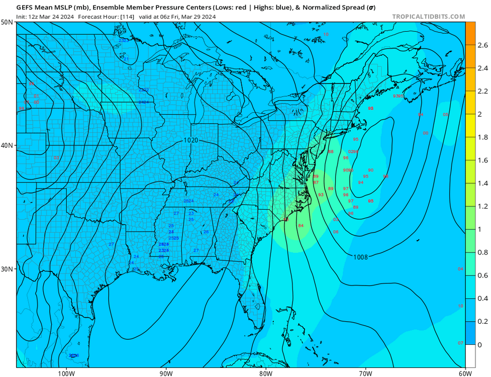
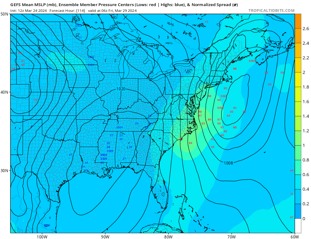
CMC once again at 0Z shows potential for accumulating snow.....IMO north of I-80 at least a few inches - TIP suggested a thread be created for this event a couple days ago saying it could extend south and west of southern New England


-
 2
2
-
4
-
-
5 minutes ago, winterwx21 said:
I think even most snow lovers in this area don't want to get lucky this time of year. Snow in April would be pretty bad since the growing season has started. Thankfully the CMC is very likely to be wrong with the snow solution for our area. Hopefully CMC is also overdoing it with the really big 3 inch plus rain amounts. Euro gives us half that amount of rain, but even if that's correct it's gonna be a miserable few days.
the 12Z Euro shifted south with the snow accumulations in the metro

-
2
-
-
18 minutes ago, SnoSki14 said:
Gfs trended in that direction with a more strung out system initially.
I don't think you can discount it completely
I still think areas north of I-80 have not seen the last of accumulating snow - and the coast is still in question - remember I like my weenies with mustard........
-
1
-
2
-
-
CMC is on a roll........a real GEM....

-
1
-
1
-
1
-
-

-
3
-
3
-
-
Just now, bluewave said:
Not close since that had a 100 year Arctic outbreak in April which was the last time NYC set 3 consecutive low temperatures.
no similarities ? is a 100 year Arctic outbreak needed this time around ?
-
1
-
-
4 hours ago, Typhoon Tip said:
Brooklyn' or Drag perhaps consider a thread for this for early awareness.
pushing -3 ( perhaps - 4! ) SD anomaly ... trending under Long Island in recent guidance; this is historic/inference quite significant, and here there is enough cold.
Primarily this is an interior CT and points NE emerging threat, but the wholesale manifold of synoptic metrics are not excluding this reaching back SW as a major blue snow player, either.
Super synoptic considerations have shown remarkable continuity ( -NAO over the western limb) with apparent highly coupled trough. These REX couplets tend to operate within themselves and often disconnected from the telecon tapestry of the surrounding hemisphere where they set up this coherently.
how does this setup compare to April 6, 1982 ? - similarities and or differences ......
-
1
-
1
-
-
Just now, JetsPens87 said:
Mustard ketchup relish and cheese for me
how about covered in snow ?
-
1
-
-
3 minutes ago, MJO812 said:
I don't get why people are giving you weenies . There is cold air around on all the models. It's a possibility if we get a phase.
I like mine with mustard on it........
-
3
-
3
-
-
18 minutes ago, bluewave said:
It will be interesting to track the evolving storm details for later in the week. It looks like there will be a powerful phase involved. So the timing will be important as to how much heavy rains the region can get. It is also forecast to generate an impressive wave break which could set up a strong Greenland block into early April. That would mean a continued stormy pattern and probably limit the number of 70° days until the blocking relaxes a bit.


and then you have the Canadian solution possibility later in the week with enough cold air dragged into the system to change it to snow

-
2
-
-
12Z regular Euro looks like the previous AI Euro for early april

-
1
-
2
-
-
44 minutes ago, MJO812 said:
Gefs is more amplified. Looks like another rainstorm possible Friday.
12Z EURO disagrees
cold air kicks it east

-
2
-
-
Just now, MJO812 said:
I think everyone checked out or doesn't realize that it still can snow into April although things need to be perfect.
some have never actually experienced getting caught with their pants down - in fact a couple well known METS did on April 6, 1982
-
1
-
2
-
-
21 minutes ago, MJO812 said:
It certainly can snow with the right pattern but it's not that common late in the month.
and the right pattern is coming up Later this week into the first few days of April with a neg NAO MJO into 8 and a coastal storm later in the week and a tight gradient storm between cold enough air and warm air to the south storm moving west to east just south of us and we are in the cold sector

-
1
-
2
-
-
look what the 12Z Canadian cooked up

-
2
-
3
-
3
-
-
11 minutes ago, JetsPens87 said:
I meant the Euro has been all fantasy.
But in any event, I also believe any snow at this point along 95 should be regarded with high skepticism.
they were saying the same thing on March 24, 1982....
-
2
-
2
-
-
Just now, MJO812 said:
With a negative NAO and MJO in 8 interiors areas have a chance.
actually its not impossible to have a surprise here if the timing is right.........
-
2
-
3
-
-
5 minutes ago, JetsPens87 said:
I haven't seen the Euro AIFS be remotely correct yet. It's all fantasy.
if it continues too perform that way they have to try and fix it..........
-
1
-
1
-
-
look what the Euro -AIFS cooked up for early next week


-
1
-
3
-
-
45 minutes ago, donsutherland1 said:
Cooler air will push into the region. One shot will begin to arrive tonight. Another somewhat stronger shot will arrive Wednesday or Wednesday night. The low temperature could approach or reach freezing on Thursday morning or Friday morning in New York City.
Milder air will begin to return during the weekend. The closing days of March could turn warm.
No significant snowfall appears likely in the northern Middle Atlantic region through at least March 20th. The probability of an unprecedented second consecutive winter with less than 10" seasonal snowfall in New York City's Central Park has continued to increase. It is now very likely that New York City will finish the 2023-2024 snow season with less than 10" of seasonal snowfall. Records go back to 1869.
The ENSO Region 1+2 anomaly was +1.0°C and the Region 3.4 anomaly was +1.4°C for the week centered around March 6. For the past six weeks, the ENSO Region 1+2 anomaly has averaged +0.98°C and the ENSO Region 3.4 anomaly has averaged +1.53°C. A basinwide El Niño event is ongoing. The ongoing El Niño event will continue to fade during March. Neutral conditions could develop during the spring.
The SOI was -3.88 on March 16.
The preliminary Arctic Oscillation (AO) was -1.234 today.
Based on sensitivity analysis applied to the latest guidance, there is an implied 99% probability that New York City will have a warmer than normal March (1991-2020 normal). March will likely finish with a mean temperature near 47.9° (5.2° above normal).
Don - I like that you are being careful with not ruling out any significant snowfall past March 20th .......
-
2
-
 1
1
-
7
-
-
2 minutes ago, psv88 said:
LOL at people acting like we are getting a snowstorm this week. Normal march temps incoming. Our last freeze usually is early April
areas north of I-80 have a good chance of some the next few weeks....
-
1
-
2
-
2
-
-
19 minutes ago, jm1220 said:
It’ll hold the bugs off for a while which is always good.
the bugs were floating around in my back yard last week already......
-
 1
1
-


April 2024
in New York City Metro
Posted
it wasn't obvious but shows it has been showing this for several days now.........and a real Meteorologist Typhoon Tip likes how the model is handling this setup.....