
vman722
-
Posts
70 -
Joined
-
Last visited
Content Type
Profiles
Blogs
Forums
American Weather
Media Demo
Store
Gallery
Posts posted by vman722
-
-
So many supercells out there right now showing rotation, especially in MO. A lot with adequate spacing as well to stay discreet. Guna be a long night.
-
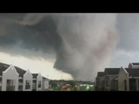
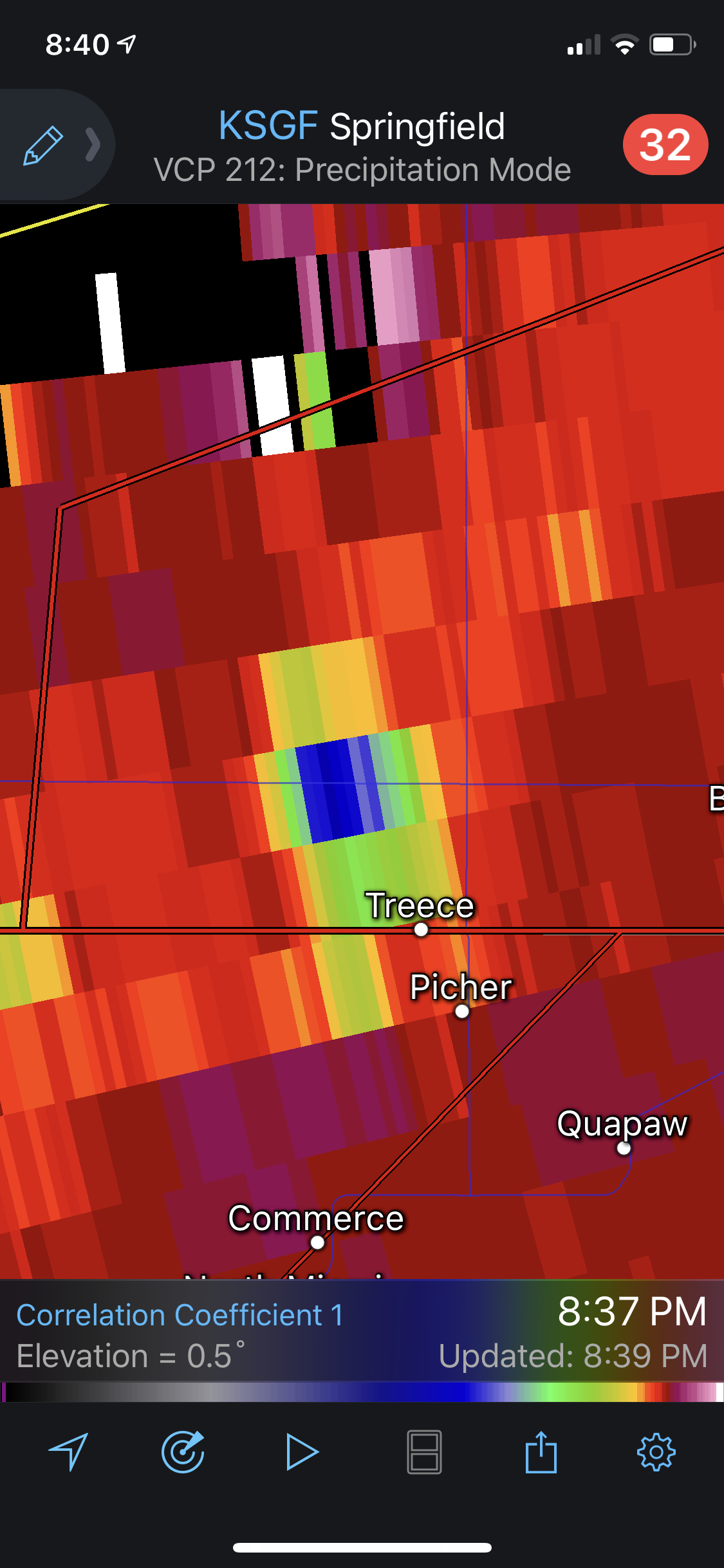
Likely rain wrapped large tornado just west of Picher. Very strong couplet and pronounced CC drop as well. Thankfully should stay well north of Joplin. Very dangerous storm.

-
1 minute ago, Natester said:
Did the HRRR ever pick up initiation in south central Oklahoma?
18z definitely did, almost nailed the initiation locations to a tee albeit slightly off on the timing. 19z run has a monster right on top of OKC around 4pm CST. This is getting very concerning very quickly considering the environment upstream with time as Quincy pointed out.
-
https://twitter.com/i/web/status/1130856609847005184
Some good reading if you're interested in some theory/explanation of the failure modes that led to a lack of a historic outbreak yesterday. Edwards is one of the forecasters that did the 13z outlook so definitely some valuable insight.
Found this through a page on the Target Area of Storm Track if anyone is interested in exploring the topic further. Some very interesting points from Jeff Duda discussing the event, one thing that stuck out to me was his discussion of the very deep nearly saturated inflow layer and its impacts along with general severe weather enthusiasts (such as myself) over reliance on the HRRR and the importance of utilizing various tools and different CAM's. Defintiely a thread worth a read.
https://stormtrack.org/community/threads/2019-05-20-event-tx-ok-ks.30833/page-2
-
 4
4
-
-
Parent circulation on the KFOR live stream is absolutely massive. Back on the ground now.
-
https://www.severestudios.com/storm-chasers/tornado.tech.html
Some classic structure able to be seen right now on the tornado tech stream. Looks like a rotating wall cloud developing quickly.
-
1
-
-
Southern most cell is a beast.
-
Dryline really starting to light up now. Lapse rates are no joke today, these are going severe very quicky.
-
Edmonson cell pushing out a hook and should get a warning here shortly as well. Looks like things are heating up.
-
80/70 probs on the tornado watch for the panhandle, higher than I was expecting forsure.
-
2
-
-
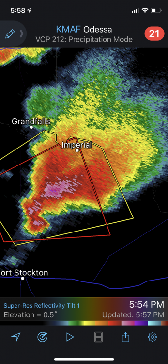
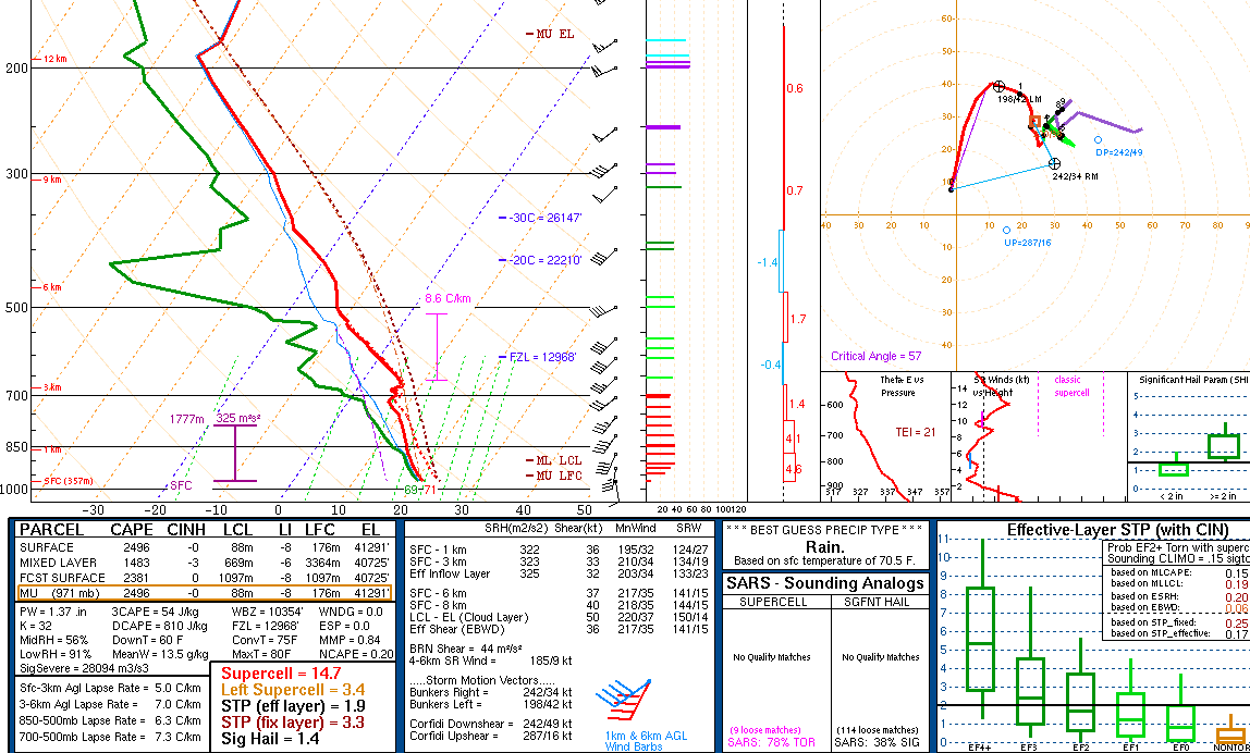
Most recent sounding from OUN. Pretty impressive already.

-
Wow is all I can say pulling these soundings on the latest HRRR around 19z. Really hope those discreet cells grow upscale quickly...
-
2 hours ago, ryan1234 said:
This weekend looks interesting (if you're into severe weather). The forecast discussion from GSP is worth a read as well. Looks like the majority of us will have something to track, especially by Sunday.
Agreed. Also think the sometime around the 18th does as well. Euro and GFS both have a very nice looking troughs with deep surface lows coming into a similar location as the one this weekend. Two active looking periods to watch no doubt. Interested to see if the gulf can recover in time after the first system. Like the look of the 850's for both systems. AL/MS def should be watching those.
-
1
-
-
18 hours ago, Nick Esasky said:
Sorry for another intrusion from a SE forum member.
Going to Grand Targhee next week and want to know if there's a place the group here would recommend looking for the best forecast for the mountain itself. As one would expect, I'm seeing wildly different forecasts for Mon-Thurs of next week. I expect conditions to be great, but just curious that their website is showing 46/29 for Monday 4/1 while their app shows 34/29 and snow. Could be as simple as one is for the base and one for the summit, but hoping someone here has figured that out for this resort before. Thanks.
https://opensnow.com/dailysnow/grandtarghee
https://opensnow.com/location/grandtarghee
These should help you out.
-
Last winter was too good to us in the ATL and surrounding burbs, knew we were bound for an inevitable disappointment this go around. Temps aren't even close right now and looking at mesoanalysis, they are marginal even way behind the front back in AL. Hopefully we get a shot in February sometime but not holding my breath.
-
Another ATLien here. Just got back from Colorado where I got to ride the deepest and lightest snow I've ever experienced. It's only fitting that I come back to a dusting fiasco in the A. Regardless of what falls, looking like a hard freeze is on the way tomorrow night. Hopefully, the wind will work its magic and keep the ice to a minimum. But like others have said, working from home is fine with me too. Lucky to be able to.

Mid to Late May 2019 Severe Threats
in Central/Western States
Posted
Supercell south of Chapman KS could be the next one to go...