vman722
-
Posts
82 -
Joined
-
Last visited
Content Type
Profiles
Blogs
Forums
American Weather
Media Demo
Store
Gallery
Everything posted by vman722
-
-
Think it will be a pretty different situation come daylight unfortunately.
-
If this manages to cycle once again I’ll be blown away.
-
Couplet is still pretty tight.
-
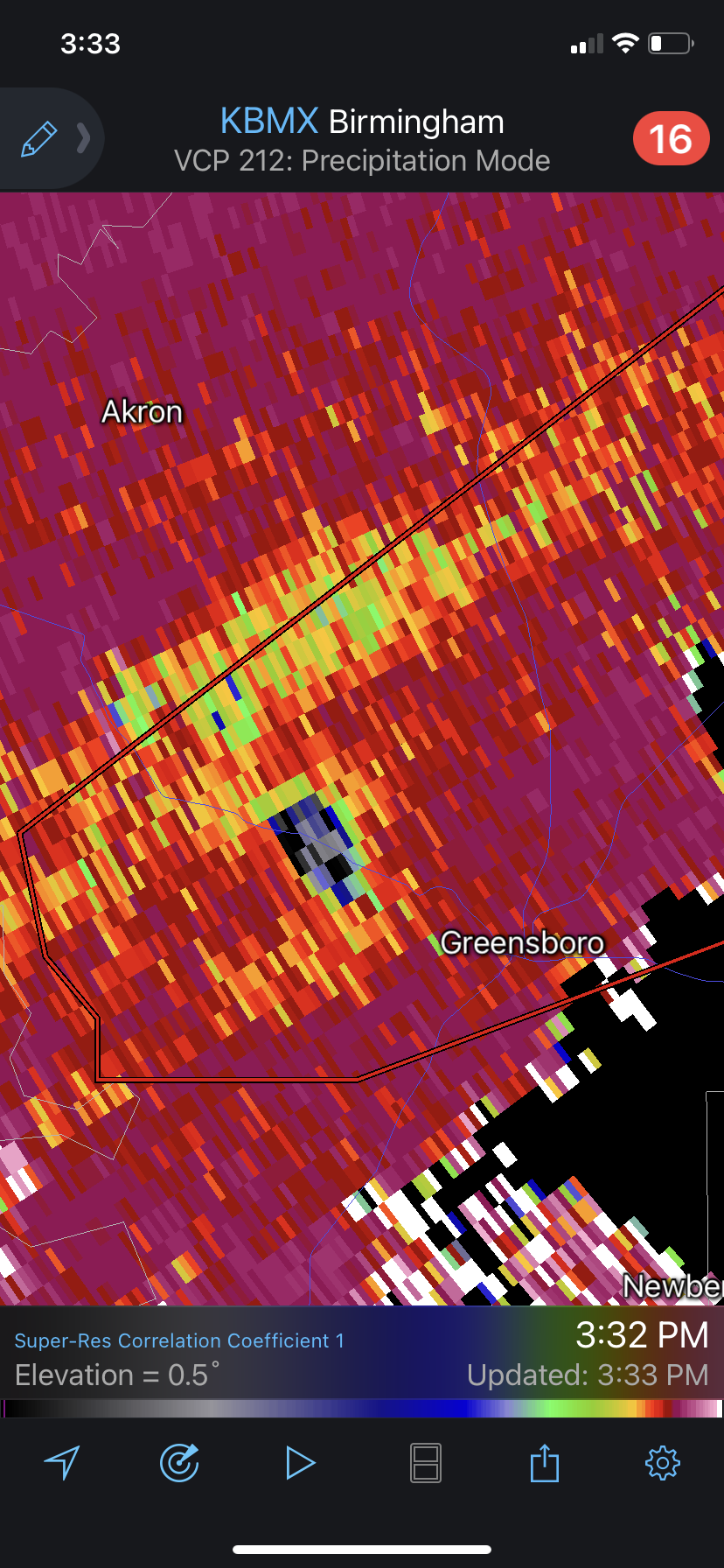
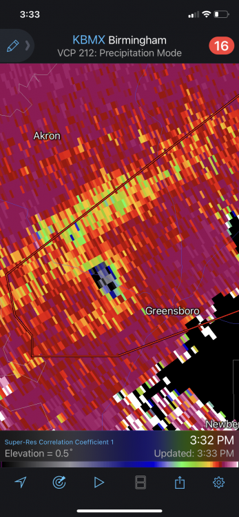
Debris sig on CC is 2 miles wide.
-
CC just dropped some more... man.
-
Oh yeah that hook is definitely coming back around. Very similar to its previous cycle.
-
About a half hour ago it fully cycled and wasn’t even severe warned, only to rapidly intensify and drop a monster. Let’s see if it can do it once more.
-
Looks heavily rain wrapped at the moment.
-
The little kidney bean near Shannon MS has exploded from nothing the last few scans.
-
Agreed. Currently working with extreme effective shear on the order of 80+ kts. Will only move into better SRH with time.
-
Humphress has a wedge on his stream.
-
Think I saw that too. Looked like the Hackleburg storm in terms of just being so massively wide. If that whole thing was indeed the wedge.
-
That seemed to be what held back the NE MS cells earlier but sure isn't the case with these AL monsters. These are beyond impressive. Effective shear for both cells per mesoanalysis up to 70-73kt.
-
Incredible debris ball. So scary
-
This seems to be the biggest issue, effective SRH and SRH in general is displaced much more east than expected so far.
-
Still forecast to deepen the next few hours...
-
Did Reed stop streaming?
-
Good spacing N of Columbus in MS though, Calhoun city cell could be a problem shortly. Definitely looks messy further south.
-
Once again, this system is exponentially more dynamic than last weeks. And last week did end up verifying in the high risk area. There is plenty of clearing in the main expected initiation zone. Already extreme amounts of low level instability. I hope this busts as much as the next guy but these concerns are being tossed because of the real time observational data.
-
I’m thinking a storm reports map similar to 4/28/14 with maybe a little more action into TN. Overall pretty aligned with your thinking. Praying for as little loss of life and property as possible.
-
Lol one slightly more tame run of the HRRR and the event ceiling gets mostly discounted immediately. Careful with that one folks. This still looks rock solid synoptically. As always, setup of the outflow boundaries and mesoscale details day of will determine magnitude, but this and last weeks setup are not the same.
-
Parents have a house up there on the north end of Lake Lanier in Gainesville. May have to make the trip up tonight. Models last night had me interested, seems like it's game on. Not expecting a whole lot but could be some real pretty scenery.
-
Agreed. Also think the sometime around the 18th does as well. Euro and GFS both have a very nice looking troughs with deep surface lows coming into a similar location as the one this weekend. Two active looking periods to watch no doubt. Interested to see if the gulf can recover in time after the first system. Like the look of the 850's for both systems. AL/MS def should be watching those.