

Grayman
-
Posts
501 -
Joined
-
Last visited
About Grayman

-
Probably should be in banter bit can I put out pre emergent if I overseeded with winter rye. Warm season grass is Bermuda. Thought I read it would stunt the rye. Huge issue last year with grabgrass
-
How about the no charge call? I’m not a fan of either but refs let a lot go.
-
This cracked me up. Sometimes we all feel that way.
-
The “I bring the mojo” Jan 30-Feb 1 potential winter storm
Grayman replied to lilj4425's topic in Southeastern States
You might end up with 8 inches if radar returns are correct -
The “I bring the mojo” Jan 30-Feb 1 potential winter storm
Grayman replied to lilj4425's topic in Southeastern States
Can somebody point out where ULL is located right now? -
The “I bring the mojo” Jan 30-Feb 1 potential winter storm
Grayman replied to lilj4425's topic in Southeastern States
That’s only a good thing in this situation lol -
January 30th- Feb 1st ULL and coastal storm obs
Grayman replied to JoshM's topic in Southeastern States
Light snow in Rockingham. Slowly picking up -
The “I bring the mojo” Jan 30-Feb 1 potential winter storm
Grayman replied to lilj4425's topic in Southeastern States
-
The “I bring the mojo” Jan 30-Feb 1 potential winter storm
Grayman replied to lilj4425's topic in Southeastern States
-
January 30th- Feb 1st ULL and coastal storm obs
Grayman replied to JoshM's topic in Southeastern States
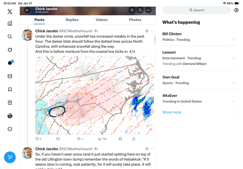
I’m no pro. But Eric Webber pointed out that it’s some kind of warm font that can really create a huge axis of snow. He made a post on ex about it, but I don’t know how to link it. -
January 30th- Feb 1st ULL and coastal storm obs
Grayman replied to JoshM's topic in Southeastern States
Is anyone surprised by the radar returns that are lightened up south and west of NC? -
The “I bring the mojo” Jan 30-Feb 1 potential winter storm
Grayman replied to lilj4425's topic in Southeastern States
Currently, it looks like it’s off the coast of Charleston to me? Most of us east of 95 needed it closer to the coast, correct? -
The “I bring the mojo” Jan 30-Feb 1 potential winter storm
Grayman replied to lilj4425's topic in Southeastern States
Like I said, I’m an amateur and I’m not sure how to look at that based on that link he posted. Feel like putting me through school real quick. I assume that’s bad news. -
The “I bring the mojo” Jan 30-Feb 1 potential winter storm
Grayman replied to lilj4425's topic in Southeastern States
I found this interesting. I’m an amateur. Do you have any updates on where you think it might be forming -
The “I bring the mojo” Jan 30-Feb 1 potential winter storm
Grayman replied to lilj4425's topic in Southeastern States
Does anybody have any good tools to try to see where the low pressure is trying to set up off the coast? I’m talking about something live or updates every hour. I’ve been tracking this for a week so I figure I’d need something to do tonight besides looking at the radar.


