

Tucker1027
-
Posts
330 -
Joined
-
Last visited
Content Type
Profiles
Blogs
Forums
American Weather
Media Demo
Store
Gallery
Everything posted by Tucker1027
-
00z tonight per someone over at Southernwx
-
Thank you for this!
-
I just wentt back and looked at the forum for the storm last January and wish I didn't... it ends with "Looks like the dry Euro runs are going to verify here. Ironically it got onboard with 4+ inches here at the last minute. I'll be shocked if I get over 2". The American models, barring a huge surprise, are going to be miserable failures."
-
This is a model war….. and the loser might not recover. .
-
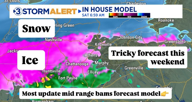
Updated from Channel 3 .
-
Local 3 in Chattanooga BAMS
-
I have no clue if this means anything, but went back and looked at this first system that is coming through today at about 3 days out…. Icon handled it the best. .
-
Big takeaway is NWS is leaning on euro not handling shallow cold air well at all especially in the valley .
-
Our in house met… says he thinks temps on euro are 3-4 degrees too warm.. Also, talking about cold air getting trapped by mountains .
-
NWS Cont. Too far out to know exactly how it’s going to handled the Arctic Cold
-
2 pm briefing Heaviest Snow North of Knoxville Heaviest Ice in south portions of area 60% to 80% chance of at least 1 inch of meltwater Onset by 7 am on Saturday (medium confidence) Thinking it will start as snow then warm nose will show up Probability of 3 inches of snow Chattanooga - 10% Knoxville -55% Tri-Cities - 70% Over 8 inches Knoxville -15% Tri-Citis - 25% Probability of Freezing Rain >.25 Chattanooga - 60% Knoxville -25% Tri-cities - 15% Probability of Freezing Rain >.50 Chattanooga 20% .
-
Chattanooga will be tracking flooding .
-
EURO looks like a whole county south out west.
-
WINTER STORM WATCH IN EFFECT FROM LATE FRIDAY NIGHT THROUGH SUNDAY EVENING... * WHAT...Heavy mixed precipitation possible. Total snow accumulations between 4 and 10 inches will be possible, primarily north of Knoxville with the heaviest accumulations near the Kentucky border and far western Virginia. In addition to the snow, ice accumulations up to one half of an inch will be possible, primarily south of Knoxville. The greatest ice accumulations will likely be south of a line from Crossville to Tellico Plains, especially the southern Cumberland Plateau. * WHERE...Portions of southwest North Carolina, east Tennessee, and southwest Virginia. * WHEN...From late Friday night through Sunday evening. * IMPACTS...Expect power outages and tree damage due to the ice. Travel could be impossible. * ADDITIONAL DETAILS...This is a complicated forecast and details regarding the location of heaviest snowfall and freezing rain totals remain uncertain. Significant changes could occur in the coming days so please continue to monitor future forecasts. PRECAUTIONARY/PREPAREDNESS ACTIONS... Monitor the latest forecasts for updates on this situation. .
-
North Georgia Winter Storm Watch: WINTER STORM WATCH IN EFFECT FROM LATE FRIDAY NIGHT THROUGH MONDAY MORNING... * WHAT...Heavy mixed precipitation possible. Total snow and sleet accumulations up to 4 inches and ice accumulations greater than one quarter inch possible. * WHERE...Portions of north central, northeast, and northwest Georgia. * WHEN...From late Friday night through Monday morning. * IMPACTS...Expect power outages and tree damage due to the ice. Travel could be impossible. The hazardous conditions could impact the Monday morning commute. PRECAUTIONARY/PREPAREDNESS ACTIONS... Monitor the latest forecasts for updates on this situation. Persons should consider delaying all travelSaturday and Sunday. If travel is absolutely necessary, drive with extreme caution. Consider taking a winter storm kit along with you, including such items as booster cables, flashlight, shovel, blankets and extra clothing. Also take water, a first aid kit, and anything else that would help you survive in case you become stranded. .
-
I will report back...
-
Have a NWS briefing for work at 2pm... going to be interesting. Ukie dropping 3 inches of precipitation is crazy.
-
Is the GFS the two wave solution some were talking about? .
-
GFS is more stubborn than my wife…. Must be why I like it. (Sorry for the banter) .
-
Honestly have no idea what to prepare for… Ice or a muddy back yard… .
-
The HP coming back is good for us correct? .
-
glad we trended colder by a tick on the 6z euro... maybe the bleeding will stop and it will trend back to us.
-
Chattanooga MET this morning saying they buy the northern trend, but don’t buy the temp profiles on the euro yet. .
-
.
-
January 25-26 Winter Storm Potential
Tucker1027 replied to Ralph Wiggum's topic in Philadelphia Region
.


