
CNY-WXFREAK
-
Posts
3,872 -
Joined
-
Last visited
Content Type
Profiles
Blogs
Forums
American Weather
Media Demo
Store
Gallery
Everything posted by CNY-WXFREAK
-
Upstate/Eastern New York
CNY-WXFREAK replied to BuffaloWeather's topic in Upstate New York/Pennsylvania
Now we begin the year without a Spring, right into Summer Mid-May! -
Upstate/Eastern New York
CNY-WXFREAK replied to BuffaloWeather's topic in Upstate New York/Pennsylvania
I got pounded, close to 8" new, and did not expect it at all! -
Upstate/Eastern New York
CNY-WXFREAK replied to BuffaloWeather's topic in Upstate New York/Pennsylvania
City of Syracuse is getting absolutely crushed right now,WoW! If this band settles over the area some places should have no problem seeing 8-10 quick inches! -
Upstate/Eastern New York
CNY-WXFREAK replied to BuffaloWeather's topic in Upstate New York/Pennsylvania
What else is new this year. What a horrific yr for LE here in So. Oswego cty. -
Upstate/Eastern New York
CNY-WXFREAK replied to BuffaloWeather's topic in Upstate New York/Pennsylvania
After this brief squall, look for a band to set-up, just to the South of here, probably right along the Thruway it looks like. -
Upstate/Eastern New York
CNY-WXFREAK replied to BuffaloWeather's topic in Upstate New York/Pennsylvania
Vicious squall rolling through right now. 0 vis as I can not see the house 50yds from me! Very wet snow, almost synoptic like with temps in the low 30's. -
Upstate/Eastern New York
CNY-WXFREAK replied to BuffaloWeather's topic in Upstate New York/Pennsylvania
Squall parameter looks fantastic. Someone should get pounded somewhere, lol, but no here. -
Upstate/Eastern New York
CNY-WXFREAK replied to BuffaloWeather's topic in Upstate New York/Pennsylvania
I could walk to the center of this tiny , but intense, band thats just to my north with some embedded yellow returns coming from the center so I'd imagine 2-3"/hr and I'm missing it by !/3 of a mile. -
Upstate/Eastern New York
CNY-WXFREAK replied to BuffaloWeather's topic in Upstate New York/Pennsylvania
I see more of a spray with perhaps a few embedded streamers, but not like its showing, but what do I know? -
Upstate/Eastern New York
CNY-WXFREAK replied to BuffaloWeather's topic in Upstate New York/Pennsylvania
Snowing nicely across Wayne County at least from a Vid-cam pov. -
Upstate/Eastern New York
CNY-WXFREAK replied to BuffaloWeather's topic in Upstate New York/Pennsylvania
Dryslot is gonna shut everything off across all of SNE, lol, WOW I'd be extremely bummed if that occurred. -
Upstate/Eastern New York
CNY-WXFREAK replied to BuffaloWeather's topic in Upstate New York/Pennsylvania
We will get more from the wrap around than NYC did the main event, lol, and they we're in the Jackpot zone on most guidance. -
Upstate/Eastern New York
CNY-WXFREAK replied to BuffaloWeather's topic in Upstate New York/Pennsylvania
The busts with this dud will be immense, lol! -
Upstate/Eastern New York
CNY-WXFREAK replied to BuffaloWeather's topic in Upstate New York/Pennsylvania
Looks like Manhattan is seeing some S+ at the moment and my brother called and said their expecting 2-3"/hr rates this afternoon into early evening. Very heavy precip in So. NJ with sleet in between. I wonder how many stories up the asos set-up is at. -
Upstate/Eastern New York
CNY-WXFREAK replied to BuffaloWeather's topic in Upstate New York/Pennsylvania
Look at how far East the RGEM is compared to other guidance, WOW. This should be the biggest bust of em all, lol! Has the Poconos getting .46"/liq equ, lol! -
Upstate/Eastern New York
CNY-WXFREAK replied to BuffaloWeather's topic in Upstate New York/Pennsylvania
Sn to at times S+ but mostly Sn right now and the flake size has indeed increased to a nice accumulating snow, if it can drop below that magical number of 32F, then we could get something going but if not we have to wait till at least this evening! -
Upstate/Eastern New York
CNY-WXFREAK replied to BuffaloWeather's topic in Upstate New York/Pennsylvania
Mesoscale Discussion 0110 NWS Storm Prediction Center Norman OK 0747 AM CST Wed Mar 07 2018 Areas affected...eastern PA...central and northern NJ Concerning...Heavy snow Valid 071347Z - 071745Z SUMMARY...Heavy hourly snowfall rates of 1-2 inches per hour are likely to develop later this morning. Locally higher rates (2+ inches/hour) are possible primarily after noon local time within the frontal snow band and/or convectively augmented bursts. DISCUSSION...13Z surface analysis places a sub 1000mb developing low 60 mi ESE of WAL. Temperatures are in the 32-34 degrees F range from the northern part of Chesapeake Bay to NYC. The 12Z IAD RAOB from Dulles, VA showed a temperature profile subfreezing except immediately near the surface. The 500mb temperature was -25.5 C. Looping water-vapor imagery indicates the mid-level trough was located over the central Appalachians as of 13-14Z. As this disturbance approaches the region, strong mid-level ascent associated with the trough (leading to significant columnar cooling in the mid-levels) coupled with the northern periphery of a plume of steep 700-500mb lapse rates (7-8 degrees C per km) will combine and result in pockets of weak buoyancy and upright convection. Convection will increase in coverage from northern DE northeast towards the NYC area during the late morning into the early afternoon. Models indicate the development of strong frontogenetic forcing will begin primarily around or after 17Z. As the deep-layer large-scale ascent strengthens and becomes vertically juxtaposed with the intensifying frontogenesis, hourly precipitation rates will markedly increase from around 0.10 inch to 0.10-0.25 inch. Marginal surface temperatures will effectively result in a significant concern/limiting factor for the spatial coverage of 1+ inch/hour rates farther southeast across portions of NJ as a sharp rain/snow precipitation-type gradient becomes established. Eastern PA into northern NJ will likely maintain snow as the precipitation type and heavy snowfall rates will focus in a narrow corridor from the north part of PHL north-northeast into northern NJ. Higher elevations will likely attain the coldest temperatures (due to the low-level thermal profile cooling as elevation increases from sea level to 1-2 kft) and the most intense accumulation/hourly rates. Meanwhile the Nam dropped almost 3/4 of the precip over the Poconos. Just proving scientifically that the NAM clearly went to **** at 06Z and it remains there and its flat out wrong, plain and simple. -
Upstate/Eastern New York
CNY-WXFREAK replied to BuffaloWeather's topic in Upstate New York/Pennsylvania
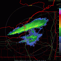
RLMFAO Where'd the snow across the Catskills go as well as the Poconos? Does anyone in here actually think the Catshills will get 8-10" and the Poconos 3-6" if that, especially with reflectivity like this. -
Upstate/Eastern New York
CNY-WXFREAK replied to BuffaloWeather's topic in Upstate New York/Pennsylvania
Its currently 32F where I am and the dp is 27F so there's more room for a slight drop in temp due to wet-bulb processes. We should end up right around 30 -31F but only if the precip gets heavy enough will the column cool enough to get down that low, but it has to at least SN cause I'm not sure we see any S+ so. -
Upstate/Eastern New York
CNY-WXFREAK replied to BuffaloWeather's topic in Upstate New York/Pennsylvania
There also looks like there's quite a few dry areas down near SE NY around rt17 Monticello area but the Catskills are going to get absolutely demolished, seriously! -
Upstate/Eastern New York
CNY-WXFREAK replied to BuffaloWeather's topic in Upstate New York/Pennsylvania
It's actually looks like it has gotten a bit heavier around here as it continues to blossom into a rather large area of precip! Temp has also wet-bulbed to 31 where I am but I suspect as returns get a bit lighter we'll go over to a rn/sn mix. I'm like what I'm seeing thats for sure. -
Upstate/Eastern New York
CNY-WXFREAK replied to BuffaloWeather's topic in Upstate New York/Pennsylvania
Of course cuz, as I used to rag on anyone who said such nonsense. If it snows hard enough and its cold enough aloft then itll snow whenever it wants to including into the Month of May as its happened only once or twice since I been up here. -
Upstate/Eastern New York
CNY-WXFREAK replied to BuffaloWeather's topic in Upstate New York/Pennsylvania
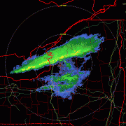
Don't know about anyone else but this looks interesting for the immediate Syracuse area and the surrounding villages. It seems to just be blossoming and forning overhead as it slowly moves to the West, where it gets to and how far West it gets is the magic Question right now. I'm thinking Wayne county somewhere but it looks like its going to be a very slow process to get there. -
Upstate/Eastern New York
CNY-WXFREAK replied to BuffaloWeather's topic in Upstate New York/Pennsylvania
Did I say something wrong? I'm serious as I thought it was this upcoming weekend or am I way off base, lol? -
Upstate/Eastern New York
CNY-WXFREAK replied to BuffaloWeather's topic in Upstate New York/Pennsylvania
IDK about anyone else but its legitimately snowing here, allbeit lightly, but its definitely snow thats falling and was not expecting anything till at least this afternoon at the earliest but surprise surprise an early arrival. Does it actually become the Western cut-off pt, as it continues to head West of here. Is it coming down by you CNY cause its definitely -SN here presently and it doesn't look like its a simple sn/sh either.

