
Wonderdog
-
Posts
3,725 -
Joined
-
Last visited
Content Type
Profiles
Blogs
Forums
American Weather
Media Demo
Store
Gallery
Posts posted by Wonderdog
-
-
4 minutes ago, rjvanals said:
Rare DCA more than IAD coastal storm?
It's not a coastal storm.
-
 1
1
-
-
Important for the EURO to improve from last night's run.
-
1
-
-
52 minutes ago, BristowWx said:
It’s either onto something or on something….see what I did there with the word play….I’m on fire today
If you have to explain it.......
-
 1
1
-
-
54 minutes ago, BristowWx said:
Well it’s better..for some.
It's better for everyone
-
7 hours ago, 87storms said:
gfs is just clearly not in the same league as the euro at 5 days out...it certainly needs the cmc or uk in its camp. would be interesting to know why the euro is so good.
What is the criteria for ranking the various models? I believe that the GFS has been advertising this particular storm for at least five days and the EURO started showing the storm yesterday. Yes, the GFS has been all over the place wrt impact on the Mid-Atlantic but it seems to be in lockstep with the EURO this morning, with the EURO catching up with the GFS. And is the EURO finished with its corrections? Still two or three model runs to go. (And the GFS has improved ever so slightly in the last 6 hours).
-
Just now, BristowWx said:
Fair enough. Even as depicted 3 inches for us would be epic.
Go for the gold. You only live once, especially in a nina.
-
 1
1
-
-
1 minute ago, BristowWx said:
Yeah not bad. Thanks. Need to move that whole thing west a bit. This will be interesting to see what actually happens. Euro should be deadly at this range. I’m not optimistic for NOVA seeing that map.
Yeah, it's going to be close. But we have plenty of time. Of course we don't want to much of an adjustment to the west, or it might be raining.
-
28 minutes ago, BristowWx said:
You know it’s gonna be painful to have warning level snows one County below us… I’m just getting you mentally ready for it
That would make a road trip a piece of cake. But I have a feeling it's time we caught a break.
-
1 hour ago, NorthArlington101 said:
That’s a pretty absurd panel, lol.

Hard to see the Eastern Shore in this pic.
-
1
-
 1
1
-
-
27 minutes ago, WxUSAF said:
12z has a better shortwave presentation than 6z, but it’s farther south. Move it north a bit and the result is more like the 0z storm.
It'll trend north.
-
Looks as if the EURO may be starting to cave to the GFS with respect to the development of a trailing LP following the front this weekend. At the very least, definitely worth tracking.
-
21 minutes ago, BristowWx said:
It’s a tick better than 12z
A tick? Looks like 3-5 to me, until the next model run.
-
Nice storm developing in the gulf in only 9 days or so.
-
1
-
-
2 hours ago, BristowWx said:
a little adjustment and it would be something…or nothing
Well put (lol). This threat keeps hanging around though. That makes it intriguing.
-
8 minutes ago, BristowWx said:
not sure. I really don't know whats a good thing anymore. Everything I thought should be good turns out not so good...its befuddling
You need to start drinking heavily!
-
18 minutes ago, BristowWx said:
indeed at least thats how it looks to me.
True but it looks like the system has slowed a bit and the ridging out west looks less flat. Maybe a good thing ?
-
41 minutes ago, WinterWxLuvr said:
Only if you like cold, dry and wind after all of the precip is gone
Ok, I guess I don't like that look then.
-
2
-
-
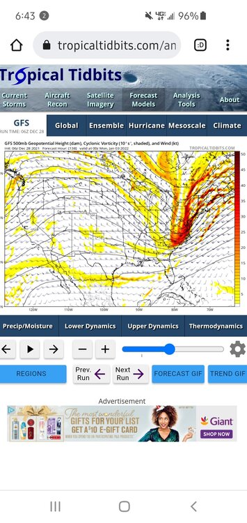
Is this the kind of look we're looking for at 500
-
45 minutes ago, nj2va said:
18z GEFS doesn’t seem supportive of the OP for the 3rd, at least looking at 500 anomalies and vort maps on TT.
The op runs at 500 have quite the spread over the past five runs for the 3rd. Very little, if any consistency. We need a couple of more days to start to get some clarity.
-
24 minutes ago, Weather Will said:
WB 6Z GEFS…at least January temps look to be in the cards next week, with some snow chances increasing


That's all we can ask for. That is quite an incursion of cold air into the U.S. in January. Since it's 10-15 days away, it's hard to trust the models based on their track record. So we wait.
-
13 minutes ago, Deer Whisperer said:
It's Christmas, relax

He is.
-
Rain and 66 on 66 in Gainesville
-
Just now, WxUSAF said:
By recent standards, quite encouraging 12z Op runs so far with at least possibilities starting after New Years.
Yes, and it shows a gulf low at hr. 384 as opposed to the 6z run which showed a clipper type system getting ready to miss us
-
Maybe one of those pesky GLL's.


January 3 CAPE Storm
in Mid Atlantic
Posted
No we probably don't want that