

Cerakoter1984
-
Posts
303 -
Joined
-
Last visited
Content Type
Profiles
Blogs
Forums
American Weather
Media Demo
Store
Gallery
Everything posted by Cerakoter1984
-
MO/KS/AR/OK 2019-2020 Winter Wonderland Discussion
Cerakoter1984 replied to JoMo's topic in Central/Western States
Lezak's pattern doesn't work in years like this one until it's already almost too late. -
MO/KS/AR/OK 2019-2020 Winter Wonderland Discussion
Cerakoter1984 replied to JoMo's topic in Central/Western States
There should be some disappearing reappearing of that system over the next few days but it looks to have a shot. -
MO/KS/AR/OK 2019-2020 Winter Wonderland Discussion
Cerakoter1984 replied to JoMo's topic in Central/Western States
Things continue head in a positive direction as far as the progression vs my analogs. Curiosity has wondering if this evolves into a 1978/2013 type of winter that lays down cold and snow then locks it in place here. I'm anxious to see what the final anomalies look like vs my maps. -
MO/KS/AR/OK 2019-2020 Winter Wonderland Discussion
Cerakoter1984 replied to JoMo's topic in Central/Western States
I don't mind it. Glad it's cooling down and it's at least some possible rainfall. -
MO/KS/AR/OK 2019-2020 Winter Wonderland Discussion
Cerakoter1984 replied to JoMo's topic in Central/Western States
Upcoming 15 days of December looking pretty radical. Regardless what modelling is currently showing, there should be a nice southern U.S. storm in there before long. Pattern looks amazing. This pattern is how you get snow AND keep it for a long time if everything works out right. -
MO/KS/AR/OK 2019-2020 Winter Wonderland Discussion
Cerakoter1984 replied to JoMo's topic in Central/Western States
I think there's a way to combine and use his technique with others to produce longer range and much more accurate mid-range weather forecasts for event timing, precip liklihood etc... Just not sure exactly what that is yet. I agree with your post about when the pattern "starts". My thought is and always has been that a new pattern started between June 25 and July 10 every year but some are just much harder to detect. Every way I tried to sort reasonable and best analogs when I was doing them a few months back still gave me the same map with the SW ridge. Pretty interesting that they arrived at the same idea. -
MO/KS/AR/OK 2019-2020 Winter Wonderland Discussion
Cerakoter1984 replied to JoMo's topic in Central/Western States
Given what I've seen the past few weeks, interesting events coming up in la la land on the models may actually have some merit to it around the 5th. Give/take a day or 2. -
MO/KS/AR/OK 2019-2020 Winter Wonderland Discussion
Cerakoter1984 replied to JoMo's topic in Central/Western States
First pattern I've seen begin to repeat or lock on Euro since mid Autumn. Hope it happens. -
MO/KS/AR/OK 2019-2020 Winter Wonderland Discussion
Cerakoter1984 replied to JoMo's topic in Central/Western States
My comment won't get close to doing it justice but just wanted to say you do great work. That stuff is awesome to me. -
MO/KS/AR/OK 2019-2020 Winter Wonderland Discussion
Cerakoter1984 replied to JoMo's topic in Central/Western States
What a GFS run that was. Lol -
MO/KS/AR/OK 2019-2020 Winter Wonderland Discussion
Cerakoter1984 replied to JoMo's topic in Central/Western States
Getting there... If the Euro is too warm and too far West with the cold here, then I think we may have a candidate for a storm of some interest.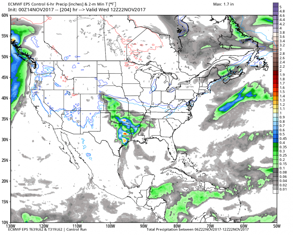
-
MO/KS/AR/OK 2019-2020 Winter Wonderland Discussion
Cerakoter1984 replied to JoMo's topic in Central/Western States
I fully expect to see an interesting storm in our area near Thanksgiving. -
MO/KS/AR/OK 2019-2020 Winter Wonderland Discussion
Cerakoter1984 replied to JoMo's topic in Central/Western States
Yes. Going to be hard to see a late fall pattern better than that. When retrogression begins,.... boom. This winter could be pretty historic. Too many dominoes falling in a row for it not to. Looking forward to writing about a lot of exciting weather this winter. Really haven't had much weather to write about around here in nearly 3 years. -
MO/KS/AR/OK 2019-2020 Winter Wonderland Discussion
Cerakoter1984 replied to JoMo's topic in Central/Western States
We're heading into a pretty good spot for being November. Hoping for a bit of retrogression after this pattern sets up. -
MO/KS/AR/OK 2019-2020 Winter Wonderland Discussion
Cerakoter1984 replied to JoMo's topic in Central/Western States
N. Pac configuration and solar mostly. It was a strong La Nina but it fits an overall pattern of years similar to 2010-11, 1988-89 also. There's some huge potential for major pattern amplification and blocking once we get a little way into winter and all throughout the rest of it. That also shares the characteristics of 1917-18. -
MO/KS/AR/OK 2019-2020 Winter Wonderland Discussion
Cerakoter1984 replied to JoMo's topic in Central/Western States
I believe this year will be 100% different than the last 2. I think that we are in for a pretty wild winter around these parts. -
MO/KS/AR/OK 2019-2020 Winter Wonderland Discussion
Cerakoter1984 replied to JoMo's topic in Central/Western States
It makes me really happy but also disappointed. 200% more than last year is still below normal. Lol -
MO/KS/AR/OK 2019-2020 Winter Wonderland Discussion
Cerakoter1984 replied to JoMo's topic in Central/Western States
Gonna throw this map up. I'm still leaning pretty hard towards this.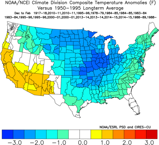
-
MO/KS/AR/OK 2019-2020 Winter Wonderland Discussion
Cerakoter1984 replied to JoMo's topic in Central/Western States
November looks seriously a lot like early winter from where I'm sitting. -
MO/KS/AR/OK 2019-2020 Winter Wonderland Discussion
Cerakoter1984 replied to JoMo's topic in Central/Western States
Looks like I would have gotten snow in about two of those really. Talk about winters of being one county away from the fun. Yikes! -
MO/KS/AR/OK 2019-2020 Winter Wonderland Discussion
Cerakoter1984 replied to JoMo's topic in Central/Western States
Things looking to take off pretty fast over the next few days. Very reminiscent of 2000 and 2013 in my opinion. -
MO/KS/AR/OK 2019-2020 Winter Wonderland Discussion
Cerakoter1984 replied to JoMo's topic in Central/Western States
I'm looking forward to it. I'm still working and waiting on a few things to happen also before I write my thoughts out. Things are looking good for my area, in my opinion. The next 2 weeks are very critical in the overall long term pattern. Trades burst looks to cool ENSO back down. Something to keep in mind also, +AAM, -QBO, and a climbing PDO all argue for a -AO and a period of at least some cold for a large portion of the US this winter. -
MO/KS/AR/OK 2019-2020 Winter Wonderland Discussion
Cerakoter1984 replied to JoMo's topic in Central/Western States
I'm going with a slightly harsher scenario (cold) than most. I like 2000-01, 1984-85, 2008-09, and 2010-11. Going to get into research pretty quick and see if i can make an analog map or 2. -
Arctic Sea Ice Extent, Area, and Volume
Cerakoter1984 replied to ORH_wxman's topic in Climate Change
Thank you. -
Arctic Sea Ice Extent, Area, and Volume
Cerakoter1984 replied to ORH_wxman's topic in Climate Change
Where can I find that chart? That's a neat way to look at the temperatures.

