

Cerakoter1984
-
Posts
303 -
Joined
-
Last visited
About Cerakoter1984

-
Simply amazing stuff.
-
MO/KS/AR/OK 2020-2021 "Winter" Discussion
Cerakoter1984 replied to JoMo's topic in Central/Western States
SST profiling and persistence would say that I'd bet on more than a week of what we all had down here last season. Niña signature isn't necessarily the attention getter here, in my opinion, as much as the hard contrast off Baja and the strengthening warm mode in the N. Pac. -
MO/KS/AR/OK 2020-2021 "Winter" Discussion
Cerakoter1984 replied to JoMo's topic in Central/Western States
Haven't been around these parts in a good minute or 3. Looks like winter is here. Been a long time since having a major event to look forward to. Hope everyone has been well. -
MO/KS/AR/OK 2019-2020 Winter Wonderland Discussion
Cerakoter1984 replied to JoMo's topic in Central/Western States
Having lived through 2 of the 4 best plus the most historic ice storm (in this area, 01-27-2009) of a century and then the weekly blitz that was 2013-14 to end that era, I guess it became pretty hard to remember that a 3" snow here was still pretty special when I was a kid. Also that an 8"+ winter with 2 or more mid to major events rolled in was considered one we'd remember for a long time. What a crazy decade of winters we just walked out of if you think about it. In like a lion in 2010, out like a lamb in 2019. Here's to winter coming back over the next 2 years. -
MO/KS/AR/OK 2019-2020 Winter Wonderland Discussion
Cerakoter1984 replied to JoMo's topic in Central/Western States
Models have anywhere from slop to up to 3 in with elevation. Should be interesting. -
MO/KS/AR/OK 2019-2020 Winter Wonderland Discussion
Cerakoter1984 replied to JoMo's topic in Central/Western States
I miss having snowstorms to talk about for days. Even fake ones. If I'm not in here before January 1st, Happy New Year. -
MO/KS/AR/OK 2019-2020 Winter Wonderland Discussion
Cerakoter1984 replied to JoMo's topic in Central/Western States
I see absolutely nothing at all that brings reminiscences of either of the 2 years. My thoughts lean, in terms of actual weather to date, towards a blend of 2000, 2008, 2010 and 2013. -
MO/KS/AR/OK 2019-2020 Winter Wonderland Discussion
Cerakoter1984 replied to JoMo's topic in Central/Western States
I know, but it was fun to post. It wasn't really intended in seriousness. The upcoming pattern for the next few weeks is pretty nice though. Need it to repeat in winter. -
MO/KS/AR/OK 2019-2020 Winter Wonderland Discussion
Cerakoter1984 replied to JoMo's topic in Central/Western States
Our first fantasy snow map in October. Wow.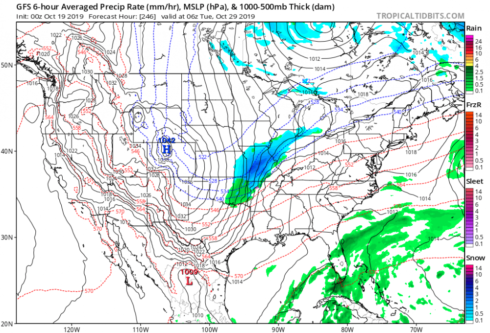
-
MO/KS/AR/OK 2019-2020 Winter Wonderland Discussion
Cerakoter1984 replied to JoMo's topic in Central/Western States
I wrote a longer post but it disappeared. Anyway, great stuff raindancewx. I always enjoy the way you approach forecasting. Very thorough. Well done. -
MO/KS/AR/OK 2019-2020 Winter Wonderland Discussion
Cerakoter1984 replied to JoMo's topic in Central/Western States
Boomer!! We're gonna dominate the little pronghorns today. Sould be a great game. Heck of a way to return from hibernation, my friend! Lol -
MO/KS/AR/OK 2019-2020 Winter Wonderland Discussion
Cerakoter1984 replied to JoMo's topic in Central/Western States
IOD, descending QBO, Modoki atmosphere, in spite of what the surface looks like at this time and that HUGE HUGE storm due north all look fantastic for winter implications this year. As JoMo said, though, stuff could change. Seeing signs of a nice looking Bering Sea low developing in the future as well. I think the signs all point to a go for winter after week three of November down here. That's my honest opinion. -
MO/KS/AR/OK 2019-2020 Winter Wonderland Discussion
Cerakoter1984 replied to JoMo's topic in Central/Western States
Looking forward to the cool blast Thursday and Friday. Should wake us all up a smidge. Glad to see the heat going away. -
2019 ENSO
Cerakoter1984 replied to AfewUniversesBelowNormal's topic in Weather Forecasting and Discussion
So it would be a safe bet to say that any warming in the eastern Niño regions is temporal at best and should likely see more warming going forward in 3.4? Also, do you know where a fellow could find SST reanalysis maps going back throughout the 1900s? I used to have a link to them years ago, but I cannot find it now. Thank you. I'm not on here much but I always like to pop in and read your creative, unique, and intelligent approaches to oceanic/atmospheric matters, raindancewx. -
MO/KS/AR/OK 2019-2020 Winter Wonderland Discussion
Cerakoter1984 replied to JoMo's topic in Central/Western States
Hello. Hope everyone is doing well this autumn. It's hot. Can't wait for it to end.

