

Round Hill WX
-
Posts
412 -
Joined
-
Last visited
Content Type
Profiles
Blogs
Forums
American Weather
Media Demo
Store
Gallery
Posts posted by Round Hill WX
-
-
2 minutes ago, EastCoast NPZ said:
But the models haven't yet ingested the effects of the Tongan volcano eruption!
Unfortunately it was an under water eruption. So ocean temps will be warmer which means we mix and go to all rain.
-
 1
1
-
 1
1
-
 7
7
-
 3
3
-
-
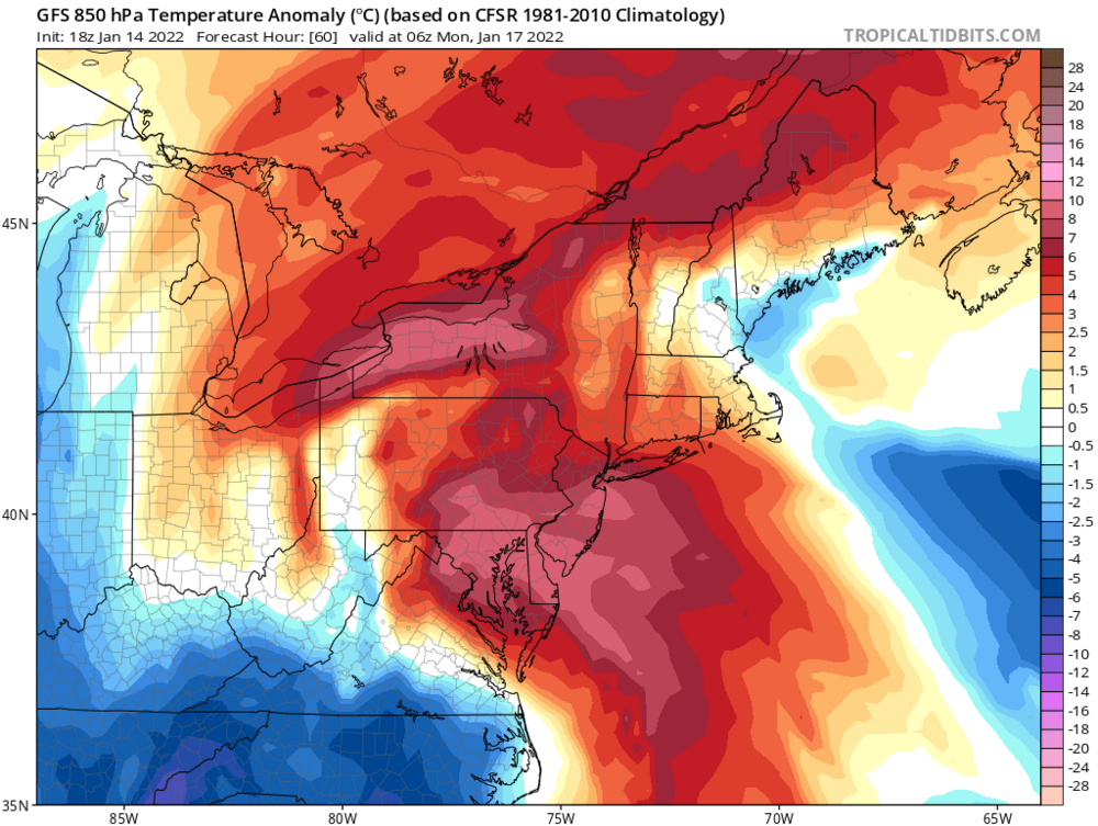
I know it’s January and this is the 850 anomaly, but it pretty much tells the story.
-
1
-
-
9 minutes ago, yoda said:
Alot going on at h5 at 240 though

That is beautiful. Textbook for our area.
-
59 minutes ago, Baltimorewx said:
It looks like the latest guidance is missing this batch of precipitation in northern Virginia. I wonder if there’s ground truth to it. If there is and it holds then freezing rain might materialize for more people
Just enough to cover the deck in Round Hill. 28/21
-
Light snow in Round Hill. 32/26
-
4
-
-
When’s Chuck gonna post a dot matrix northern hemisphere map and tell us this snow ain’t happening again?
-
1
-
4
-
-
2.5” in Round Hill. Snow has ended. 29. I’ll take it.
-
Gonna enjoy whatever happens Wednesday before the mid-month TORCH. But, I don't hate the MJO progression as we head toward Christmas.
-
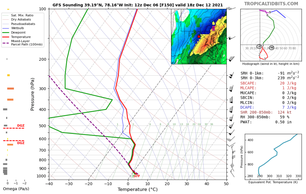
The 12z GFS continues to show a decent storm for next Sunday. Just looking at the precip type map it looks like a pretty good snow event to the NW. However, looking at the sounding, there is nothing but dry air in the dendritic snow growth zone. It's possible that there could be some wet snow to end, but too much dry air works in by the time the column is cold enough for snow. Mostly a rain event.
-
15 minutes ago, MN Transplant said:
That is a sad OP run for getting into early Dec.
I don’t hate all that snow in a cold source region.
-
2
-
-
5 minutes ago, midatlanticweather said:
That was really awesome. There is a ton of lightning in these storms. My son and I were filming but the rain was shielding most of the bolts. I know I got some! That was the best of the season so far out this way.
Yeah it was pretty solid for around here. Even had some pea sized hail.
-
1
-
-
HRRR has been pretty consistent with a short window of discrete cell activity in the immediate DC area ahead of the main line. There is moderate CAPE and nice 0-6km shear as well in this area. This creates a nice MUH streak right thru FFax, DC, and PG.
-
Snow accumulating on the deck. Down to 33/32
-
Rain has changed to wet snow In Round Hill. 36/32
-
1
-
-
Bit late but here ya go! Thanks for putting this together.
Latitude: 39.139663 | Longitude: -77.785095
-
38 minutes ago, Ji said:
the long range looks horrible lol
0z EURO had a nice west based -NAO with well-below 850s around 3/6. The PAC sucked at the same time but not a shut out pattern.
-
 1
1
-
-
1 minute ago, WinterWxLuvr said:
So do we just keep talk of the Friday night snowstorm here?
You should start a thread dude....
-
Nasty freezing mist had commenced in Round Hill.
26/24
Snowblowing done...beer time!
-
I say this in a non-condescending tone...hopefully as a weather nerd community, we have learned this winter the NAMs are very good inside of 36-48 hours...especially with thermal height profiles. @high risk has been a big supporter and advocate for it's benefit and hopefully people will elevate it in their forecasting toolbox.
-
2
-
-
1 minute ago, WVsnowlover said:
Looks like about another 30 minutes of sleet here. How are we looking for a possible 2nd round this evening? Is that still a thing?
NAMS have very light, showery mixed precip through the night out our way. Not much in the way of additional accumulations though.
-
Just now, TSG said:
The amount of complaining in here is comical. This storm looked like it was headed for Buffalo a week ago y'all. Frozen stuff is falling from the sky. Be happy.
Weenies wanted to believe in the PARA so bad...skewed their expectations.
Sleet ongoing here. Still only 24 degrees. My big dilemma right now is when to clear the driveway???
-
MOD/HVY snow. There has been sleet mixed in during lighter precip.
23/23.
2" snow.
Round Hill.
-
2
-
-
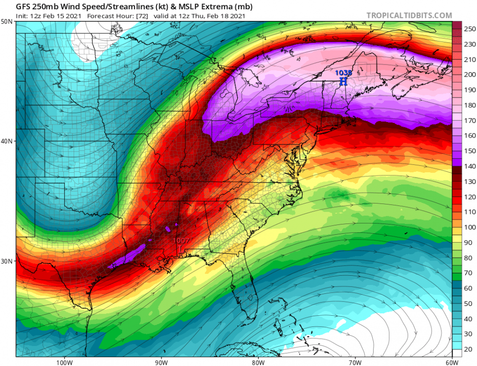
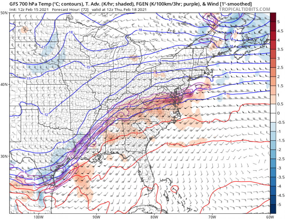
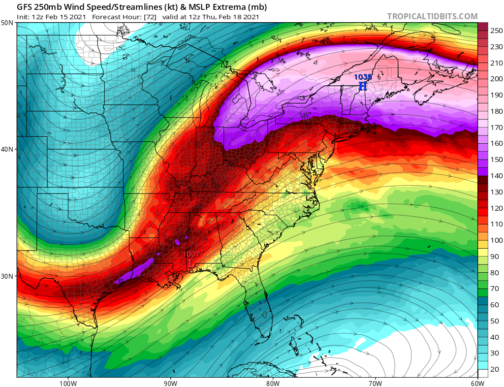
Very nice 700MB advection/frontogenesis in the right quad exit region of the jet on the 12z GFS. Explains the heavy burst graphically.
-
4
-
-
Dang Leesburg all up in PSUs ass this morning!


January 16-17, 2022 MLK storm obs/now cast
in Mid Atlantic
Posted
Radar blockage from Bull Run Mountain