

janetjanet998
-
Posts
6,027 -
Joined
-
Last visited
Content Type
Profiles
Blogs
Forums
American Weather
Media Demo
Store
Gallery
Posts posted by janetjanet998
-
-
you can see that black smoke coming from Rockton chemical plant fire on the visible
-
ULLETIN - EAS ACTIVATION REQUESTED
FLASH FLOOD WARNING
NATIONAL WEATHER SERVICE TULSA OK
1049 AM CDT MON JUN 7 2021
THE NATIONAL WEATHER SERVICE IN TULSA HAS ISSUED A
* FLASH FLOOD WARNING FOR...
OKMULGEE COUNTY IN NORTHEASTERN OKLAHOMA...
* UNTIL 345 PM CDT.
* AT 1049 AM CDT, EMERGENCY MANAGEMENT REPORTED FLOODING IS ONGOING
ACROSS OKMULGEE COUNTY WITH NUMEROUS FLOODED ROADWAYS. BETWEEN 3
AND 7 INCHES WITH LOCAL AMOUNTS NEAR 12 INCHES OF RAIN HAVE FALLEN
SINCE THE EARLY MORNING HOURS. FLASH FLOODING IS ONGOING.
HAZARD...LIFE THREATENING FLASH FLOODING IS ONGOING.
SOURCE...EMERGENCY MANAGEMENT.
IMPACT...LIFE THREATENING FLASH FLOODING OF CREEKS AND STREAMS,
URBAN AREAS, HIGHWAYS, STREETS AND UNDERPASSES. -
another wet day in this area and another MCS over DFW
pattern looks drier after this however
but models hinting at tropical system 8-10 days out in the western gulf
“This is the highest all of the lakes have been all year,” said Greg Waller, a service coordination hydrologist at the Weather Service. “We’re in a persistent rain pattern, and we’re to a point that a thunderstorm that produces an inch of rain is producing flooding.”
He said he has been referring to the recent rainfall as “May 2015-lite.’”
During the 2015 storms, the rainfall was greater and the affected areas were larger.
“We’re getting enough breaks for some of the water to drain downstream,” he said.
-
After the wettest May on record for some areas, parts of Texas and Louisiana prepare for more
Between May 16-22, a weather reporting station south of Lake Charles, Louisiana, tallied over 21 inches of precipitation, while Baton Rouge saw a staggering 15 inches during the same period. Victoria, Texas, received 20.28 inches of rain during the month of May, eclipsing the previous record of 14.66 inches in 1993. With even more rain in the forecast for these hard-hit areas, the same locations will once again face the threat of flooding.
https://amp.cnn.com/cnn/2021/06/03/weather/texas-flooding-louisiana-weekend-rainfall/index.html
-
Slow moving MCS with a WAA arm soaking NW DFW metro
* FLASH FLOOD WARNING FOR...
CENTRAL PARKER COUNTY IN NORTH CENTRAL TEXAS...
NORTHWESTERN TARRANT COUNTY IN NORTH CENTRAL TEXAS...
* UNTIL 800 PM CDT.
* AT 454 PM CDT, TRAINED WEATHER SPOTTERS REPORTED BETWEEN 2 AND 4
INCHES OF RAIN HAVE FALLEN IN THE PAST HOUR NEAR WEATHERFORD.
THESE RAIN TOTALS WILL LIKELY LEAD TO FLASH FLOODING THAT IS
EITHER ONGOING OR EXPECTED TO BEGIN SHORTLY. -
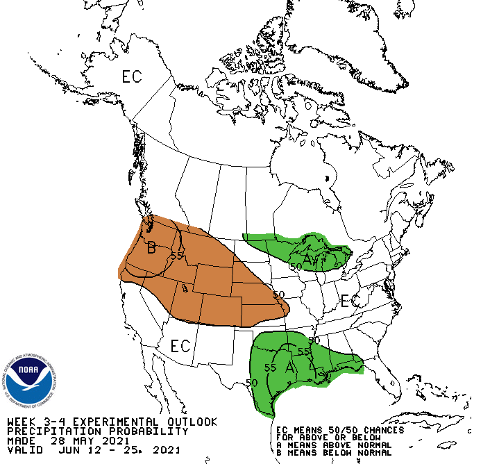
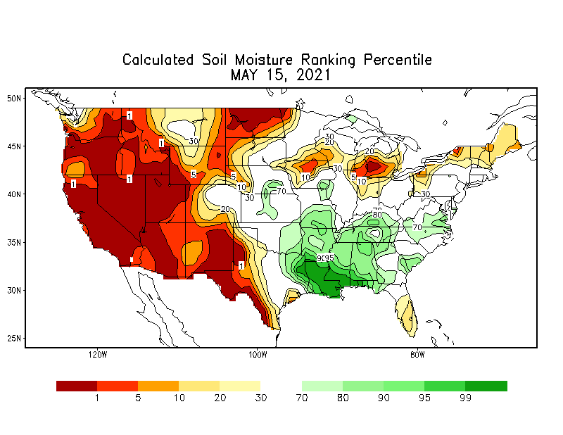
nothing extreme the past 10 days or so ..but above normal precip continued in east TX up into KS/MO
soil moisture wet
no death ridges
more flash flood watches up today
Lakes in DFW area running high and some in flood and parts of the areas closed
any slow tropical systems this summer moving around the SE ridge into the area could be trouble
-
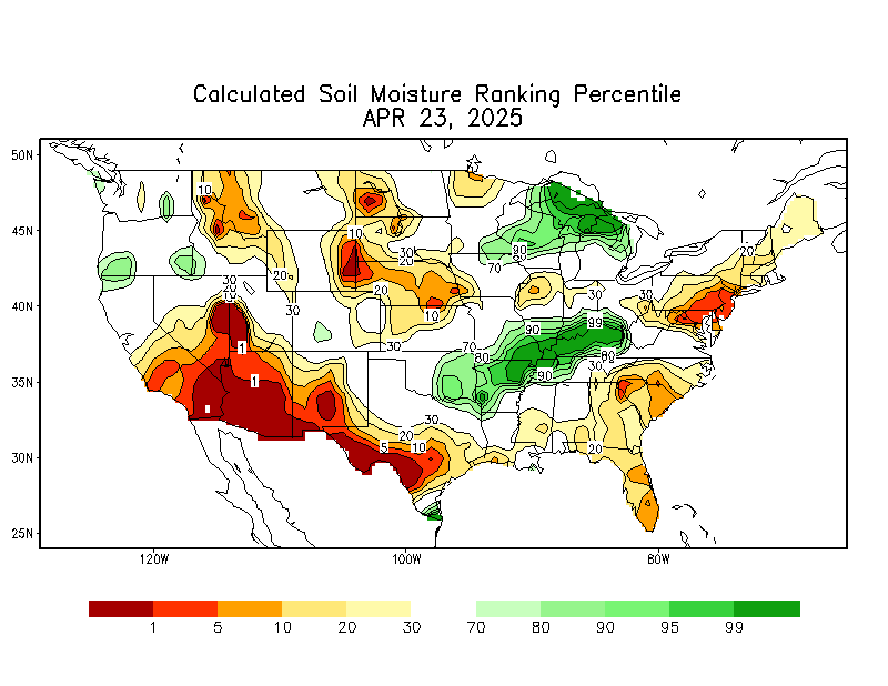
More heavy rain over eastern Texas and LA
Rivers and bayous high
tropical disturbance over Gulf should move into TX with high PW values on its NE flank moving into the area
pattern has has been looked in all spring
soil very wet
any summer tropical systems could mean major flooding'
updated Soil Moisture
 \
\
-
at least the Lakes are dropping
Water levels drop in Great Lakes after record-breaking highs in 2020, years of steady increases
New data from the U.S. Army Corps of Engineers' Detroit office show that all of the lakes have lower levels, with Lake Michigan and Lake Huron showing a drop of 14 inches from the same time last year, while Lake Superior is down about six inches. Lake Ontario experienced the largest drop of 28 inches, while Lake Erie fell 17 inches.
But those numbers don't mean that things have returned to normal, said Deanna Apps, a physical scientist with the Corps. Lake Michigan is still 22 inches above its average level, while Lake Superior is eight inches above average.
-
After 3/4 of an inch yesterday 1.5 inches so far at PIA today
month 5.30 +2.54
since Mar 1 13.26 +3.82
with 8.53 of that since 4-28
3 weeks ago
a far cry form ORDs totals just 160 miles NE
-
southern LA has been extremely wet so far this year
Lake Charles had over a foot yesterday
12.49
New Orleans has been insane this spring
May 11.96 +8.81
Since March 1 34.59 +21.86
-
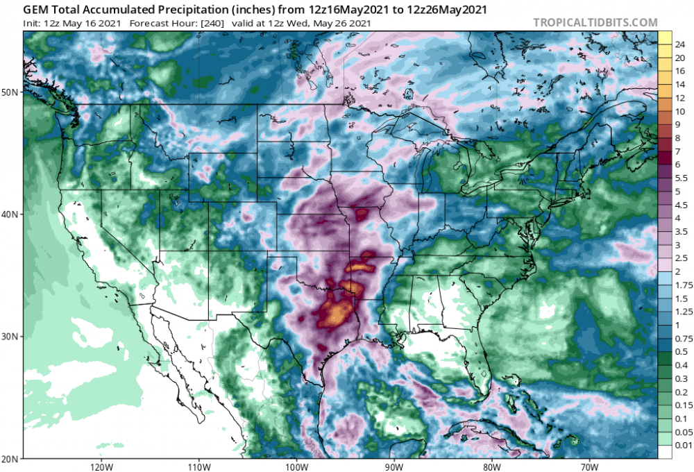
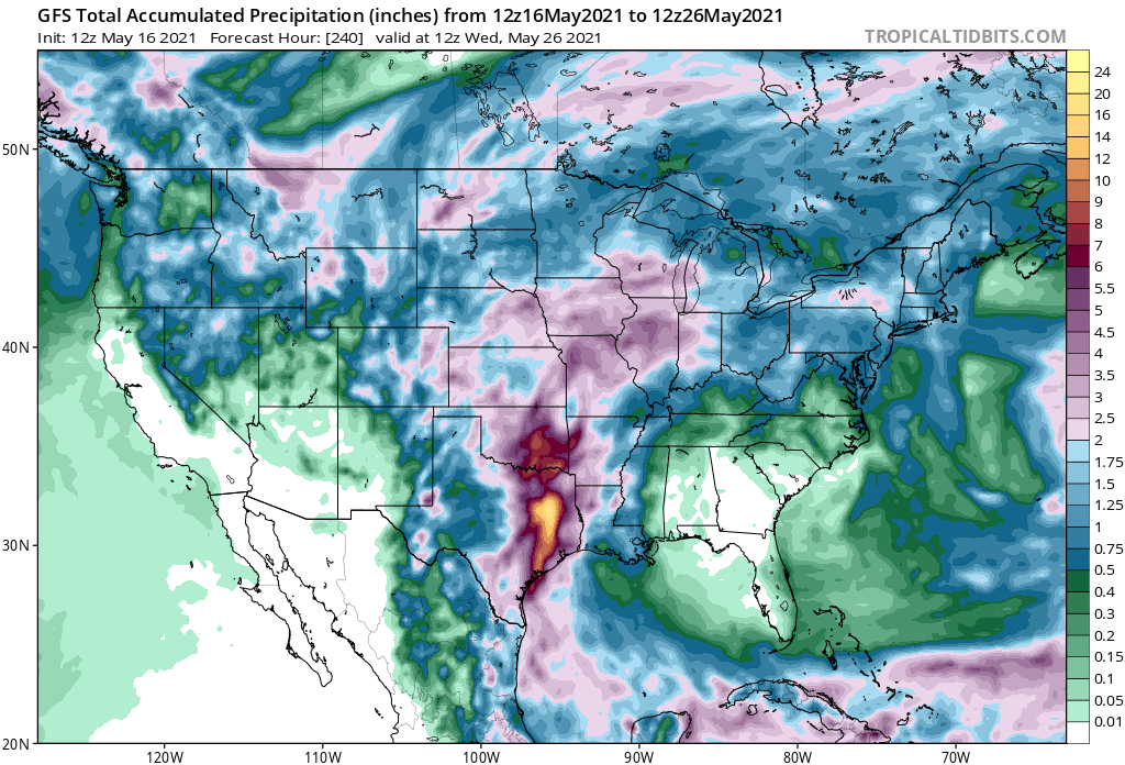
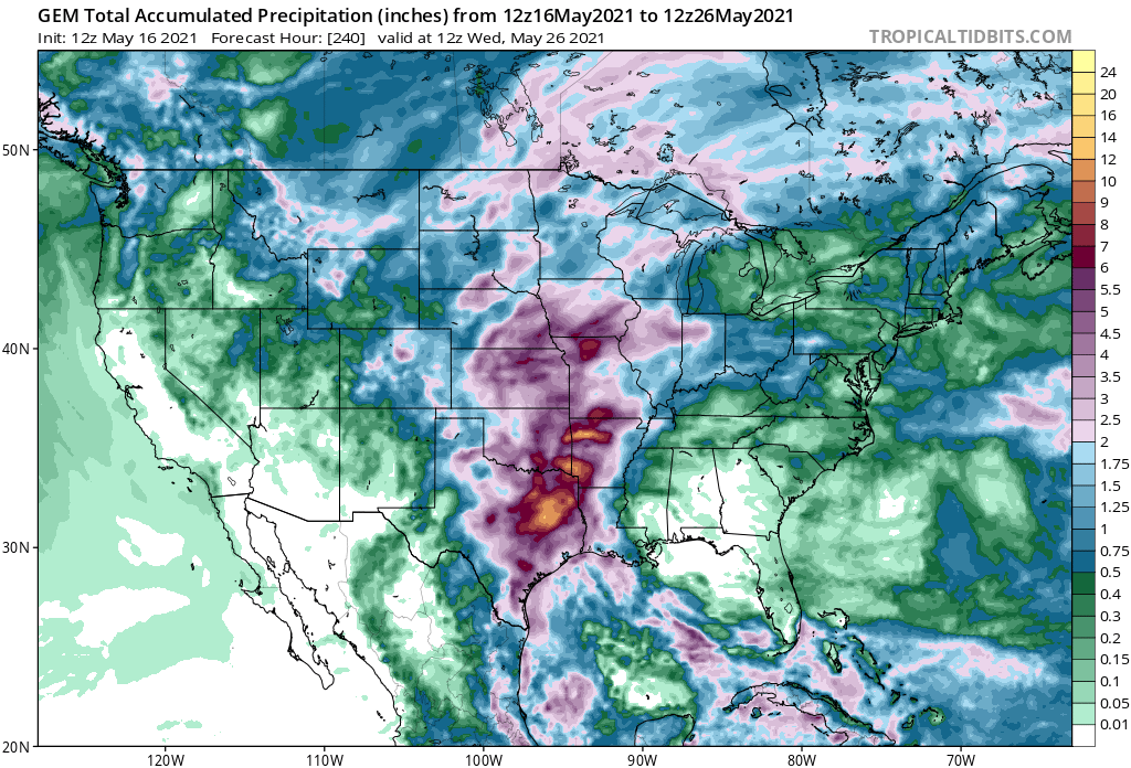
updated total precip map
NW sections got the most rains apst 24 hours
MCS moving into the area

-
it has been raining nonstop , mostly light to semi-moderate at times , non stop since around 3am here
15 hours straight
About 8/10ths at PIA airport
-
 1
1
-
-
Chicago Metro once again has it's precip shields up
with respectable amounts southwest
and heavy rains of 1-3 inches downstate
models say this should continue
about 1/3 of an inch here so far but more south
-
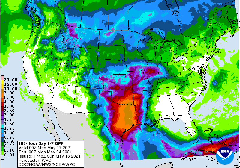
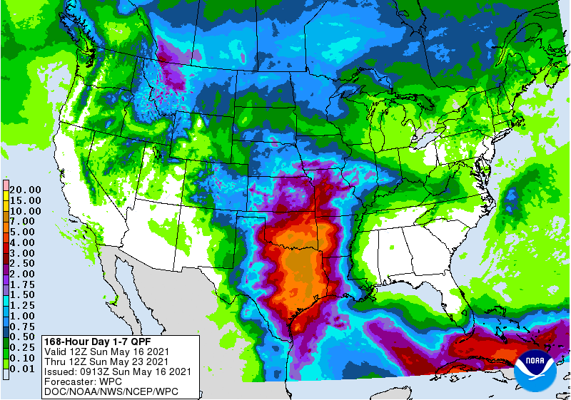
new 7 day ...10 inch pixel again
in the short term a small MCS is SE of Dallas and south of the heavy rain yesterday
DFW getting moderate rains maybe 1/3 to /12 inch this morning but will likely have to wait under tonight for next round of heavy rain based on trends

-
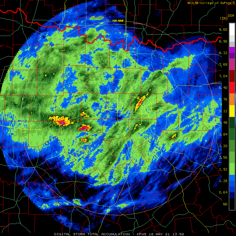
1 hour ago, Powerball said:
Pretty impressive swath of 3"+ rain across NW Dallas County.
I'm interested to see what the rainfaill total will be out of Love Field (maybe upwards of 7"?). It seems to be the bullseye.

5.11 at Love
-
New 7 day...10 inch pixel over TX
keep in mind this doesn't start until after 00z so it doesn't include the rain falling now
-
3 minutes ago, Powerball said:
Welp, this might not have aged well...
DFW airport has gotten the gaps so far this spring
More north and much more southeast metro
have .86 so far today and the band set up SE a few miles
-
Not off to the best start in the multi day event
..Upper Trinity river basin getting hit hard..
Lake lewisville basin also got a good soaking (1-2 inches)
THE NATIONAL WEATHER SERVICE IN FORT WORTH HAS ISSUED A
* FLASH FLOOD WARNING FOR...
WESTERN DALLAS COUNTY IN NORTH CENTRAL TEXAS...
* UNTIL 430 PM CDT.
* AT 122 PM CDT, DOPPLER RADAR INDICATED THUNDERSTORMS PRODUCING
HEAVY RAIN ACROSS THE WARNED AREA. UP TO 4 INCHES OF RAIN HAS
ALREADY FALLEN NEAR I-30 AND LOOP 12. SOME ROADS ARE ALREADY
EXPERIENCING MINOR FLOODING AND CONDITIONS ARE EXPECTED TO WORSEN. -
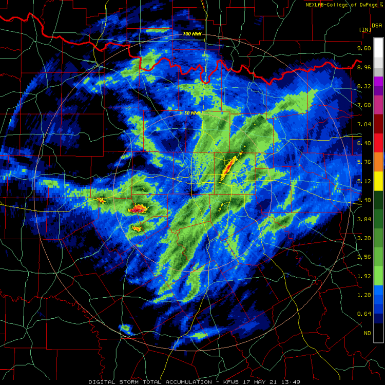
MESOSCALE PRECIPITATION DISCUSSION 0181
NWS WEATHER PREDICTION CENTER COLLEGE PARK MD
1216 PM EDT SUN MAY 16 2021
AREAS AFFECTED...EAST-CENTRAL OKLAHOMA THROUGH NORTH TEXAS
CONCERNING...HEAVY RAINFALL...FLASH FLOODING POSSIBLE
VALID 161615Z - 162115Z
SUMMARY...POTENTIAL FOR FLASH-FLOODING THIS AFTERNOON ALONG A
MOISTURE/INSTABILITY AXIS EXTENDING FROM NORTH TEXAS INTO
EAST-CENTRAL OKLAHOMA.
DISCUSSION...A MID-LEVEL IMPULSE IS LIFTING NORTHEAST THROUGH
CENTRAL OK WITH AN AXIS OF MOISTURE/INSTABILITY EXTENDING NORTH
FROM SOUTH TX AHEAD OF THIS WAVE. SCATTERED THUNDERSTORMS HAVE
DEVELOPED IN THIS AXIS OVER NORTH TEXAS WITH RECENT MAX ONE HOUR
RAINFALL ESTIMATES FROM KFWS OF 1.5 TO LOCALLY 2" OVER THE I-35
CORRIDOR INCLUDING THE DALLAS METRO. PWS OF 1.6" TO 1.7" WILL
CONTINUE TO BE REINFORCED BY 25KT SOUTHERLY 850MB FLOW WITH SBCAPE
OF 500 TO 1000 J/KG. 1HR FFG IS LOWER THROUGH THE DALLAS
METRO/ALONG I-35E (BETWEEN 2.0" AND 2.5"/HR) WHERE THE GREATER
MOISTURE IS PRESENT. FARTHER NORTH IN EAST-CENTRAL OK ARE PWS
AROUND 1.5" AND 1HR FFG IS GENERALLY JUST ABOVE 2.5"/HR. HOWEVER,
THE MID-LEVEL CIRCULATION SHOULD CONTINUE TO ALLOW SOME LONGER
RESIDENCE TIME FOR MODERATE TO HEAVY RAIN, MAKING FOR A SIMILAR
ISOLATED FLASH FLOOD IN PARTS OF CENTRAL OK TO NORTH TX THIS
AFTERNOON.
JACKSON -
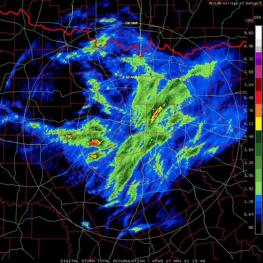
12 model runs next 10 days

-
43 minutes ago, weatherextreme said:
Trinity river will be one to watch. If DFW gets flooding rains, the area around the Trinity river typically will have big problems.
started a new thread about heavy rain/flooding so this thread can focus on tornadoes, hail, wind, etc
-
1
-
-
Tropical fire house into eastern/central TX then and north
Flash Flood watches up for the next 3 days in places including DFW
Most of the drought is west of this area and some places have already been wet this spring
Soil Moisture neutral/slightly above average but well above NE Texas
7 day precip
-
1
-
-
3 minutes ago, weatherextreme said:
Trinity river will be one to watch. If DFW gets flooding rains, the area around the Trinity river typically will have big problems.
will depend on meso features of course and luck with overlapping events
but it Looks like a mini train is setting up for Dallas county and SE Metro for round 1
-
1 hour ago, Iceresistance said:
I've never seen the Day 3 outlook feature a Moderate risk of Flooding that does NOT feature a Tropical Cyclone!
The WPC QPF is going crazy!
How about 3 day Flash Flood watch
Dallas
.FLASH FLOOD WATCH IN EFFECT FROM 7 AM CDT THIS MORNING THROUGH
WEDNESDAY MORNING...This might need it's own thread
more rainfall after the 3 day map you posted
2015 redux?
Lake Lewisville Dam problems if Denton County gets hit bad??
June 20th, 2021 Severe Weather Event
in Lakes/Ohio Valley
Posted
For some reason the developing convection in MO that the meso was issued for turned into a moderate rain blob
what a waste of a 60kt 500mb speed max so far
sometimes mini discrete storms can develop within this but so far nothing