

janetjanet998
-
Posts
6,027 -
Joined
-
Last visited
Content Type
Profiles
Blogs
Forums
American Weather
Media Demo
Store
Gallery
Posts posted by janetjanet998
-
-
warning says PDS tornado
but radar indicated?
-
Damn
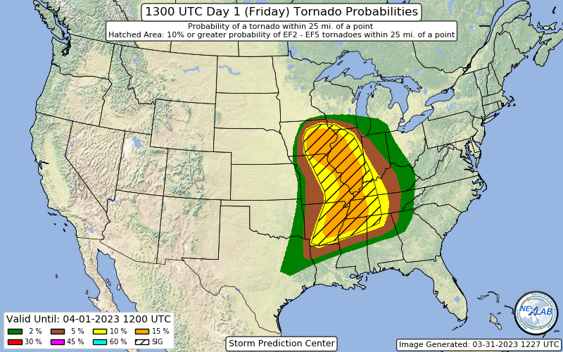
URGENT - IMMEDIATE BROADCAST REQUESTED
TORNADO WATCH NUMBER 93
NWS STORM PREDICTION CENTER NORMAN OK
1145 AM CDT FRI MAR 31 2023
THE NWS STORM PREDICTION CENTER HAS ISSUED A
* TORNADO WATCH FOR PORTIONS OF
CENTRAL AND EASTERN IOWA
WESTERN ILLINOIS
NORTHERN AND CENTRAL MISSOURI
SOUTHWEST WISCONSIN
* EFFECTIVE THIS FRIDAY MORNING AND EVENING FROM 1145 AM UNTIL
800 PM CDT.
..THIS IS A PARTICULARLY DANGEROUS SITUATION
* PRIMARY THREATS INCLUDE...
NUMEROUS TORNADOES EXPECTED WITH A FEW INTENSE TORNADOES LIKELY
WIDESPREAD LARGE HAIL AND ISOLATED VERY LARGE HAIL EVENTS TO 3
INCHES IN DIAMETER LIKELY
WIDESPREAD DAMAGING WIND GUSTS TO 70 MPH LIKELY
SUMMARY...INTENSE SUPERCELL THUNDERSTORMS ARE EXPECTED TO DEVELOP
THIS AFTERNOON AND SPREAD EASTWARD ACROSS THE WATCH AREA.
TORNADOES, LARGE HAIL, AND DAMAGING WINDS ARE ALL POSSIBLE WITH THIS
ACTIVITY. PARAMETERS ARE FAVORABLE FOR THE POTENTIAL FOR
STRONG/VIOLENT TORNADOES AND VERY LARGE HAIL. -
2 minutes ago, Chicago916 said:
Funny that a large blob of clouds is over the northern High Risk zone. That isn't going to affect the instability there?
it's an old dead thunderstorm anvil that is thinning and moving fast so not much
-
 2
2
-
-
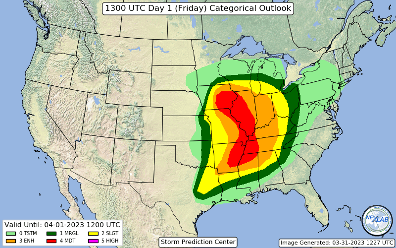
They connected the MOD risk areas
-
Convection firing in SE Kansas with the first wave
new SPC
..MIDWEST AND THE MID-MS TO OH VALLEYS A 992-MB CYCLONE OVER EASTERN NE WILL DEEPEN THROUGH THIS AFTERNOON AS IT MATURES INTO THE UPPER MS VALLEY BEFORE OCCLUDING THIS EVENING. A PLUME OF SURFACE-BASED BUOYANCY SUPPORTED BY MID 50S TO 60S DEW POINTS ACROSS THE MID-MO VALLEY TO THE SOUTHERN GREAT PLAINS WILL SHIFT EAST INTO THE MID TO LOWER MS VALLEYS THROUGH THE DAY. GUIDANCE IS FAIRLY CONSISTENT THAT INITIALLY ELEVATED CONVECTION SHOULD INCREASE IN THE OZARKS VICINITY BY LATE MORNING ALONG THE EASTERN GRADIENT OF THE DEEPER BUOYANCY PLUME AS A LOBE OF LOW-LEVEL ASCENT SPREADS NORTHEAST DOWNSTREAM OF THE VIGOROUS CENTRAL TO SOUTHERN HIGH PLAINS SHORTWAVE TROUGH. WHILE THIS LEAD ACTIVITY WILL HAVE AT LEAST A LARGE HAIL THREAT, HOW THE OTHER HAZARDS EVOLVE DOWNSTREAM INTO THE AFTERNOON ACROSS THE MS RIVER INTO IL IS QUITE UNCERTAIN GIVEN LARGE SPREAD IN GUIDANCE WITH OVERALL COVERAGE/INTENSITY, ALONG WITH PRONOUNCED DIFFERENCES IN HOW QUICKLY SURFACE-BASED DESTABILIZATION OCCURS TO THE EAST.
THE PRIMARY SEVERE EVOLUTION REMAINS LIKELY TO EVOLVE BEGINNING AROUND 19Z TO THE SOUTHEAST OF THE DEEP CYCLONE ACROSS CENTRAL IA AND BROADENING IN COVERAGE THROUGH THE LATE AFTERNOON ALONG THE NORTH/SOUTH-ORIENTED COLD FRONT ARCING SOUTHWARD INTO EASTERN MO. VERY STEEP MID-LEVEL LAPSE RATES AND AN ELONGATED MID TO UPPER-LEVEL HODOGRAPH WILL INITIALLY SUPPORT A BROKEN BAND OF SUPERCELLS CAPABLE OF PRODUCING VERY LARGE HAIL. AS ACTIVITY RAPIDLY SPREADS INTO AN INCREASINGLY FAVORABLE LOW-LEVEL SRH ENVIRONMENT IN EASTERN IA AND THE MS VALLEY, SEVERAL TORNADOES ARE EXPECTED TO FORM, A FEW OF WHICH COULD BE STRONG AND LONG-TRACKED. THERE SHOULD BE AN ADEQUATE GAP BETWEEN THE LEAD AND PRIMARY ROUNDS OF CONVECTION TO SUPPORT SCATTERED SUPERCELLS THROUGH AT LEAST EAST-CENTRAL MO INTO MOST OF IL INTO EARLY EVENING. WITHIN A 3-6 STP ENVIRONMENT AND THE CORE OF THE 500-700 MB JETS UPSTREAM THERE WILL BE A THREAT FOR A COUPLE, LONG-TRACKED SUPERCELLS CAPABLE OF PRODUCING STRONG TO POTENTIALLY VIOLENT TORNADOES.
-
4 hours ago, StormChaser4Life said:
It's consistently taking a robust helicity track right through Peoria where I live. Storm mode definitely more discrete to semi discrete versus more clustered towards Iowa. Is this forming on a lead wave or just on the lead edge of the exit region of the jet? Seems like this first wave may be the more robust tornado threat with a potential 2nd round associated more with cf which looks more qlcs variety albeit still showed supercell characteristics and some broken quality to line.
Shades of big Dixie Alley outbreaks with 2 waves with the lead wave having winds backed more ahead of it
-
1
-
-
ILX pulled the trigger
INCLUDING THE CITIES OF GALESBURG, TOULON, PEORIA, LACON, EUREKA, CANTON, PEKIN, BLOOMINGTON, NORMAL, RUSHVILLE, HAVANA, LINCOLN, CLINTON, BEARDSTOWN, PETERSBURG, WINCHESTER, JACKSONVILLE, SPRINGFIELD, TAYLORVILLE, AND DECATUR 332 PM CST MON DEC 19 2022 ...WINTER STORM WATCH IN EFFECT FROM THURSDAY MORNING THROUGH LATE FRIDAY NIGHT... * WHAT...BLIZZARD CONDITIONS POSSIBLE. SNOW ACCUMULATIONS OVER 3 INCHES POSSIBLE. WINDS COULD GUST AS HIGH AS 50 MPH.
-
2
-
-
4 hours ago, janetjanet998 said:
IF the current storms over NE IL become the WAA wing of that MN complex ..get your boats ready
you can perhaps see weak signs of this starting on the visible (connecting clouds back into MN)
EXCESSIVE RAINFALL DISCUSSION
NWS WEATHER PREDICTION CENTER COLLEGE PARK MD
304 PM EDT SAT JUL 23 2022

DAY 1
VALID 1745Z SAT JUL 23 2022 - 12Z SUN JUL 24 2022

...THERE IS A MODERATE RISK OF EXCESSIVE RAINFALL NEAR THE
ILLINOIS/INDIANA BORDER...
ONGOING CONVECTION ACROSS NORTHEAST IL AND NORTHWEST IN WHICH HAS DROPPED A GROWING FOOTPRINT OF 3-6" OF RAINFALL LED TO A TARGETED MODERATE RISK NEAR THE IL/IN BORDER, WHERE ONGOING RAINFALL AND RAINFALL LATER TODAY COULD EXACERBATE ISSUES. THE GAP BETWEEN THE BACKBUILDING ACTIVITY IN IL/IN AND WHAT'S INCOMING ACROSS SOUTHERN MN/NORTHWEST IA IS NARROWING -- THERE'S INCREASING CONCERN THAT ANY GAP IN THE HEAVY RAINFALL WILL BE MINIMAL, IF AT ALL. THERE IS POTENTIAL FOR CONTINUED TRAINING IN EITHER A GENERALLY WEST TO EAST OR WEST-NORTHWEST TO EAST-SOUTHEAST DIRECTION THROUGH THE PERIOD IN THE VICINITY OF AT LEAST THREE CONVECTIVE ROUNDS --
-
IF the current storms over NE IL become the WAA wing of that MN complex ..get your boats ready
you can perhaps see weak signs of this starting on the visible (connecting clouds back into MN)
-
MOD risk coming today
edit: Chicago lucked out the other day, really thought that storm was going to drop a strong tornado as it moved SE along that front
-
1
-
-
19 minutes ago, Crispus said:
Local media reporting 6.5" official total for Peoria.
I still don't get where they determine the official total is from
for years(decades) it was the spotter just SW of the airport
if you type in the coordinates in the LSR 40.76N 89.60W it says Donavon Park this time
but other times it has been the Health department and once even Peoria Heights Tower Park among others
they seem to jump around
-
1
-
-
got to be 2 inch per hour rates here in that last intense band..huge flakes
won't last long though
-
1 minute ago, StormChaser4Life said:
So here's the million dollar question. Will the nam/gfs/hrrr/rap camps be right with stronger and more nw or will weaker and se euro prevail? It does have support from other foreign guidance. I'm honestly not sure what to think.
For some reason I foresee an overachieving sleet storm for us
-
LOT talks about the fire causing more snow downwind and plane exhaust from O'Hare doing the same thing
also there seems to be a band of weak returns downwind of the Gary IND plant into eastern will county all day
SOME OF THESE
SHOWERS IN MAINLY DUPAGE COUNTY HAVE APPEARED TO BE SPAWNED FROM
AIRCRAFT EXHAUST WITH THE ADDED NUCLEI SUPPORTING SNOW CRYSTAL
FORMATION. WE SEE THIS AT TIMES WHEN CLOUDS ARE AT THE COLD END OF
THE SUPERCOOLED LIQUID ZONE (-7 TO -11C) AND THAT'S WHAT AMDAR
SOUNDINGS ARE INDICATING RIGHT NOW. THESE SNOW SHOWERS HAVE
PRODUCED BRIEF MODEST RATES PER SOCIAL MEDIA REPORTS, BUT LAST
FOR A VERY QUICK DURATION DUE TO THE RAPID ADVECTION OF THE
SHOWERS IN THE NORTH-NORTHEAST FLOW. CANNOT RULE OUT A DUSTING
UNDER THESE THOUGH.
ALSO OF NOTE, IF LOOKING AT OUR RADAR ONE WILL NOTICE A PLUME
EMANATING FROM NORTHWEST DUPAGE COUNTY, AND THAT IS CONCENTRATED
SMOKE FROM A FIRE AT A LARGE RECORDS STORAGE FACILITY NEAR
BARTLETT, PER REPORTS FROM EMERGENCY MANAGEMENT. ANALYZING THE
RADAR REFLECTIVITY AND CORRELATION COEFFICIENT, IT IS POSSIBLE
SOME OF THIS IS ALSO CREATING NUCLEI FAVORABLE FOR SNOW SHOWERS
AS IT RISES INTO THE CLOUD LAYER. THIS LOOKS TO BE OVER SOUTHERN
KANE AND NORTHERN KENDALL COUNTIES. -
2 minutes ago, janetjanet998 said:
interesting this was from 5 hours ago...i wonder why it started to really show up on the radar only recently
Northern Illinois Scanner Incidents
@nisi_alerts
·
5h
Bartlett, DuPage County
1200 Humbracht Cir, Access Records Storage
2 Alarm Commercial Structure Fire
Defensive Operations in progress
Shan, PharmD
@shanpharmd
·
14m
Replying to
@PogiPR
and
@ABC7Chicago
Wow I wonder what happened? We heard 3 explosions all of which shook the house. -
interesting this was from 5 hours ago...i wonder why it started to really show up on the radar only recently
Northern Illinois Scanner Incidents
@nisi_alerts
·
5h
Bartlett, DuPage County
1200 Humbracht Cir, Access Records Storage
2 Alarm Commercial Structure Fire
Defensive Operations in progress -
1 minute ago, tuanis said:
That radar makes it look like something exploded in Bartlett. Looks like Brewster Creek Business Park. That's mostly warehouse/distribution/food users though.
was going to check on the LES (wimpy) and I saw that
searched twitter for explosion or fire but nothing
came here to check and i see others noticed it
-
8 minutes ago, WeatherMonger said:
Commented before I read this post, but schools will still remain closed I'm sure.
On a related note
Peoria City schools on remote learning today and tomorrow
Kids can't even have a snow day when school is cancelled anymore thanks to the aftermath of COVID times
That would suck from their point of view
-
 1
1
-
-
12 minutes ago, janetjanet998 said:
it's over here , not sure why ILX still has me under a winter storm warning thru tomorrow
had about 10-12 inches in the city isolated spots up to 13 in the metro
I suspect ILX will downgrade soon to a WAA for blowing snow and maybe another inch
it stopped snowing here about 5 hours ago and may not snow again
Lots schools and other places closing again tomorrow partly because of the winter storm warning for up to 6 more inches
a complete joke
it was evident 24 hours ago the 2nd system was trending south and I even mentioned if ILX would downgrade the 2nd half of the almost 48 hour winter storm warning in the other thread
but to keep it going in the new zones this afternoon is just pathetic and will be a another example of "the weatherman always gets it wrong"
as I was typing
URGENT - WINTER WEATHER MESSAGE
NATIONAL WEATHER SERVICE LINCOLN IL
903 PM CST WED FEB 2 2022
ILZ027>030-036-031115-
/O.CAN.KILX.WS.W.0001.000000T0000Z-220204T0000Z/
/O.NEW.KILX.WW.Y.0004.220203T0303Z-220204T0000Z/
KNOX-STARK-PEORIA-MARSHALL-FULTON-
INCLUDING THE CITIES OF GALESBURG, TOULON, PEORIA, LACON,
AND CANTON
903 PM CST WED FEB 2 2022
..WINTER WEATHER ADVISORY IN EFFECT UNTIL 6 PM CST THURSDAY
..WINTER STORM WARNING IS CANCELLED
* WHAT...BLOWING AND DRIFTING SNOW. ANY ADDITIONAL SNOW
ACCUMULATIONS UNDER ONE INCH.
* WHERE...KNOX, STARK, PEORIA, MARSHALL AND FULTON COUNTIES.
* WHEN...UNTIL 6 PM CST THURSDAY.
-
47 minutes ago, mimillman said:
Honestly at this rate if I had to guess it’s going to be Peoria or the near north side
it's over here , not sure why ILX still has me under a winter storm warning thru tomorrow
had about 10-12 inches in the city isolated spots up to 13 in the metro
I suspect ILX will downgrade soon to a WAA for blowing snow and maybe another inch
it stopped snowing here about 5 hours ago and may not snow again
Lots schools and other places closing again tomorrow partly because of the winter storm warning for up to 6 more inches
a complete joke
it was evident 24 hours ago the 2nd system was trending south and I even mentioned if ILX would downgrade the 2nd half of the almost 48 hour winter storm warning in the other thread
but to keep it going in the new zones this afternoon is just pathetic and will be a another example of "the weatherman always gets it wrong"
-
10-12 inches over the city about done
tomorrow a miss south
-
1200 PM HEAVY SNOW 3.0 SW MIDWAY AIRPORT 41.74N 87.78W
02/02/2022 M9.5 INCH COOK IL CO-OP OBSERVER
STORM TOTAL 9.5 INCHES, 5.3 IN THE PAST 6
HOURS.1200 PM HEAVY SNOW NWS CHICAGO-ROMEOVILLE 41.60N 88.08W
02/02/2022 M8.9 INCH WILL IL OFFICIAL NWS OBS
STORM TOTAL 8.9 INCHES, 4.5 INCHES IN THE
PAST 6 HOURS.1200 PM HEAVY SNOW OHARE AIRPORT 41.98N 87.90W
02/02/2022 M5.0 INCH COOK IL OFFICIAL NWS OBS
STORM TOTAL 5.0 INCHES, 3.5 IN THE PAST 6
HOURS.-
1
-
 1
1
-
-
13 minutes ago, Crispus said:
Sample picture of I-74 through Peoria from an hour ago (source: Facebook)
I use this for roads..local traffic cams click the camera icon in the map box upper left
-
1
-
-
Good start for LOT
..REMARKS..
1200 AM SNOW NWS CHICAGO-ROMEOVILLE 41.60N 88.08W
02/02/2022 M1.4 INCH WILL IL OFFICIAL NWS OBS
ACCUMULATION BEGAN AROUND 1030PM.
1200 AM SNOW OHARE AIRPORT 41.98N 87.90W
02/02/2022 M0.2 INCH COOK IL OFFICIAL NWS OBS
-
3
-
March 31st Severe Threat
in Lakes/Ohio Valley
Posted