

monsoonman1
-
Posts
211 -
Joined
-
Last visited
About monsoonman1

- Birthday May 28
-
Central/Western Medium-Long Range Discussion
monsoonman1 replied to andyhb's topic in Central/Western States
Sunday looks at least somewhat intriguing for OK/TX on last night's Euro. Sent from my SM-G920V using Tapatalk -
Central/Western Medium-Long Range Discussion
monsoonman1 replied to andyhb's topic in Central/Western States
Day 3 slight risk issued for SE AR/NE LA/west MS with few tornadoes possible. Also mention of a cold-core type threat in east KS, which I've had my eye on for a few days. Sent from my SM-G920V using Tapatalk -
Central/Western Medium-Long Range Discussion
monsoonman1 replied to andyhb's topic in Central/Western States
12z GFS has trough after trough swinging through the middle of the country from this weekend on, which is about all we can ask for right now. -
Central/Western Medium-Long Range Discussion
monsoonman1 replied to andyhb's topic in Central/Western States
Wouldn't sleep on Saturday, still some questions but parameters seem to be there. Sent from my SM-G920V using Tapatalk -
Central/Western Medium-Long Range Discussion
monsoonman1 replied to andyhb's topic in Central/Western States
SPC has outlined Day 6 from east TX into AR and MS/AL. Only thing holding the setup back right now is lack of instability, but that could easily change so better keep an eye on this.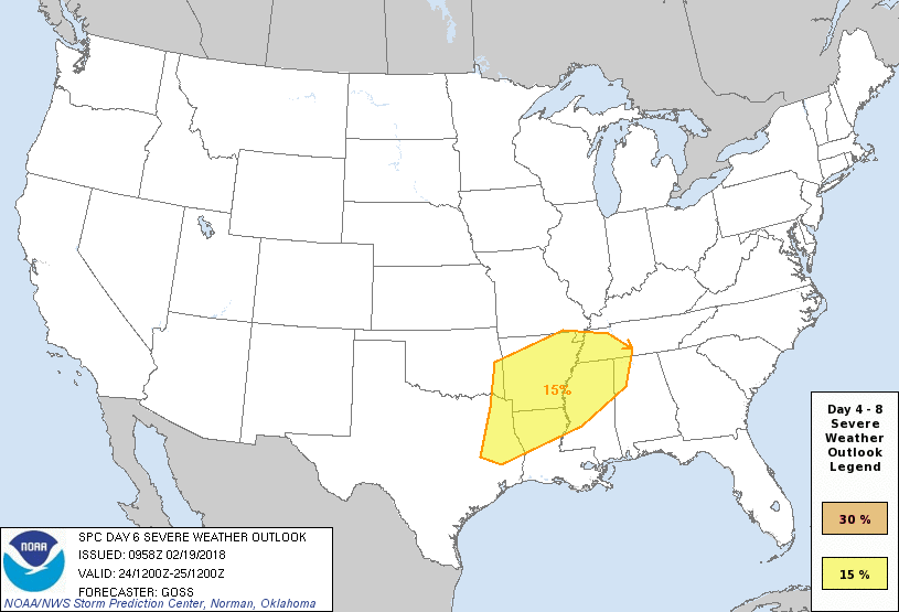
-
Central/Western Medium-Long Range Discussion
monsoonman1 replied to andyhb's topic in Central/Western States
12z GFS also starting to look better. Guessing some folks will get their first chase on Monday. Sent from my SM-G920V using Tapatalk -
MO/KS/AR/OK 2019-2020 Winter Wonderland Discussion
monsoonman1 replied to JoMo's topic in Central/Western States
Kind of a surprise WWA for this morning with 1-2 inches of snow expected IMBY. -
MO/KS/AR/OK 2019-2020 Winter Wonderland Discussion
monsoonman1 replied to JoMo's topic in Central/Western States
Topeka reported 1.3 inches of snow today, makes it 1.8 for the season so far. Hope we can squeeze out some more before the New Year. Sent from my SM-G920V using Tapatalk -
MO/KS/AR/OK 2019-2020 Winter Wonderland Discussion
monsoonman1 replied to JoMo's topic in Central/Western States
GFS snow depth chart has me around 20 inches on 12/27. I'll gladly take that run. Sent from my SM-G920V using Tapatalk -
MO/KS/AR/OK 2019-2020 Winter Wonderland Discussion
monsoonman1 replied to JoMo's topic in Central/Western States
This is a really boring pattern. Sunny with dry cold frontal passages every now and then. At least Friday should be warm enough to go for a hike. Sent from my SM-G920V using Tapatalk -
MO/KS/AR/OK 2019-2020 Winter Wonderland Discussion
monsoonman1 replied to JoMo's topic in Central/Western States
Looks like I had .3 in or so of snow today. Not sure when Topeka last had snow on Halloween. Sent from my SM-G920V using Tapatalk -
Plains States Observations and Discussion Thread
monsoonman1 replied to lookingnorth's topic in Central/Western States
Had a brief blast of snow/sleet in Lawrence, KS. Melted as it hit the ground. -
5% tornado probabilities for parts of NW TX and SW OK. I'd imagine some chasers will be out.
