

dj3
-
Posts
619 -
Joined
-
Last visited
Content Type
Profiles
Blogs
Forums
American Weather
Media Demo
Store
Gallery
Posts posted by dj3
-
-
NWS has this starting pretty early in the day. I was hoping to get home from work in time for the heavy stuff but it may come during the PM commute.
-
 1
1
-
-
NWS going 5-8 it looks like.
-
 1
1
-
-
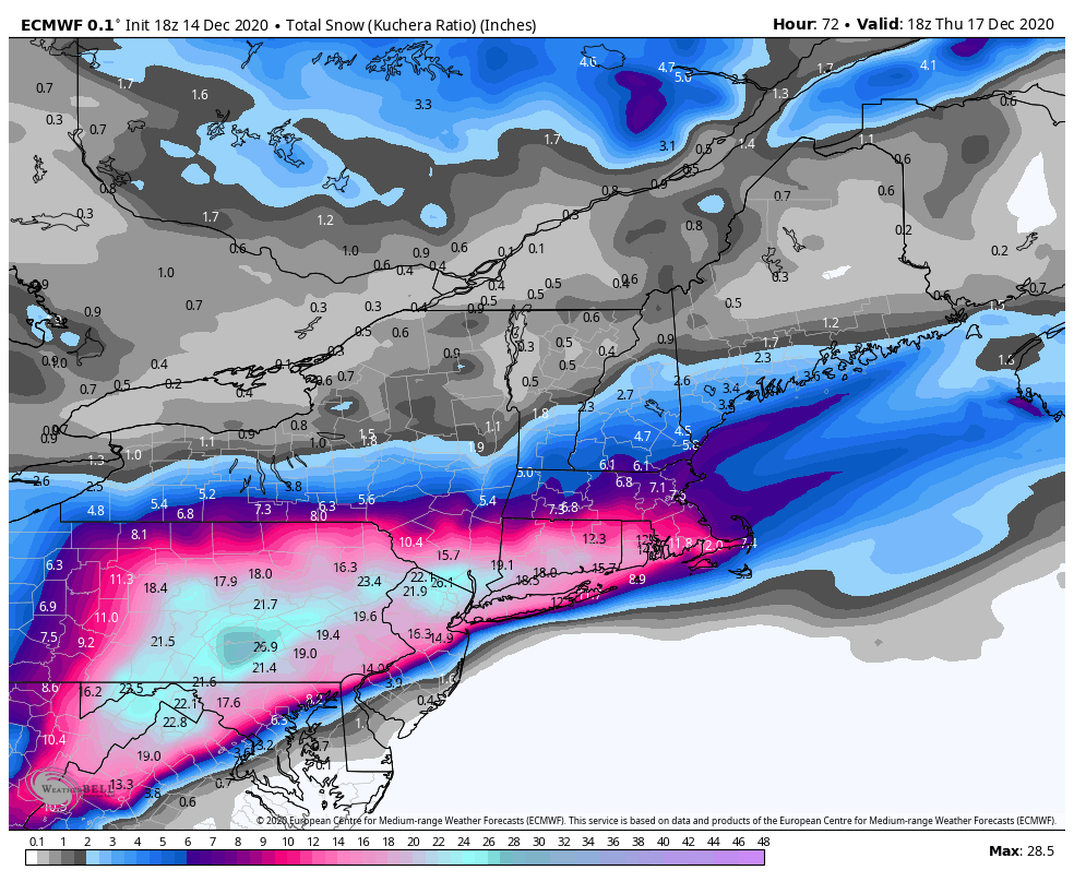
Boom Euro! Keeps throwing goodies back well west.
-
1
-
-
Euro looking good
-
1
-
-
2 minutes ago, Ahoff said:
When will NWS Pittsburgh update? All this data and they’re still on the update from 4 am.
I doubt we will see them go much higher than an incremental bump. Which is fine at this stage, I'm ok with watching the models for an overperformer.
-
1
-
-
GFS coming to the party a little late it looks like. Continued great trends today couldn't be happier.
-
5 minutes ago, Rd9108 said:
Lmao we go from worrying about missing to the east to the dreaded warm tongue of death showing up. Let's see what the other models do.
This is how we do our big ones, we watch the mix line slowly creep towards us on radar.
-
10 minutes ago, ChalkHillSnowNut said:
What’s that little tongue of reduced totals in fayette county? Is that mixing issues or the LP transferring energy right there?....
On the euro I don't think it is mixing issues but moreso the CCB sets up the best banding north of Allegheny count even and keeps it cranking a little longer. From the 850 temps it doesn't look like anything goes above 0 in PA. The most recent NAM run did show some mixing inch it's way just across the border.
-
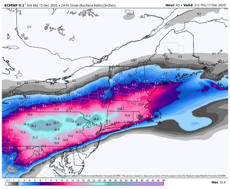
Loving the expansion to the west from the CCB
-
1
-
-
Liking the trends from overnight. I see we've got the NAM back on our side with a nice little jackpot over Westmoreland county LOL.
-
6 minutes ago, CoraopolisWx said:
I would say the overall feel of this storm reminds me a little bit of Jan 1996 and Jan 2016. Hopefully the Jan 1996 part carries more weight.
Was thinking about both of these. For some reason I like where we sit. If dc is dealing with mixing issues I’d be pretty surprised if we didn’t get significant precip thrown back this way for a storm of this magnitude. Jan 2016 was a pretty sharp cut off north to south and this one appears more west to east.
-
8 minutes ago, KPITSnow said:
Someone posted the Euro ensembles in the Mid atlantic forums and there are a TON that are tracking well inland and west of the OP, far more than the few eastern outliers. If that is any sort of indicator it could mean a much bigger hit back our way.
Yep saw that with the low pressure panels as well!
-
1
-
-
From mid Atlantic forum...
-
3
-
-
-
Rpm. Hug the model that gives us most haha
-
3
-
 1
1
-
-
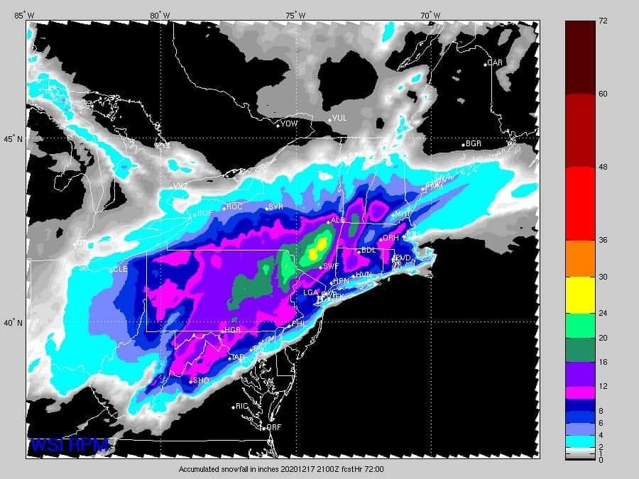
Rgem brought the heavy snow axis a little west from 12z as it looks like the low was more tucked.
-
2
-
-
6 minutes ago, MikeB_01 said:
I think the precip coming down a little bit is due to the trough being a little flatter than it was on previous runs. Regardess of what the snowfall totals are on this run, the energy remained relatively the same
Definitely a flatter look overall looping the last few runs at 500. Question is does it continue trending that way or has it finished correcting it's bias. I'd be happy if we could lock that up as the end result haha.
-

More in line with other guidance
-
Looks like it cut back pretty significantly on precipitation even though the low pressure was stronger.
-
I'm pretty surprised they are using temperature as an excuse to limit impact potential. Models look plenty cold enough and I would think even our best rates are looking to happen later afternoon - midnight?
-
1
-
-
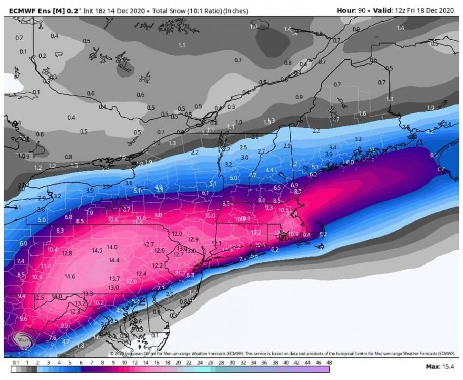
EPS mean looks to be about 6 inches, slightly worse than the OP.
-
Hopefully the EURO and NAM aren't over-doing QPF amounts.
-
1
-
-
Although the snow maps didn't change much on the GFS, the 12z low placement does look further west so I think it is actually a step in the right direction.
-
2
-
-
So at this point EURO and NAM vs GFS/Canadian?

Western Pa / Pittsburgh area Winter Discussion ❄️☃️
in Upstate New York/Pennsylvania
Posted
Gfs has been playing catch up the whole time. At this point I’m looking elsewhere at mesos and euro