

dj3
-
Posts
619 -
Joined
-
Last visited
Content Type
Profiles
Blogs
Forums
American Weather
Media Demo
Store
Gallery
Posts posted by dj3
-
-
9 minutes ago, RitualOfTheTrout said:
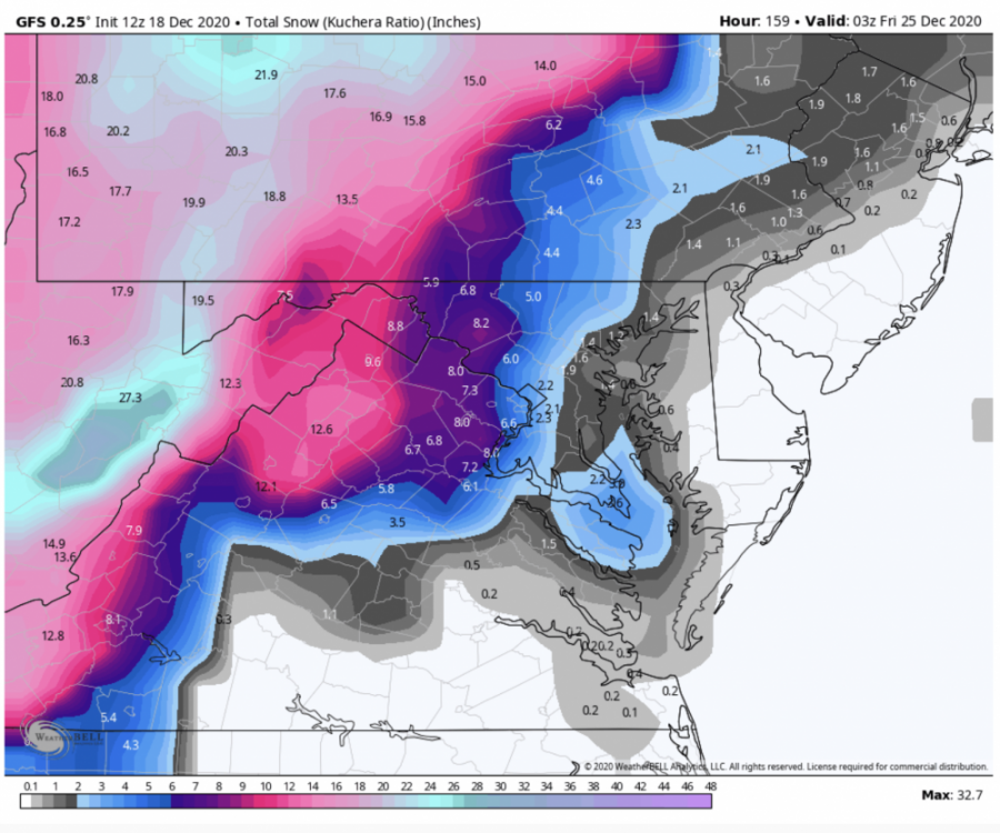
12z GFS doesn't look like it's going to make any friends in our section of the world, drives the primary into SWPA, so a lot of the front thump is sleet / zr / rain then the coastal doesn't throw much back to us.
As depicted it sucks but I think it is taking a step towards the euro has far as the coastal being tucked in. We need it to be wrong on the warmth it brings with the primary though for sure. It is the most bullish on precip for sure.

-
Euro hits us with the initial WAA and pulls the coastal low inland after transferring. Pretty much everything we needed to happen, now the question is how realistic would that be? Great overnight trends either way though.
-
 1
1
-
-
11 minutes ago, Rd9108 said:
yeah which could change. I think its safe to say that our ceiling for this storm would be 6-10. Let's just keep padding the total regardless.
I agree, nice to see everything coming on board for at least a few inches.
-
The Euro doesn't give us any front end love from the dying primary like the GFS and GGEM both do.
-
Much better than the 12z run yesterday at least our donut hole filled in with some dark blue.
-
GFS and GGEM both looking in the 4-8 inch range which you guys mentioned yesterday.
-
The EPS shows a decent number of moderate hits but the big potential does seem to be east of us by a good amount.
-

Primary weakens enough that very little precip makes it to us. Coastal gets cranking early this run but doesn't throw much snow back past south central PA. Looks like a huge hit for DC though on this run.
ETA: Actually looks like it crawls slowly up and off the coast so it appears DC-BOS get hit pretty good. Snow map won't be pretty on this for western PA
-
Quite the messy looking set up on the GFS. I am guessing we want the primary low to be limited in how far north it travels before transferring, while also rooting for the secondary development to be tucked. Probably a good reason miller B's don't often produce big totals here haha.
-
I will gladly trade the Monday storm for a better trend on Thursday’s storm. Thing looks like a beast
-
2
-
-
Next Monday into Tuesday starting to become interesting. Wouldn't mind taking my chances with a strong southern shortwave running into that block even if it does mean dealing with some mixing.
-
1
-
-
9 hours ago, RitualOfTheTrout said:
Light snow has been coming down for a couple hours, but to warm, nothing accumulating yet. Feels crazy to say that in mid January at night. Living in low elevation spot is brutal with marginal temperatures.
Looks like some slightly better returns on radar, might wake up to whitened landscape again.
During slower tracking periods I tend to read in the New England and Mid Atlantic forums for long range stuff. Figured I'd bring up one of the themes I keep seeing repeated by some of the knowledgeable guys in the MA forum to see if anyone has thoughts in here. It does feel slightly ironic bringing this up after one of our snowiest Decembers on record and a nice double digit snowfall we have all been craving.
The blocking regime that has evolved over January really has not resulted in much in the way of cold or snow which many have attributed to the putrid airmass that the block is currently holding in place. Basically a block does little good if there isn't already an established cold source nearby. Maybe I am not remembering correctly or mistaken because of lack of understanding but in the past I remember thicknesses that are well below 540 resulting in a colder reflection at the surface than what we are seeing this winter. Taking this past weekend as an example, I am surprised what evolved at the surface (mid 30's with snow in the air most of the time). I guess I'm curious if our cold fronts are going to continue to be moderated in the short term due to warmth in our cold source regions, or if this is something that is going to be a persistent issue moving forward?
Definitely not complaining with the winter we have had so far, just bored with a slow couple of tracking weeks and trying to better understand why the good pattern looks haven't lived up to the potential hype.
-
It is amazing how boring January has been for tracking snow. Looks like we might see some snow showers around Friday/Saturday but temperatures are looking marginal so I doubt much stickage.
-
Yea kinda funny that we finally get some blocking and there is no moisture anywhere to be found. But as others have stated we may be moving into a pattern where some northern stream threats pop up in the short range unexpectedly.
-
Merry Christmas everyone and good luck with the snow tonight! I’ll be in Johnstown for this and it looks like one of the few times where west is best.

-
3
-
-
Can’t wrap my head around how this would work out after the cold front moves through on Christmas Eve but oh how I pray lol
-
Just got back in from a 4 hour walk haha. One of the most satisfying storms I can recall with Christmas lights and off and on very heavy snow. Closing in on 10 inches here.
-
1
-
-
Radar looks good for some action later after this break.
-
Just got home from work and looks like the heavy band has already moved through, barely snowing at all in oakmont.
-
It has been pretty light for most of the day in Robinson. I'm anxiously waiting to get home as the heavier returns look to be setting up shop in eastern Allegheny and Westmoreland.
-
Snowed for about 30-40 minutes to drop a coating in Robinson TWP. Pretty much stopped now in a little bit of a lull.
-
Good luck everyone, regardless of outcome it was a fun storm to track. Time to radar watch and let the chips fall
-
2
-
-
43 minutes ago, KPITSnow said:
It was, yes. That was a whole different set of things that screwed us over on that one. We generally get screwed on these ones too....think January 2016 where you drove 50 miles south and east of Pittsburgh they had nearly 2 feet and I got 4 or 5 inches just north of the city.
It’s easy to be negative with our climo but honestly I feel like this storm is one of the perfect types to not give us a huge bust. No worries on mixing, not riding the northern edge and not waiting for a changeover. I think we’re in for a solid storm, doubt we jackpot but I don’t think we’ll be disappointed either. I think 6-12 is in play across Allegheny country.
-
4
-
-
I’m still liking where we sit with this one.
-
5
-

Western Pa / Pittsburgh area Winter Discussion ❄️☃️
in Upstate New York/Pennsylvania
Posted
Primary looks like it is dying in a good spot on the 12z Euro, this should be decent.