

Rockem_sockem_connection
-
Posts
451 -
Joined
-
Last visited
Content Type
Profiles
Blogs
Forums
American Weather
Media Demo
Store
Gallery
Posts posted by Rockem_sockem_connection
-
-
4 minutes ago, hazwoper said:
Yikes, 12-18" is possible but there's models showing as little as 7" down there. Sheeeeeesh
-
 1
1
-
-
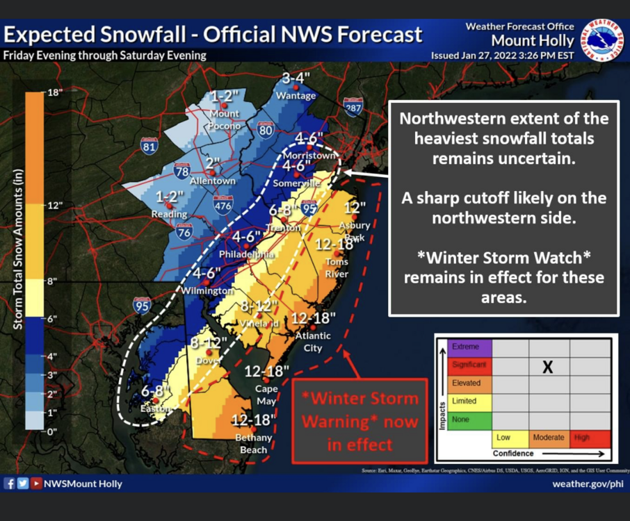
Seems like CBS3 is most aggressive with the totals showing 6-8" for PHL.No one else seems to be going past 2/4 3/6 I wonder what they are seeing that the other channels aren't.
-
1
-
-
58 minutes ago, Mshaffer526 said:
LOL at the GFS. We're back, baby!! All hail the king!
I mean it wasn't that much of a change. It's been closer all along than any other model *cough cough 2' snow on the NAM and EURO* lol. I'm not going to bat for the GFS but I adore her.
-
 1
1
-
1
-
-
4 minutes ago, mappy said:
in New Mexico?
You tell me I dunno. I stare at weather models and use past experience to guess like everyone else. All I see are chem trails on these things

-
 1
1
-
-
Looks vaporous I guess. Very cool
-
 5
5
-
-
1 hour ago, Ralph Wiggum said:
Still 6-7" here, so sign me up
Ain't you in PA Ralph? What the heck map are you looking at!! Must be a Kuchera guy
")
I seen what I need to see. 2-5" in PHL. 3-7" in SNJ. 4-9" down the shore. Locked and loaded folks.
-
1
-
1
-
1
-
-
Someone buy the GFS a beer. It's been virtually the same for days on end, it has to be right,
-
2
-
-
19 minutes ago, The Iceman said:
I think MECS/HECS is off the table, but the whiffs for 95 seem to be out of the picture for now too. Should be a solid 4-6" along 95 less west and more like 6-10" east. Not bad, should double snow totals in a lot of locations. Bummer though the Euro couldn't be once just this one time. What an awful model this winter.
Could be more like a 2-4"/4-8" which is the way I'm leaning currently. I don't envy anyone who has to produce maps for the public right now. Flakes literally start in 1 day and we're still not sure if this is absolutely nothing ALA GFS, something decent like the 12K NAM, or something in between like the Euro. Sheesh glad I bumped my flight up regardless, not worth this kinda stress.
-
1
-
-
Euro brings it a minor event to PHL. GFS is non event. NAM is decent event. The other assortment of store brand models have a bigger event. Good luck making a reasonable prediction out of that. 0-12" for PHL
-
1
-
1
-
-
Hard to say the GFS is right when it's basically alone but it's been consistent. So I guess 12z tomorrow we wait for more answers. Crazy crazy crazy
-
1
-
-
Just now, wasnow215 said:
I get it. But EURO and NAM solid now.
They haven't been completely consistent but the GFS has, that's my two cents. I think it's reasonable to expect/root for a 3-6" for alot of folks on here though but sometimes that's not enough when it was looking like it could of been way more, I dunno. Curious about the 0z GFS though makes it interesting
-
1
-
1
-
-
Just now, wasnow215 said:
Just popped in. Originally from SJ and live in Richmond, Va now. No one gonna mention 0Z NAM? Lol
Most people here live in Pennsylvania so wasn't all that great for them. Until the GFS shows something too it's useless getting worked up
-
1
-
-
1 minute ago, jayyy said:
It wasn’t what you said. It was how you said it friend.
I hold no grudges jayyy. I am sorry I could not word it like this fine poster did. The poster did a good job and is spot on.
-
4 minutes ago, psuhoffman said:
I didn't want to post this earlier when there was still a lot of hope and guidance was coming in but some thoughts I've had watching the "tracking" unfold for this event.
1) Know the bias of the guidance for the situation. The euro and NAM have a known bias to over amplify systems and phase too quickly in NS/SS phase situations. So seeing them as the only guidance the last 48 hours that was REALLY good...shouldn't have really excited much. If something is real it should show up on guidance other then the one that ALWAYS shows that because of a bias.
2) Don't fall prey to our own bias to look for positives and dismiss negatives. Example: if the NAM has a great run at 0z, then an awful one at 6z, then at 12z it trends better than 6z but not quite back to 0z...thats not a "good trend". That means the NAM is just bouncing around within a range of options and overall we are no better off then 12 hours ago.
Likewise for an entire suite of guidance. If the ICON was the furthest east and shifts west...that isn't a west trend. Its the ICON coming in line with consensus. If the euro was great and has a bad run...then the GFS trends better...we didnt actually gain any ground. Models are just shifting around within their envelope of likely outcomes. In the end of the suite we were still on the NW fringes of all possible outcomes in terms of significant snowfall. We needed the most extreme NW members of all model runs for each suite, including ensembles, to be correct to get a big snowstorm. Just because there would be one or two pieces of guidance that spit out that solution didnt ever make it the likely outcome.
3) There is no guarantee a "trend" will continue. I am NOT going to argue what a trend is. Call it what you want. I don't care. But when someone says "its still a miss but its heading the right way" I cringe inside. No its not. It's not heading anywhere. It's just one simulation based on the current data available. The next run could easily get worse. But if something got better some people seem to set the expectation that it will continue the same "trend" the following run. That sets us up for disappointment.
4) Inside 100 hours HUGE shifts in our favor become a lot less likely. Outside 100 hours we see major synoptic changes all the time. But once inside 100 hours the guidance has been really good, if you ignore a random fluke outliers and focus on the consensus each run, with the general setup. A lot of these situations lately we are taking very unfavorable synoptic setups inside 100 hours and trying to will the storm into what we want. I'm doing it too! But when we get these minor changes in a model that get it closer to a snowstorm for us...the odds are never that those improvements will continue run after run until its a snow for us. Odds are it was just a minor permutation and the next run is just as likely to shift back the other way because there is a reason its still a miss and is a miss on the preponderance of evidence...the synoptic setup likely isn't right in some way. I think the days of us saying "thats right where I want it" once its inside 100 hours are over. You know where I want it at 80 hours now....over us. This willing it north or south or west just fail's 90% of the time. The models have become a lot better. That doesn't mean we dont still see details ironed out. There will be changes to details. And sometimes...there can still be a true bust where some factor is not handled right and a storm shifts...but its going to be the vast minority of the time not the majority. We dont' want a storm 200 miles away in any direction inside 5 days out anymore. Truth is the storms end up pretty close to what the guidance shows once they start to converge on a general idea usually around 100 hours out lately most of the time.
5) big amped up phased storms are a lot of fun to track but not our best bet for snow in a progressive pattern. Boundary waves are the best bet to get snow here without blocking. Unfortunately we are getting a reminder in how frustrating a pacific driven cold pattern without Atlantic blocking can be. Truth is if we want a high probability of a big snowstorm we need BOTH. But we can definitely score waves moving west to east along a boundary in a gradient type pattern without blocking. Just need luck with wave spacing.
I said this yesterday, got grilled. Glad someone more articulate can make better sense than me. Thank you.
-
2
-
-
So, how about those trends Jayyy? lol classic
-
1
-
-
6 minutes ago, hazwoper said:
I’m sure Paul could update this thread with even more Miller Bs that have hit us hard.
I never said we don't get big Miller B's just that they tease us on models then many times have not panned out. The Philadelphia Inquirer apparently agrees with that so if you think that's wrong, I guess call them up and dispute it lol.
Regardless, we always understood there was a pattern towards the end of the month that showed potential. We got there, then never had model consensus. At least we understood that. These instaface weather folks cherry pick the craziest kuchera they can find, share it to tens or hundreds of thousands of people and get their hopes up, and then if it doesn't happen those people get upset and I feel bad for them. Those instaface cherry pickers are the great downfall to weather IMHO and I've had enough of them.
-
1
-
-
NAM looks poor. This one is about done I guess.
-
1
-
-
If you think Miller B's don't have high bust potential, that is on you. 2' storms are rare regardless. We did get a 2' Miller B in 2010 and 2016 so I guess we are due for a 6 year 2' Miller B but you're not getting it this time it appears.
Edit: Here's a fresh article I found lol
https://www.inquirer.com/weather/snow-forecast-philadelphia-weather-winter-storm-20220125.html
Sometimes that “B” can stand for bust around here as they often blow up too far north and-or east to affect Philadelphia.
-
1
-
-
5 minutes ago, hazwoper said:
And yet you had absolutely no sound scientific evidence to back up your argument. Congrats on your lucky guess.
TBF you don't need to be scientific to know that Miller B's set to dump 2' of snow in PHL usually don't work out. Probably 4 out of 5 times. So I mean, assuming the GFS was correct all along gives you an 80% chance of being correct probably.
-
2
-
-
GFS is king. It's been king for years. All hail the almighty GFS whether we like the outcome or not.
-
1
-
-
Yeah the GFS is most reliable and has been most consistent in recent years I find. At this point I'd expect the euro to show a 3-6" storm around Philly at 12z until it has not much going at all by 0z, and the GFS holds course. The Facebook weathermen will get grilled since they all shared the clown maps. They have done alot of harm to the public trust this winter, lots of unhappy people in their FB comments lol
-
1
-
 1
1
-
1
-
-
Miller B, the ultimate boom or bust situation. Good luck to the TV forecasters on this one
-
1
-
1
-
-
I had an opinion that no one liked. Is this where I am allowed to post now? Or do I just get banned soon? tyia
-
Sorry I'm not popular around here I'll go back to my hole. Good luck to tonight's observers. Many fine drinks in here, cheers. it's not goodbye just a see you later
-
2
-
1
-
1
-

January 28th/29th Event Obs - From KU to FU?
in Philadelphia Region
Posted
NAM brings some high totals into PHL. Will the GFS???????????