

Eskimo Joe
-
Posts
19,039 -
Joined
-
Last visited
Content Type
Profiles
Blogs
Forums
American Weather
Media Demo
Store
Gallery
Posts posted by Eskimo Joe
-
-
-
Guidance really dried up in the long range.
-
On 4/23/2024 at 7:04 AM, yoda said:
Mid 80s next Monday gets the hot designation in the zones? Because of near record high potential?
That's like a +15 departure 6 days out. Big heat signal.
-
 1
1
-
-
-
 7
7
-
1
-
-
38 minutes ago, aldie 22 said:
I feel like it needs to rain soon and pretty consistently....it's starting to get that feeling of a long hot dry summer and if we go into that dry then oh boy
The 2 inch and 5 inch soil moisture values on our mesonet sites are getting crispy.
-
1
-
-
I'm going to go out on a limb and say no late freeze this year.
-
2
-
-
On 4/8/2024 at 12:25 PM, Terpeast said:
Zero signs that the Japanese marine heat wave is ending. Looks like a carbon copy of 2022-23
Eternal pain.
-
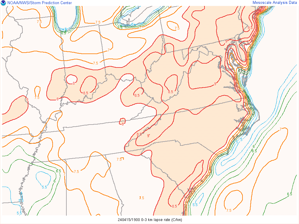
6 hours ago, 09-10 analogy said:
Pocket of 9 C/km LLLR SW of DC according to latest SPC mesoanalysis.
 6 hours ago, yoda said:
Don't see this either everyday in our region - 3pm mid-level lapse rates
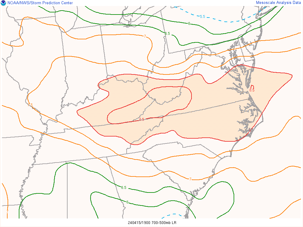
EML gives us wins.
-
1
-
-
M0.75" hail Gaithersburg
-
1 minute ago, ge0 said:
Berryville storm dumped a lot of hail
How large?
-
Looks like there maybe a subtle northwest moving boundary on LWX radar. Check out the 0.5° base velocity. If that can juice up those cells coming off WV then we might see some decent hailers coming into the NW suburbs.
-
1
-
1
-
-
Watch coming coming out. Looks like from I-70 south?
-
The terrain out west and the front in Pennsylvania are probably providing enough lift to get storms started. But it's clear they can't sustain themselves closer into the metro.
-
As we move into a more favorable time for severe weather, I'd like to pass along some personal and professional resources for severe weather that I have found useful over the years.
First, the professional resources:
- The Storm Prediction Center's (SPC) Rich Thompson gave a nine part series on tornado forecasting some years ago at the University of Oklahoma. It was recorded and uploaded on YouTube and has significantly expanded my knowledge of tornado forecasting and severe weather in general. Each video is about one hour long. Link: https://youtube.com/playlist?list=PLxeAIQgAiFqvsaAx79xN3gBjc8baIiWMn&si=O2fmocu33d95yGPd
- You will hear a lot about Elevated Mixing Layer (EML) over the coming months. There is a great research paper regarding the role of EMLs and northeast severe weather. While we are technically in the Mid Atlantic, the underlying fundamentals discussed in the paper are great for improving your knowledge. Link: https://journals.ametsoc.org/view/journals/wefo/25/4/2010waf2222363_1.xml
- Each year, there are questions about the SPC probabilistic outlooks. This link does a great job cross explaining the outlook and cross walking the percentages and the corresponding categories. Link: https://www.spc.noaa.gov/misc/SPC_probotlk_info.html
- Here is a great research paper focused on the SPCs probabilistic verification of their outlooks: https://journals.ametsoc.org/view/journals/wefo/33/1/waf-d-17-0104_1.xml
-
Some helpful links for real time observations:
- Delaware mesonet: https://www.deos.udel.edu/
- Maryland mesonet: https://mesonet.umd.edu/
- Keystone (Pennsylvania) mesonet: https://keystone-mesonet.org/
Second, some personal observations:
- There are numerous mesoscale boundaries across the area. They play a unique role in forming and disrupting convection and wreck havoc on forecasting.
-
The wedge always wins, until it doesn't.
- If we have a steady south-southwest wind, that seems to be better are eroding the wedge quicker.
- Getting a Day 2 Moderate Risk is a jinx.
- Events seem to set up further south at the last minute. See June 13, 2013. Day 1 Moderate Risk for DC that ended up in North Carolina.
- I have found that it is better to be level headed and expect a bust. There are so many small scale features that aren't resolved until 4 to 8 hours prior to the event.
- Downsloping kills events, but if you have either really cold temps aloft or better yet, a stout EML, then we can all win. Learn to look for these features.
- During large outbreaks, look to western North Carolina for what's coming our way. That's usually 4 to 6 hours from DC metro.
I hope this helps and good luck to everyone this year.
-
2
-
4
-
4 minutes ago, mdhokie said:
Groundhog day out in western md... Friends who live in Western PA say they've had real bad flooding.
RE: Western PA flooding yesterday
-
 1
1
-
-
50 minutes ago, North Balti Zen said:
Wind remains stupid.
I'm surprised there isn't more aggressive downsloping given the straight west component.
-
1
-
-
Tornado Warning for Norfolk. Their ASOS just gusted to 50 mph.
-
42 minutes ago, high risk said:
Hard not to be interested with a red box now up for areas just to the southwest, and the latest guidance showing a surge of instability ahead of the line segment. Overall, the CAMs show a weakening trend, and the hodographs aren't all that impressive, but I'll definitely be watching for a while longer.
Same. CIMMS I'm over in the obs thread for this event.
-
Tornado Watch for CHO metro until 1:00 am 4/13: https://www.spc.noaa.gov/products/watch/ww0107.html
-
M70 non thunderstorm gust at Wintergreen, VA.
-
1
-
-
Meso to our SW: https://www.spc.noaa.gov/products/md/md0426.html
-
6 minutes ago, pazzo83 said:
some nasty storms coming out of NC.
My rule for that is Mt. Airy North Carolina to DC metro in 4-5 hours.
-
Don't look no, but everyone west of I-81 was just put in a 5% tornado risk overnight.
-
April Discobs 2024
in Mid Atlantic
Posted
The soil moisture data at the Waldorf mesonet site perfectly illustrates this point.