raindancewx
Members-
Posts
3,920 -
Joined
-
Last visited
Content Type
Profiles
Blogs
Forums
American Weather
Media Demo
Store
Gallery
Everything posted by raindancewx
-
I only went back to 1931, but the years closest to ONI in JJA 2016 (-0.3), i.e. -0.2 to -0.4, are 1945, 1946, 1948, 1959, 1978, 1981, 1984, 1989, 1995, 1996, 2007, 2008, 2011, 2013. In the DJF season after the JJA season, those years averaged -0.42 for DJF, and the median is like -0.45. I'm expecting ONI in DJF to be between 0.0 and -1.0 - so for me I like weak La Nina years and cold Neutral years as analogs. Also think the peak (in La Nina territory) may come early, say SON, or OND, at -0.6 or -0.7 before fading to -0.3 or -0.4 for DJF.
-
Hurricane Newton is about to hit Mexico - should bring a lot of rain to Southern AZ/Southern NM and squash any attempt of the ridge of death from scouring out moisture after a relatively cold/wet August. September is wetter than the long-term average in La Nina years in Albuquerque, so will be curious to see if we knock out a quick inch from Newton. I'm a bit conflicted, last year we were having a bone-dry Aug/Sept and then a tropical depression saved September, and pushed the monsoon from "dry" to "wet". Completely screwed up my snow calculator in Albuquerque based on summer conditions - jumped from 10"-->15.7" once we topped 4.3" rain on Sept 22...and we got 10".
-
Weatherbell put up like five analog packages for the winter: DJF - consensus between D'aleo/Bastardi/Downs DJF - pioneer model (based on D'aleo correlating zones in the oceans w/ winter temps) DJF - "sensible analogs" combining a weak Modoki La Nina with a warm western Atlantic NDJ - analogs JFM - analogs The maps are interesting - they have a sharp split in NM, with the ~NE 1/4 of NM snowier than normal, but the SW 1/2 of NM less snowy than normal. I would say I'm right on the edge of being "normal" and "below normal". That does seem about right, most of the objective comparisons I come up with have ~7-9" for Albuquerque, against a long-term normal of 9.6". 7-9" is actually above average for a La Nina though. The maps have North Texas and most of Oklahoma doing well for snow. The pioneer model does match SW precipitation patterns pretty well this monsoon, even though it is too cool for July / too warm for Aug against what we observed, but seems like the best match for winter. Seems like it's a slightly warm winter in NM - but the warmth (+3 to +5F) is centered near the NV/ID border. New Mexico is more like +0 to +2F.
-
Have to keep our eyes on the tropics nowadays - the system moving into the Gulf of Mexico could still veer west to LA/TX. Looks like August 2016 is going to be just about the same temperature as September 2015 - which means it's a pretty cold month. We're at 86.2F through 28 days for the mean high, tied with September 2015 - with three more days for the mean high to drop slightly. Mean low is still a touch warmer than Sept 2015 here, but will likely end up very close to Sept 15 too. I figure w/ the Aug mean high colder than Sept 15, and the mean low warmer than Sept 15, the mean temperature for Aug 16 should just about equal Sept 15.
-
Central/Western Medium-Long Range Discussion
raindancewx replied to andyhb's topic in Central/Western States
I was running some figures for the SW, and it seems like in most locations, September is always colder than August in terms of mean highs. That favors September being either near average or cold out here. From 1931-2015, every September in Albuquerque was 1F to 12F colder than August. "Cold" Augusts in La Nina and Neutral years seem to drop off by ~1-8F over the past 85 years. If you blend it all together, the best bet would be a drop of 5F, with September ending up ~1.5F below normal, after August ends up ~2.5 to ~3.5 below normal. The years I'm looking at are 1933, 1935, 1961, 1967, 1971, 1974, 1988, 1989, 1990, 1999 for August in the SW. My somewhat rigorous odds imply ~5% chance of a warm September in the SW (>=+2F v. mean highs) and maybe a 55% chance of near normal (+/-2F) and a ~40% chance of cooler than normal (-2F or less v. mean highs). -
Another blazing hot day here in the Southwest, almost got 80F today in Albuquerque. Mean high in August is now down to 86.8F for Albuquerque - huge drop of 8.6F from mean highs in July to mean highs in August so far. From 1892-1930, the biggest drop off in Albuquerque was 7.4F, and from 1931-2015, the biggest drop off was 7.6F. So will be interesting to see how low we will go. Will probably fall back into the mid-50s tonight, assuring tomorrow is fairly cool too.
-
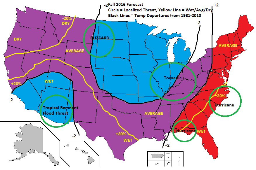
Any of you have thoughts on a Fall (Sept-Nov) forecast? I don't have a method for analogue-ing Fall, so this is just my guess. I think the rex-block in the Pacific that has had the NW hot lately is semi-permanent for about half the fall, but will get moved by Pacific typhoons eventually. I have AZ and the MW cool, due to monsoonal moisture (it's been quite strong in much of AZ), and I have the +PDO sending cool shots down the middle of the US throughout the Fall. Also think that with cool water off California surrounded by warm water, that storms may intensify to some degree as they come to California, and so Southern California may get a fair amount of rain this fall, particularly after Nov 1. In the East, I buy into the warm AMO/western Atlantic keeping the warmth in place to mid-October. For New Mexico, I think the wet signal (+PDO) is strong enough to overcome the weak dry signal (weak La Nina at best), especially as the +AMO gets drained of it's influence to some extent by hurricanes cooling the ocean. I try to put in precip/temp anamoly lines so people can see if they are say, hot/wet v. cold/wet too.
-
Bastardi (this has been posted publicly, so it's OK to share it), had three main analogs for Winter 16-17: 58-59 59-60 93-94 If you map those years the SSTA are damned close to now. But he thought the Atlantic was too cold in those years, so he throws in 2011-12, 2013-14, and 1995-96. He is going to update the winter forecast by the end of this month though. With the weighting he had this: 1958-59 x2 1959-60 x2 1993-94 x2 2011-12 2013-14 1995-96 This winter is a bit tricky, probably need years with the PDO Neutral and Positive, AMO Neutral and Positive, and ENSO Neutral and Negative to come up with a useful holistic match. I lean towards a cold fall and a slightly cooler than normal winter for the SW at the moment.
-
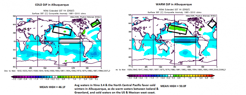
PDO just came in for July 2016 - down to 1.25 from JISAO. Well below last July. Suspect August will be down again too, given that there is cold water off the US West Coast. I was mapping my coldest winters (ABQ) and warmest winters by SSTA (1981-2010 base) today, and it looks OK for winter, two of the four regions support cold winters right now. Warmth between Iceland/Greenland shows up as an Ocean feature in cold Dec-Feb winters, we have that now. Cold waters on the West Coast support a cold winter too. Borderline La Nina is bad, as is the warmth in the North Central Pacific, but all in all, not terrible looking right now. The cooler West Coast waters and strong monsoon in AZ make me think at least parts of the SW will have a wet winter too. The drop off in July-Aug temps has been fairly massive too which helps.
-
AMO value for July is in: 0.445. Highest in any month since Sept 2012. NOAA had the July PDO value at 0.18, way down from last July. PDO signature to me actually looks slightly negative of neutral right now, with a cold ring of waters surrounding a warm tongue. https://www.ncdc.noaa.gov/teleconnections/pdo/ It's not great to have a -PDO, La Nina, and AMO+ for the SW, in fact it's probably our worst possible pattern, so I'm hoping the hurricane season ramps up quickly, cools the Atlantic with upwelling, and then the PDO only falls to neutral for (+/-0.5) for Nov-Apr and that we end up in a weak La Nina Modoki or a cold-Neutral. It has been wet here in August, which is usually a good sign even in La Nina cold seasons. March precip is strongly tied to August & October precip regardless of ENSO state.
-
If you go to Weather Trends 360 and play with the maps, the Northern/Western Atlantic is much warmer, the eastern Atlantic is colder, the tropical Pacific and Eastern Pacific (although not he Gulf of Alaska) is also a lot colder. For some reason the Gulf of California the waters off Central Mexico are warmer. So I'm thinking the interior SW (NM/AZ) may actually have a colder (Pacific is colder) but still wet winter (since Gulf of California is still warm)
-
One big thing to watch in the coming weeks is whether the monsoon returns with a vengeance to NM/CO/West TX. July before Neutral winter is often (47% of the time) pretty dry (<=1" rain in Albuquerque), but July before a La Nina is pretty rarely dry (<=1" rain in ABQ just 19% of the time). The difference is statistically significant in terms of rejecting the idea that the frequency of dry Julys is the same before La Nina and Neutral - it isn't true - Neutral is drier in July. In the Neutral years with a dry July, the monsoon almost always returns with ferocity in August, while in La Nina...it doesn't. I lean towards the winter being a Neutral now, so we'll have to see what August does, but my hunch is the monsoon comes back pretty strongly.
-
Central/Western Medium-Long Range Discussion
raindancewx replied to andyhb's topic in Central/Western States
The AMO (ESRL/Kaplan) came in at 0.423 for June 2016 - highest June value since 2010. Likely high enough to all but assure it remains positive in the cold season. Not many winters with a PDO+, AMO+, cold Neutral to strong La Nina. -
Central/Western Medium-Long Range Discussion
raindancewx replied to andyhb's topic in Central/Western States
Weathertrends 360 has the core of summer hot/dry for most of the USA. -
Central/Western Medium-Long Range Discussion
raindancewx replied to andyhb's topic in Central/Western States
The 24th-26th looks interesting. Larry Cosgrove seems to think this setup of "cool west" "warm east" remains until maybe mid-May. -
Central/Western Medium-Long Range Discussion
raindancewx replied to andyhb's topic in Central/Western States
That's a stupidly powerful system - will be interesting to see if the Euro is right or if it goes North like the GFS says. -
Central/Western Medium-Long Range Discussion
raindancewx replied to andyhb's topic in Central/Western States
I'm going to put this here - we can see how well it verifies. -
Central/Western Medium-Long Range Discussion
raindancewx replied to andyhb's topic in Central/Western States
There are bowling ball lows...and then are bowling ball lows. Crazy - -
Central/Western Medium-Long Range Discussion
raindancewx replied to andyhb's topic in Central/Western States
This still looks on track, assuming the March pattern comes in as advertised after March 7th. -
Central/Western Medium-Long Range Discussion
raindancewx replied to andyhb's topic in Central/Western States
Accuweather seems to like Spring 1983, 1987, 1998, 2007 for analog years based on this: http://www.accuweather.com/en/weather-video/video-traditional-and-hybrid-el-nino-patterns-used-through-spring/97649985001 2007 x2 1987 x2 1983 x2 1998 x1


.thumb.png.e3433253da191657f57f7513e7ddd069.png)