
hardypalmguy
-
Posts
1,030 -
Joined
-
Last visited
Content Type
Profiles
Blogs
Forums
American Weather
Media Demo
Store
Gallery
Posts posted by hardypalmguy
-
-
1 hour ago, CheeselandSkies said:
12Z NAM has 42 degrees for MBY at 21Z tomorrow, and 58 in Galesburg, IL about 2.5 degrees latitude south. Brutal.


Lake Michigan will keep MKE in the 40s for highs well into June.
-
54 minutes ago, Hoosier said:
So you're telling me the US might be warmer than average this summer?

Probably not. The trough of blue will slowly appear in between those obvious ridges and the midwest/lakes will have a cold and wet summer. Lots of northwest flow and cut off lows.
-
 2
2
-
 2
2
-
-
GFS and Euro are back on board with a brief zonal severe threat around the 30th, sandwiched between typical trough patterns. Now that I mention it again it will probably be taken away again. Sad that is the only possible interesting thing to look forward too. This current warmup looks like a complete dud as far as any storms in my area. ZZZZZZZ......
May looks cold too. Typical last several years.
.-
1
-
-
Windy and raw day. Barely 40. With lots of rain. Tomorrow should be low 80s. Can’t wait. Next week turd weather comes back.
. -
69 here today, 72 at MLI, 69 or 70 at DVN depending how it rounds. Felt fantastic after the previous 7 days.
MKE kissed 70.
. -
MKE hit 70 today. Overachieving!
.-
 1
1
-
-
The midwest/lakes has largely been in cool anomalies while the rest of the world ratcheted up in warmth in recent years. Once the "false bubble" of cool anomalies move out of this area, the warmth is going to be unmistakable.
-
11 hours ago, frostfern said:
I'm going with the Euro, but we'll see. GFS is often too flat. Early May doesn't look good on any of the ensembles, but there might be one warm day towards the end of April before Hudson Bay high wins out.
No spring again this year. When it flips to summer, we are going straight to 80s and the green up will be overnight again. Lately fall does the same thing. Winter switch flips and we go from sustained 70s/80s to 40s.
-
1
-
1
-
-
If we can realize some good sun on Saturday, MKE is going to blow past 80.
-
13 hours ago, Baum said:
buckle up Dead Palm Guy.
With climate change we are 100 years away from sustained palm trees up here.
-
 1
1
-
-
33 minutes ago, IWXwx said:
And it's no better to your south. IND posted this little tidbit on their FB page:
"It's been a cool stretch into April so far with no 70° days. Last time this happened was 1990 when the first 70° day didn't happen until the 22nd."
Look what happened on May 10, 1990 in Wisconsin. We do not need a repeat of that.
-
Holy hell is that 2 back to back snowstorms for southern WI?
-
I can't take this weather anymore. Looks like one warm day Saturday then back to turdfest.
-
1
-
2
-
-
Let’s get a Morch 2012 redux going.
.-
 2
2
-
1
-
-
Late February torch looks likely.
-
1
-
1
-
-
1 hour ago, Hoosier said:
Here it is... tornado confirmed in MN for the first time in December. Also an EF2 in WI.
Public Information Statement
National Weather Service La Crosse WI
1124 AM CST Thu Dec 16 2021

...Preliminary Tornado Information From December 15th...

NWS La Crosse storm survey teams have confirmed two tornadoes so
far from the December 15th severe weather event.

An EF0 tornado occurred east/southeast of Lewiston Minnesota in
Winona County.

An EF2 tornado occurred north of Neillsville Wisconsin in Clark
County.

Complete damage survey results on these tornadoes will be released
later today.

$$

04
Stanley, WI has been obliterated.
-
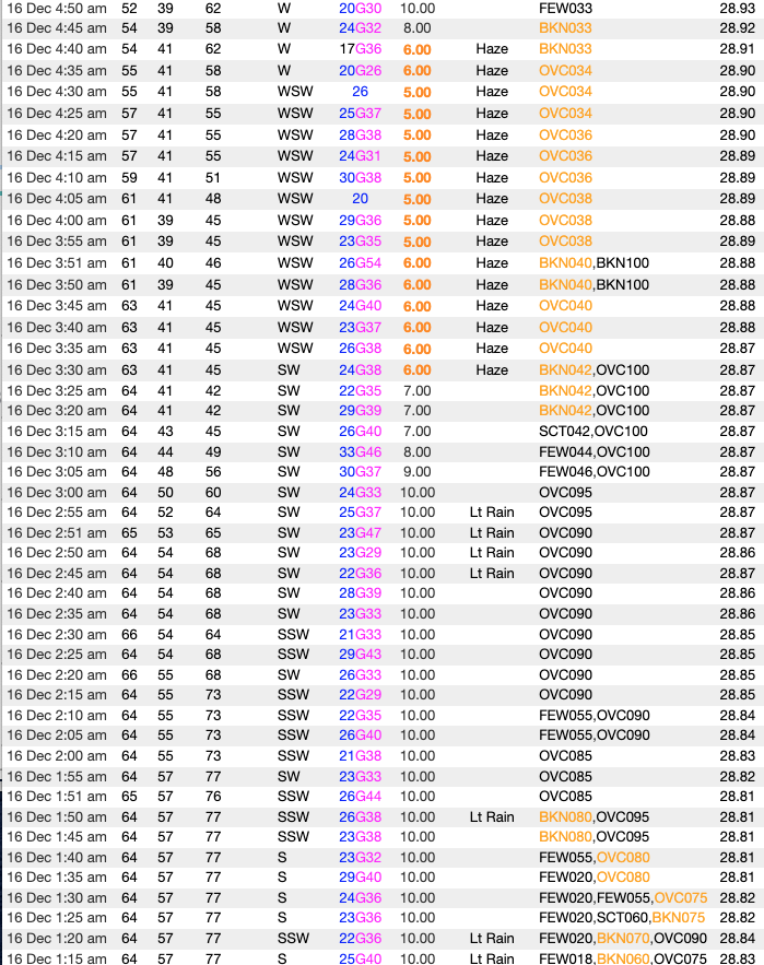
4 hours ago, purduewx80 said:
Pretty interesting evolution locally last night. In the GeoColor CIRA image below, there is some dust and/or smoke evident over the Great Lakes, which no doubt came from the Plains late yesterday. All the local obs dropped below 6SM in HZ as dry air surged in (subsidence? dry line?) behind the remnant showers. Note the pressure rises, drop in dews and slow temperature fall at ORD.
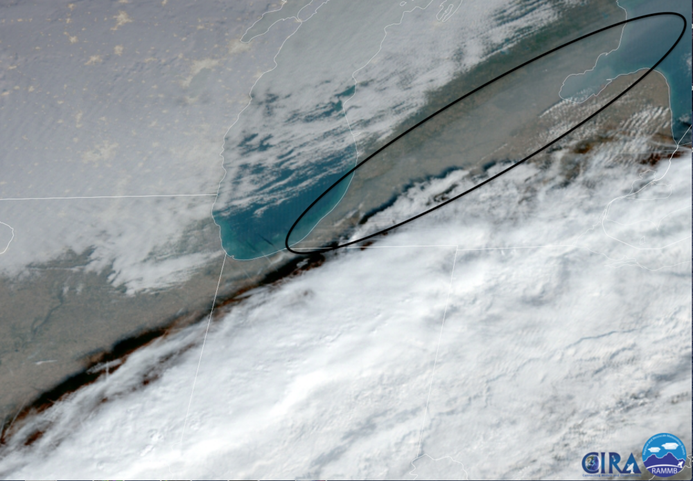
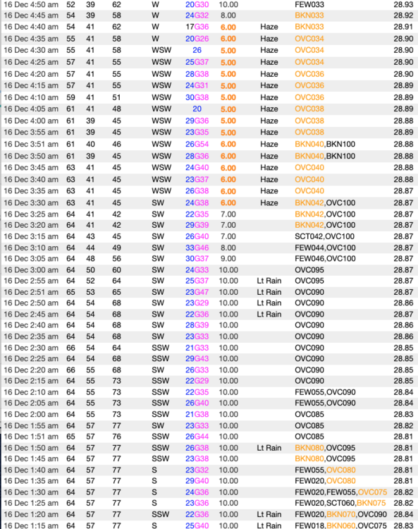
Wow for us to get a dry line, let alone in December is nuts.
-
9 hours ago, Geoboy645 said:
I figured that their should be a thread for this storm at this point with the wind threat and unusual warmth. The models are really starting to hone in on a major wind event tomorrow night for most of the region. Some runs like the 0z GFS even have 70-75mph gusts for multiple locations, especially in Iowa, Northern Illinois and Wisconsin. This could be the largest non-Tstorm wind threat in at least 5 years if not since the Chiclone of 2010 for some areas. I'm increasingly worried about power outages, as our grid is not really used to such sustained heavy winds. Add in the incredibly unusual warmth for this time of year (Madison looks to break their monthly record) and the Iowa severe threat, this is shaping up to be quite the storm for the area despite the lack of wintry weather.

Looks beautiful. Warm weather and hurricane winds. All we need is some palm trees to take some awesome video.
-
1
-
1
-
-
15 hours ago, Stebo said:
Of course that is a troll post, from a troll who has been banned multiple times but keeps coming back like bad penny.
Board is losing members since message boards are going the way of the fax machine. Can't afford to ban people who want to discuss the weather.
")
-
15 hours ago, OrdIowPitMsp said:
That sounds like absolute hell. Troll post?
Sounds like absolute heaven. Everyone has a weather preference.
-
Nothing is better than endless torch in winter. I'll take 50s and 60s all winter and 80s and 90s all summer.
-
1
-
-
Torch time incoming. The best weather.
-
2 hours ago, CheeselandSkies said:
Honestly not looking like a great chase day. Central/northern WI where the chance for discrete supercells is highest is terrible terrain/trees. Of course I will keep tabs on things but the threat doesn't look to get further south until late when it'll be dark and derecho mode in full effect.
Leaving from just north of Milwaukee around 3:45 PM, where would you go? I'm itching to get out.
-
1
-
-
40s during mid day? LOL GFS is on drugs.

Spring/Summer 2022 Complaint/Banter Hangout
in Lakes/Ohio Valley
Posted
Try coming north to Wisconsin and watch the warm front stall at the WI/IL border several times each spring.