

hardypalmguy
-
Posts
1,030 -
Joined
-
Last visited
Content Type
Profiles
Blogs
Forums
American Weather
Media Demo
Store
Gallery
Posts posted by hardypalmguy
-
-
37 minutes ago, Cary67 said:
Euro and CMC dangle carrot post Valentines

Now do GFS.
-
 1
1
-
-
Also spring and fall snowfall has taken a nose dive (down 50%!) and is what you would expect to crash first in a warming climate -- since temperatures are much more marginal in those time periods.
.thumb.png.27a728655a683af833fe31a8aaf6eb61.png)
.thumb.png.05e7f8bf8b62d3aa5180f61f96acf6c9.png)
-
2
-
-
34 minutes ago, michsnowfreak said:
You play the trolling game well, I won't step on your toes for that. But be prepared to always be called out with stats. "Once we reach the cliff edge where most storms change from snow to rain", LMAO that's not even how weather works.


Dawg, at least you could try and not clutter data with noise from the 1800s. Things become much more clear when you do 50 years of data. Rapid warming. 21.6F to 28F. Yikes.
.thumb.png.9e12bf1d5d4b9a5bc8c53c4b2f2ae00a.png)
-
3
-
-
1 hour ago, michsnowfreak said:
Bruh this is 3 days after the image he posted, on the same model. It's a short lived cold shot but my point is this guys literally picking a random image at 150 hours and saying Winter is over. Although, I looked him up, he's in Boston. With the southeast ridge battling increasing cold in Canada, Boston will likely have less cold than Milwaukee.

I'm popping popcorn -- you hungry?

-
3
-
-
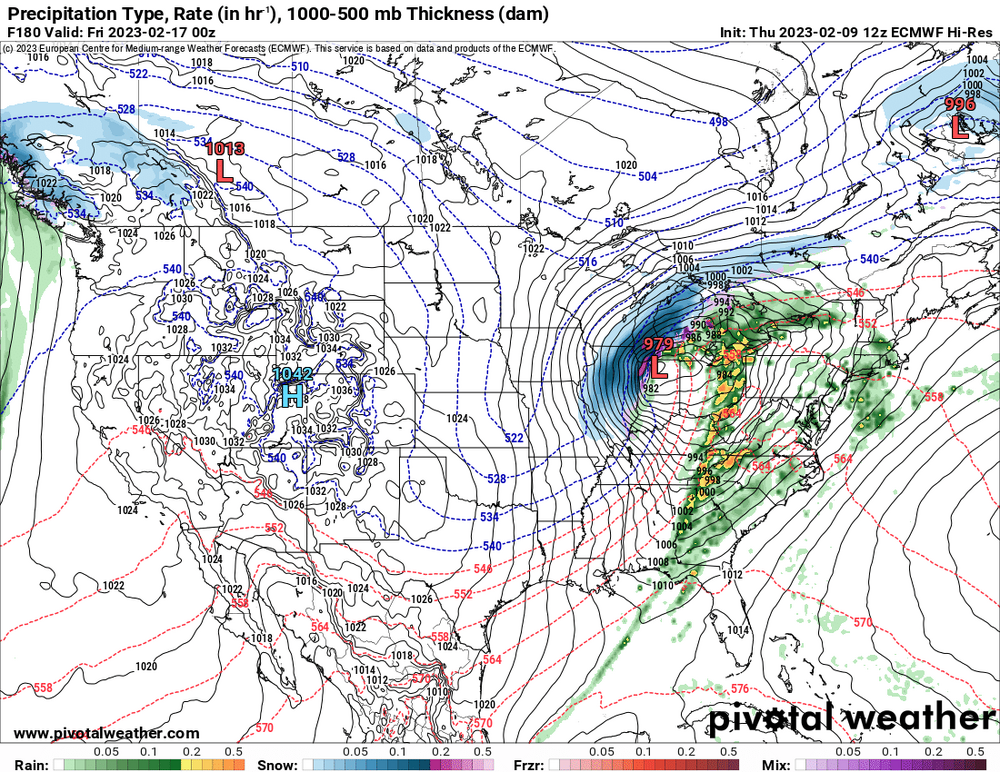
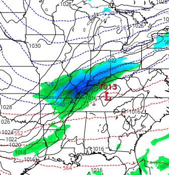
1 hour ago, buckeye said:
This is an example from the 12z gfs. It seems with storms this winter, the cold sector precip shield almost always has rain outside the heaviest precip band, (even on the nw flanks). I don't recall seeing this in past winters on models, at least no where near as prevalent.
I like seeing that. I've been watching average temperatures climb since I've been a kid. And we are close to reaching that tipping point where most systems flip from snow to rain. We are right on the cusp.
-
3
-
-
26 minutes ago, michsnowfreak said:
Considering snowfall averages are at all times highs for many areas, they very well may start to go down a little bit.
They are higher now because as average temperatures warm, initially they go up because warmer temperatures allow the atmosphere to hold more moisture. Once we reach the cliff edge though where most storms change from snow to rain, they will fall fast and hard.
-
 1
1
-
2
-
-
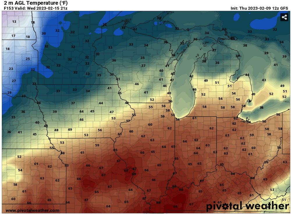
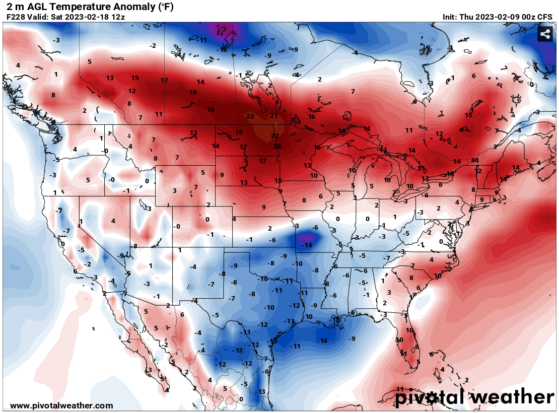
Get the baby powder and sunscreen out. Gonna be roasting next week.
-
2
-
2
-
 2
2
-
-
9 minutes ago, A-L-E-K said:
he's not wrong, ready for our new lake modulated stl climo
First freeze avg Thanksgiving and last freeze avg St. Patricks day coming soon.
-
4
-
-
11 hours ago, DaveNay said:
It all averages out to...average. It kinda has to.
Averages will start going down with each new dataset.
-
1
-
-
11 hours ago, michsnowfreak said:
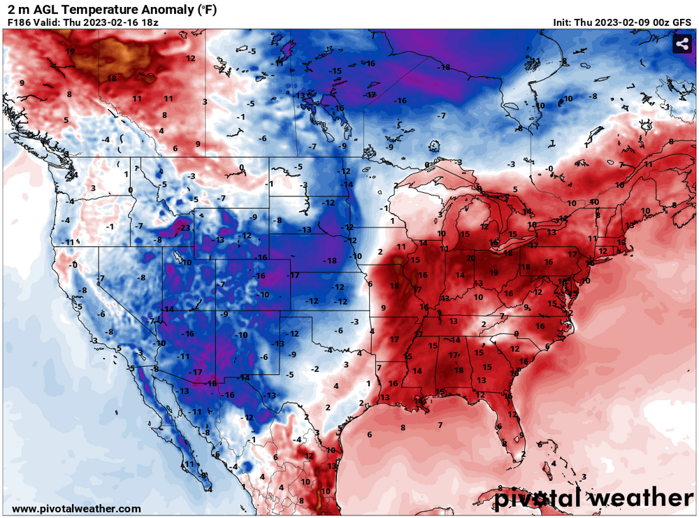
It's been forecast to be warm in mid February for weeks now. So this dude just randomly picks a screenshot and acts surprised by it? What's funny is 2 days later it's cold
Bruh, no it's not. Looks pretty roasty eastern CONUS.
-
1
-
1
-
-
8 hours ago, frostfern said:
I get the same way here in the summer when the thunderstorm shield happens and the flowers die and the vegetation starts getting brown.
I actually don't mind droughts as long as it's hot in summer. My garden hose keeps my tropicals happy.
-
1
-
-
11 hours ago, beavis1729 said:
Touche, and fair enough - I probably picked a bad example.

But it sucks when it's sunny and in the 40s in Feb. Why is that controversial? And, either way, who cares how MSP is doing vs. their climo; it only matters how they're doing in an absolute sense vs. what winter should be like. Miami had a great winter vs. climo in 1976-77, with all of the oranges destroyed and temps in the 20s with snow flurries on one day. Does that mean they had a good winter? Of course not.
And, please everyone - don't put words in my mouth. I've never demanded Siberia or interior Alaska, or even the Keewenaw. It's very simple - on Feb 8th, it should be cold with snow cover and frozen lakes. End of story. Is that really a "next level" request? Are we not allowed to want it to be winter in DJF? I'm tired of having to depend on events, as opposed to being able to rely on the calendar. Sure, good winters can have more events than bad winters...but all that really means is there's either 20" of snow cover and 20" ice depth on Feb 8th in a good winter, vs. 6"/6" in a bad winter. The season looks like the season should, no matter what the winter-to-winter variability is.
It's exhausting to accept everyone's low standards...like we're psychologically convincing ourselves that everything is ok, when it's not. It's easy to be content when standards are low - a good metaphor for life.
Look at the F-6 for Minocqua this winter so far. 46N in the great state of Wisconsin. It's been a sub-par winter for their standards...and it's a neighboring state, and not very far away...yet it has looked and felt like winter since 12/1. Most days have highs 15-35 and lows -5 to 15. Nothing crazy - just consistent winter. And, again, this is a bad winter for them! A bad winter vs. climo there is a great winter vs. climo here - it sucks.
My standards for summer are 85-95 every day and dewpoints around 70. But every summer, a cold front comes through (even in July) and I get to suffer through days in the 60s with a dry NE wind off the lake. So I guess my standards for summer are like yours for winter in reverse?
Oh and climo says I should be in the 80s all of July. 60s should never happen, right?
-
1
-
-
I think what's making it worse is this is the 2nd one in a row well below average for snow. It'll all even out in the seasons to come but stacking two crappers back to back definitely sucks lol.
You sure about that? Climate change says this is the new normal. There might be blips here and there but winters like this (and even warmer) are here to stay.-
1
-
2
-
-
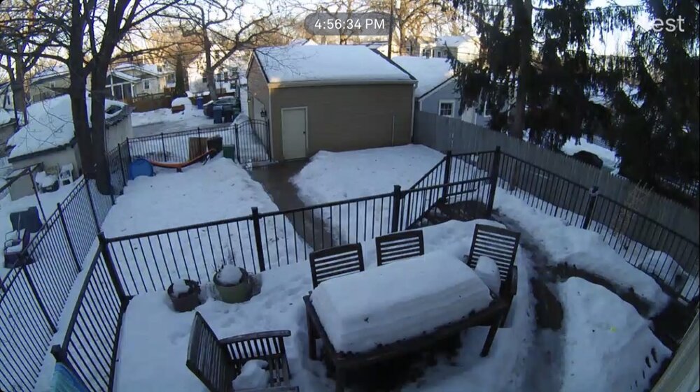
We’re fine. A midwinter thaw is totally normal. I’ll be jonesing for fresh snowfall now that the pack has a dirty look to it. Kinda cool with the melting you can clearly see the multiple layers on our table. Extended doesn’t look great but there’s still plenty of time left up here.
MSP is warmer than MKE by April.-
1
-
-
What I said.

-
1
-
3
-
-
33 minutes ago, beavis1729 said:
That sucks...even our friends at 45N can't escape the misery of this winter.
Hopefully you can retain a decent snow cover.
This winter is gold.
-
1
-
-
30 minutes ago, madwx said:
up to the upper 40s. Looking like we'll do this again early next week
Winter is over. Rocking mid March 45 days early.
-
1
-
-
1 hour ago, michsnowfreak said:
Exactly. I always look at the one on weatherbell. The only thing worth looking at on the actual CFS site is to see if today's graphic will be used as troll material for Cromartie.
Hey man, 2 weeks of winter so far. I'm still waiting since Christmas for it to come back and stay like you said it would...ride the torch has verified more this winter than "pattern change to cold".
")
Let's revisit this in early March (Morch) when grass is greening up and birds are singing.
-
1
-
-
30 minutes ago, Cary67 said:
^Winter won't be the problem. The problem will be when that same six day forecast verifies for the middle of April.
We've done that since 2018. We are due for a warm April.
-
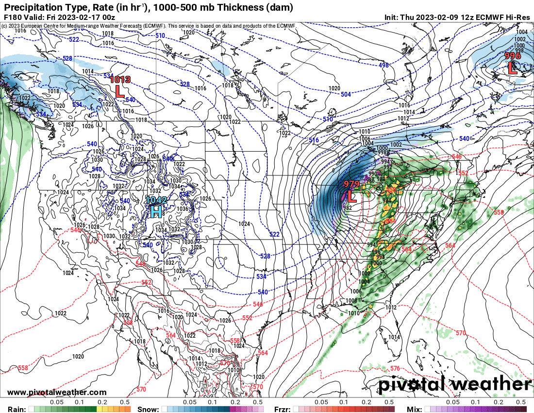
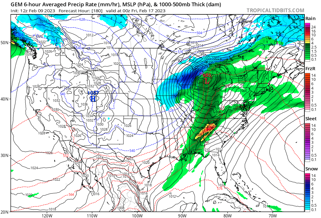
Apparently no one's noticed because all anyone cares about is snow, but there's a marginal risk almost up to I-80 in IL today and another one tomorrow for most of IN/OH/far eastern IL and far S Lower MI. 5% wind contour both days.
Let’s go!!! I wanna see another 8/18/05. That was wild.-
2
-
-
CFS must not be seeing the PV breakdown.
Or it sees it spilling into Siberia.-
2
-
-
Uh oh… SE ridge becomes CONUS ridge. Morch….is that you?!?!

-
1
-
-
Looking at the upcoming pattern, given the MJO influence likely playing a role in flexing the SE ridge, certainly not a cold look and some outright torch days will be in play. That said, the fact that there will be cold air into Canada, northern Plains, northern Lakes, means it's not a pattern not necessarily devoid of snow threats farther south (still would be better farther west you go given the southeast ridge).
While the favored corridor overall should be similar to what we've seen this winter, shorter wavelengths this time of year with an already active wave train is how it can work. There have been some operational runs showing this, with a lead warmer cutter and then follow up wave interacting with a temporarily shunted baroclinic zone post fro-pa. It's thread the needle amidst more wet than white threats, but not zero (though pessimism is not unreasonable).
After the mild and wet southeast ridge regime, still looking at a possible transition to a better pattern beyond mid month with positive height anomalies in the western part of the EPO domain and potentially -WPO as well forcing the TPV a bit farther south. This may be related to MJO wave propagation and stratospheric evolution. In the last few runs, the EPS has been a bit quicker to go into a colder look, so certainly not a lock yet.
Sent from my SM-G998U using Tapatalk
Never was a fan of a secondary low riding up the cold front. If the main show doesn’t produce, it’s usually a letdown.-
1
-
-
Gonna go out on a limb here and say the roof was closed during those games, and it was 68 degrees inside the stadium.
Palm tree weather and green grass inside.-
2
-
.png.6c477976f1b4bfabea89813088374985.png)
.png.55db1ebdee21cf872591fb2d3e8430ad.png)

.png.e0cbb167aab40a2e7c8b687d0b271a1c.png)


Winter 2022/23 Banter Hangout
in Lakes/Ohio Valley
Posted
1880s, 1930s and part of 1950s skew data warm as he used. This new pattern is the development of the world within the last 50 years so 1970s makes sense.