
hardypalmguy
-
Posts
1,030 -
Joined
-
Last visited
Content Type
Profiles
Blogs
Forums
American Weather
Media Demo
Store
Gallery
Posts posted by hardypalmguy
-
-
TSRA going on. Spring is here.
-
 1
1
-
-
A map that only the Minnesota posters and palm dude can love.
EDIT: What the heck is going on in CLE?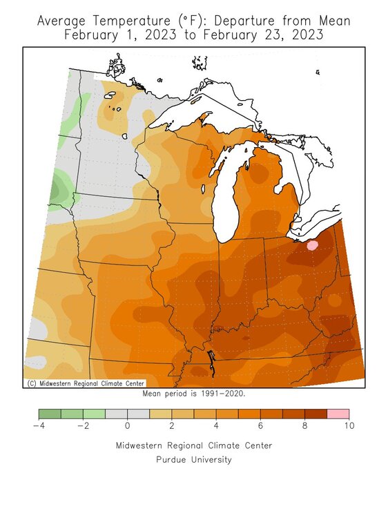
Not warm enough.
.-
2
-
-
1 hour ago, Hoosier said:
So you want snow, beavis? Just head to the Los Angeles metro area.
Seriously though, I wonder how often something like this happens out there. Especially the blizzard warning. Not familiar with that area at all.
URGENT - WINTER WEATHER MESSAGE
National Weather Service Los Angeles/Oxnard CA
340 AM PST Thu Feb 23 2023

CAZ053-054-232100-
/O.CON.KLOX.WS.W.0002.000000T0000Z-230224T1200Z/
/O.CON.KLOX.BZ.W.0001.230224T1200Z-230226T0000Z/
Ventura County Mountains-Los Angeles County Mountains-
Including the cities of Lockwood Valley, Mount Pinos, Acton,
and Mount Wilson
340 AM PST Thu Feb 23 2023

...WINTER STORM WARNING REMAINS IN EFFECT UNTIL 4 AM PST FRIDAY...
...BLIZZARD WARNING REMAINS IN EFFECT FROM 4 AM FRIDAY TO 4 PM
PST SATURDAY...

* WHAT...Winter Storm Warning through late Thursday with low
  elevation snow, strong winds and very cold wind chills. For the
  Blizzard Warning, heavy snow, winds gusting up to 80 mph, and
  near zero visibility. Total snow accumulations from 6 to 12
  inches likely between 2000-4000 feet up to 2 and 5 feet of above
  4000 feet. Isolated amounts to between 7 and 8 feet at higher
  elevations. Major mountains passes will be affected by
  significant snowfall.

* WHERE...Ventura County Mountains and Los Angeles County
  Mountains.

* WHEN...For the Winter Storm Warning, until 4 AM PST Friday.
  For the Blizzard Warning, from 4 AM Friday to 4 PM PST
  Saturday.

* IMPACTS...Travel could be very difficult to impossible. Very
  strong winds could cause extensive tree damage.

PRECAUTIONARY/PREPAREDNESS ACTIONS...

If you must travel, keep an extra flashlight, food, and water in
your vehicle in case of an emergency.

Travel should be restricted to emergencies only. If you must
travel, have a winter survival kit with you. If you get stranded,
stay with your vehicle.

The latest road conditions from CalTrans are available by calling
1 800 4 2 7 7 6 2 3.
How long of a drive from LA downtown is this?
-
11 hours ago, Hoosier said:
Alluded to this in the storm thread, but figured I'd bring it over here for more detail.
While the storm of 2/22/2023 will largely be forgettable for Chicago, this calendar day managed to pull off a combination that is quite uncommon.
1) have a high in the 30s
2) have 1"+ of precip
3) have less than 1" of snow
The above combination has now happened only 14 times since 1884-85 (the first year that snow records are available), so it's about a 1 in 10 year occurrence over the long haul.
For some comparison to a different season, Chicago has officially hit 100 or higher a total of 65 times. That is over 4 times as much as what occurred today. Of course it's not exactly apples to apples -- you either hit 100 or you don't, and that's that -- while this requires all 3 conditions of highs in the 30s, 1" precip, less than 1" of snow to be met. But you get the idea.
Here is the list of all calendar days with highs in the 30s, 1"+ precip, and less than 1" of snow in Chicago. All of these would've largely been a cold rain or some combination of rain and freezing rain. Snow amounts for each date are listed last. Everything else is self explanatory.
11/10/1898: 36/33, 1.20", 0
4/16/1921: 36/31, 1.97", 0.1"
11/29/1930: 38/18, 1.19", 0.1"
3/12/1939: 35/31, 1.10", T
2/6/1942: 35/35, 1.98", T
4/19/1947: 39/36, 1.40", 0
1/18/1949: 35/17, 1.11", 0.2"
3/26/1959: 39/35, 1.40", 0
12/11/1983: 38/33, 1.03", 0
12/27/1988: 39/15, 1.03", 0.1"
4/4/2003: 39/32, 1.22", 0
2/16/2006: 37/22, 1.09", T
3/24/2016: 39/30, 1.09", T
2/22/2023: 36/33, 1.20", 0
2/16/2006 I would say is a near mirror of what we had yesterday.
-
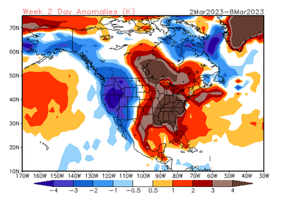
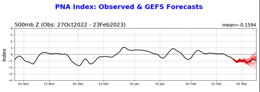
Morch starting out on the right foot. -PNA should help keep any cold air dumping to NW CONUS.
-
 1
1
-
1
-
-
20 minutes ago, OrdIowPitMsp said:
Time to focus on next week.

Hoping to start seasonal shift and convert all storms for me to rain.
-
1
-
-
3 minutes ago, SchaumburgStormer said:
F that. Incredible, but F that.
Yup where I live now was in the most destructive swath of that storm.
-
9 hours ago, SchaumburgStormer said:
Was that the storm that supposedly had reports of 5” ice build ups?
Read this man.
-
Indeed. Even half of that accreting in the main band would probably be like a 1 in 100 year event for a given location.
Let’s do it. 1976 style.-
1
-
-
I’ll take the bait. BowMe = UMB Wx. If so, I have no ill will…welcome back.
Who am I?-
 1
1
-
-
10 minutes ago, Chicago Storm said:
some of you need to take a page out of cromartie's book.
every time he talks up a mild pattern and morch, he gets a solid snowfall.
It's all sleet. It's frozen hell.
-
4
-
 1
1
-
-
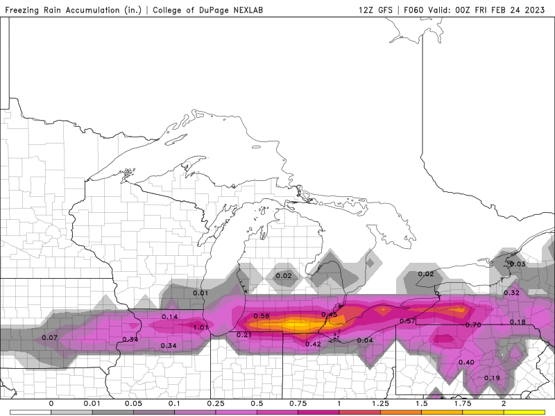
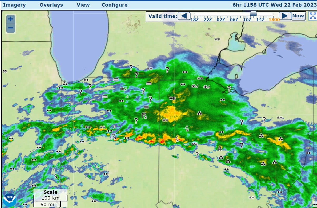
8 minutes ago, Chinook said:
Here are the observations from 6 hr ago. At Toledo we had ice build up a bit on maybe grass or elevated surfaces, but not roads I don't think. It was 32-34 degrees. It is still 34 but I don't think there's much more chance of ice accumulation. This map shows how close it was to being a thunder ice storm, which is exactly what you don't want.

I would love +TSFZRA
-
Getting ready to Morch.
-
5
-
-
15 hours ago, CheeselandSkies said:
2018 had pretty widespread/significant river flooding in southern Wisconsin, although it started later in the summer and continued into spring 2019 in some areas.
Then there was 2008...
2004 spring flooding was even better.
-
1
-
-
RFD should have been in ice storm warning. The band of ice storm warning counties is too narrow.
-
1
-
-
15 minutes ago, michsnowfreak said:
I got back from spending 5 days in the beautiful U.P. I got to see 5 more days with snow on the ground to add to the 25 days I've had at home, making this Winter a little more bearable. Had a great time with some gorgeous scenery but I do have to say the bad snow year is evident everywhere. I've been going to snow belt areas on a Winter trip for 17 years now and I can never recall seeing so few snowmobilers because the conditions are so bad. Many trails are dirt and ice. The snow pack was unusually low everywhere. There was around 15 to 18" of snow on the ground in Houghton. They should have about 3 to 4'. I stayed in a remote area near L'anse (just outside the huron mtns and keewenaw) and had 8 to 11" in the yard. There was grass with just patches and piles of snow at the mackinaw bridge and in St Ignace when you enter the upper peninsula. My brother, who joined us on the trip coming up from Chicago, noted that once he got north of Green Bay (where they had a few fresh inches of snow the day before) there was absolutely no snow on the ground in northern Wisconsin for a stretch. This made me think of beavis's rants and how even north of 45 North it is not a good Winter. It's a stinker and they happen. Next year is practically bound to be a better pattern (though I'm sure there will be have and have nots). The most snow I saw was near Munising, a bit over 2 feet (last year they had 4-5 feet otg at this time).
Climate change. Next year you gotta go to Thunder Bay
-
3
-
-
30 minutes ago, Baum said:
here is your answer:
PRECIP TYPE WILL STILL BE VERY TRICKY. THIS LOOKS LIKE A
WIDESPREAD SLEET EVENT FOR MOST.How well do snowblowers work with sleet?
-
1
-
-
1 minute ago, Geoboy645 said:
If we get substantial rain on top of the snowpack up north after this system. We are going to be in serious trouble for flooding on the stem rivers like the Upper Mississippi, Wisconsin, Wolf, Black, and Chippewa. That's how you get Nebraska 2019 but even worse.
Been awhile since a good spring flood. Let's do it.
-
1
-
-
3 minutes ago, UMB WX said:
Ice is south, snow is north. What's left?
-
1
-
-
56 minutes ago, UMB WX said:
It's gonna look like Ireland in a month.
-
1
-
-
28 minutes ago, UMB WX said:
You should post some backyard before and after pics of storm. RU ready to be buried? We need to beef your RD1 QPF up on the Euro/GFS
Rainer.
-
24 minutes ago, Harry Perry said:
The 12z RDPS would do it.
Too far south for me.
-
24 minutes ago, UMB WX said:
Can always tell when the NAM is on the juice. Saukville O/U 9.7"?
Hoping for a crippling ice storm. Set us back to the stone age.
-
1
-
-
4 minutes ago, mimillman said:
Ready for 15 degrees below normal in April and frequent RN/SN mix
not happening this year
-
1
-

Winter 2022/23 Banter Hangout
in Lakes/Ohio Valley
Posted
Might as well exclude the 1930s and some of the 1950s for heat then as well.