

hardypalmguy
-
Posts
1,030 -
Joined
-
Last visited
Content Type
Profiles
Blogs
Forums
American Weather
Media Demo
Store
Gallery
Posts posted by hardypalmguy
-
-
April is going to be one heck of a quick green up / leaf out month. Looks to flip to torch.
-
 1
1
-
-
MKE up to 39. Gonna be fun to see what happens.
-
1
-
-
4 minutes ago, snowman33 said:
Event starts in less than 12 hours. Then we'll see what happens.
Hoping it's all rain and they are left with their pants down on this one. MKE is 38F. Going to take a lot of dynamic cooling to get it to where this piles up.
-
2
-
 1
1
-
-
2 minutes ago, TheNiño said:
Well the general public can now go “omg Winter Storm Warning!” as they wake up. I’m sure it’ll be fine it’s Wisconsin lol.
They are laughing at the NWS.
-
5 minutes ago, TheNiño said:
I’m not sure you’re adequately separating the general public from weather weenies on this sub.
Again, do you think this has put the lives of the general public at risk? I highly doubt it.
It makes them incompetent. That's worse.
-
6 minutes ago, TheNiño said:
Why is a WWA —> WSW such a bad thing? How is the public put at risk?
Are you serious right now? The NWS did a wishy washy flip flopping in the last 12 hours. General public went from "OMG winter storm watch" to "ok no big deal just a WWA" to now "it's a warning now?" and the event hasn't even begun. Too much flip flopping. General public is now tuned out. They are already laughing about it on Facebook.
-
 1
1
-
 1
1
-
-
7 hours ago, RCNYILWX said:
Sorry you feel the way you do about our efforts. It's cliche, but in weather forecasting, there's always going to be a bit of 'you win some, you lose some.'
However, that being said, I can assure you the headlines are not based "off feeling." When there's a watch in effect and potential to upgrade to a warning, it's a collaborative intra office discussion, in addition to the inter-office collaboration that goes on. Last Thursday, we had about 3 hours worth of discussions on how to handle the existing watch, not exaggerating.
Since we inherited a watch on the (Wednesday) day shift yesterday, and it's within a timeframe when we usually make a decision, we're left with a) upgrade the watch or a part of it to a warning; b ) issue a WWA; c) hold onto the watch
Options a or b are the typical courses of action. Option C is what we went with for last Friday's event given the unusually large uncertainty up to go time. Preference today (including input up to local management level), was to go with the WWA as our highest confidence option. In that, we explicitly forecast up to 7" amounts in spots for the state line counties. That shows it's not as simple as 6" = definite warning.
My own thinking on the decision process was informed on how last Friday played out, with a similar expected 2m temp starting point at precip onset, and the 1-2 hour lag until progressively worse impacts, amidst intense snow rates and TSSN.
If part of the evening commute is spent in a lagged ground and pavement response prior to worsening impacts, and 12-hour amounts end up at 6" or less due to shorter duration of sustained heavy rates, plus lighter snow rates Friday AM with temps near to slightly above 32F, that's part of how we felt comfortable going with a WWA.
Confidence was not high in widespread 6-7" amounts per non-NCEP guidance being drier, and with much of the accums occurring at a less impactful time of day, we didn't think it necessitated a warning issuance.
This of course doesn't imply that we will be right, but shows the process that goes into headline decisions. There's also collaboration between WPC and the WFOs regarding QPF, SLRs and snow and ice amounts.
With the milder winter we've had, and no real classic winter storm setups this winter, we've been left with marginal and thus more uncertain synoptic evolutions. There is consistent post event evaluation going on that we use to build mental models of future events. But it doesn't ever make forecasts and headline decisions easy, and there's opportunities for future improvement that come about, from forecasts and headlines to our graphics and DSS.
Well we had MKE office drop a big ball on this one. Winter Storm Watch -> WWA -> Winter Storm Warning. I'm sure that left the general public either confused or they have now tuned it out completely.
EDIT: and all these changes before the event even begins. They should have either upgraded to a warning yesterday or held on to the watch until this morning if they were uncertain. IMO they handled headlines wrong on this one changing them this much before the event is even here.
-
1
-
-
14 minutes ago, Chinook said:
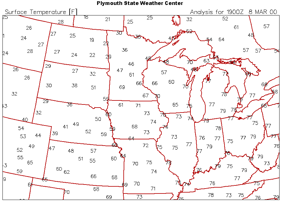
March 8, 2000? Weird.
it checks out
-
1
-
-
9 hours ago, mnchaserguy said:
If it makes anyone feel better, we will probably be paying for it soon. How much do you want to bet Minnesota will be stuck on the cold side of the warm front this spring while the rest of you get to enjoy the warm sector? Or it might just snow here until May. That’s also a possibility.
.I hope so. MSP can keep piling up the white gold.
-
1
-
-
38 minutes ago, OrdIowPitMsp said:
North, South, East, West. There really isn’t a direction this thing can trend away from MSP.
Ready 2b buried

-
2
-
-
There was a guy named wx on the boards years ago too. Smart guy.
-
tldr version for cromartie...
Cold washing out fast. Typical. -
Battle of the vet mets
JB v LC
Haven't seen such opposing thoughts in the long range. LC thinks the incoming cold late next week is out by mid month and we go back to modified pacific air. JB says brutal cold well into April. (shocking I know).
I'll be bump'n this one in a couple weeks.
I’d stick with LC. -
1 hour ago, SchaumburgStormer said:
Good thing my employer doesn't know how many hours of productivity I have lost over the past several seasons tracking phantom storms.
What's your name and employer -- I can help him out.
")
-
3
-
-
12 hours ago, Chicago Storm said:
didn't you used to have contact with dll years ago?
I still have contact with him on whatsapp. No idea where Bowme is.
-
Bring Bowme back. And daddylonglegs
-
Ya all can have it.
-
2
-
-
17 minutes ago, madwx said:
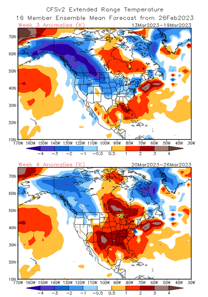
March 10-20 looks cold. It remains to be seen what happens after that, but the pattern should remain active through the month.
if "normal" is cold, then maybe. but I think March is going to be warm.
-
1
-
-
1 hour ago, A-L-E-K said:
maybe, how close are u, i'm just a block off the lake
3 miles
-
5 minutes ago, A-L-E-K said:
gonna be rough watching clumper aggregates bury s wi
cold rain for me.
-
30 minutes ago, WestMichigan said:
hardypalmguy is silent
lol. time to give up on wet dreams of cold.
") i heard it's nice in LA and Portland. Maybe Seattle will do good in March.
i heard it's nice in LA and Portland. Maybe Seattle will do good in March.
-
1
-
-
1 hour ago, madwx said:
2.15" of rain at the house so far today. normal Feb precip is only 1.52".
Went to check mine and it's recording 0.00. Wonder if it's still full of ice/snow from last week. Darn Vantage Vue.
-
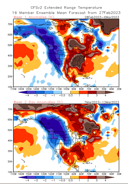
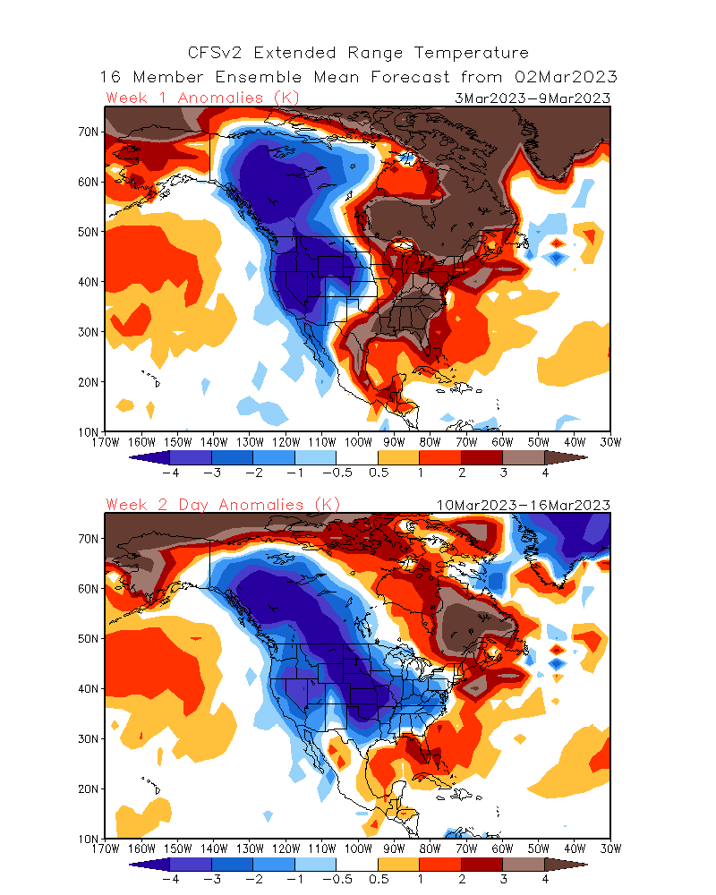
Cold back half of March hopes might be going up in springlike flames.
-
2 minutes ago, A-L-E-K said:
A couple more years and we'll be like Venus.
-
1
-

Spring 2023 Medium/Long Range Discussion
in Lakes/Ohio Valley
Posted
Delayed not denied. I'd rather have it in April tbh.