

Itstrainingtime
-
Posts
20,938 -
Joined
-
Last visited
Content Type
Profiles
Blogs
Forums
American Weather
Media Demo
Store
Gallery
Everything posted by Itstrainingtime
-

Central PA - Winter 2020/2021
Itstrainingtime replied to MAG5035's topic in Upstate New York/Pennsylvania
I think for those of us south of the 'pike, biggest question is how much do we lose to sleet if the coastal is tucked? -
Central PA - Winter 2020/2021
Itstrainingtime replied to MAG5035's topic in Upstate New York/Pennsylvania
LOL. Allentown gets 2' on the Canadian and literally nothing on the Ukie. Model madness! What will the next 48 hours bring? -
Central PA - Winter 2020/2021
Itstrainingtime replied to MAG5035's topic in Upstate New York/Pennsylvania
-
Central PA - Winter 2020/2021
Itstrainingtime replied to MAG5035's topic in Upstate New York/Pennsylvania
Agree 100%! -
Central PA - Winter 2020/2021
Itstrainingtime replied to MAG5035's topic in Upstate New York/Pennsylvania
No. That's why i posted that map. If I'm ever going to post a snow map, it's going to be something outlandish! -
Central PA - Winter 2020/2021
Itstrainingtime replied to MAG5035's topic in Upstate New York/Pennsylvania
RGEM doesn't look too bad down here...(over 30" in southern Lanco) -
Central PA - Winter 2020/2021
Itstrainingtime replied to MAG5035's topic in Upstate New York/Pennsylvania
CTP hoisted watches for the southern tier counties. -
Central PA - Winter 2020/2021
Itstrainingtime replied to MAG5035's topic in Upstate New York/Pennsylvania
Our friends down south are laughing off the NAM. Not a wise decision IMHO. -
Central PA - Winter 2020/2021
Itstrainingtime replied to MAG5035's topic in Upstate New York/Pennsylvania
@MAG5035 based on what you said this afternoon on how high amounts might go, is it safe to assume that the NAM is at the upper end of the envelope, potential wise? -
Central PA - Winter 2020/2021
Itstrainingtime replied to MAG5035's topic in Upstate New York/Pennsylvania
Correct - this is his 2nd first guess. Yesterday, nearly the entire SV was in his 12"+ range. -
Central PA - Winter 2020/2021
Itstrainingtime replied to MAG5035's topic in Upstate New York/Pennsylvania
As everything trends north today, DT goes south: Can someone explain to me what happens between the 8" purple line and the 8-12" red line? -
Central PA - Winter 2020/2021
Itstrainingtime replied to MAG5035's topic in Upstate New York/Pennsylvania
Widespread double digit amounts over the southern half of PA. -
Central PA - Winter 2020/2021
Itstrainingtime replied to MAG5035's topic in Upstate New York/Pennsylvania
CTP was calling for 2-4" for Lanco 36 hours prior to arrival in '96. I measured 30.5" 3 days later. -
Central PA - Winter 2020/2021
Itstrainingtime replied to MAG5035's topic in Upstate New York/Pennsylvania
GFS is 1-1.5" of QPF, all snow for us... -
Central PA - Winter 2020/2021
Itstrainingtime replied to MAG5035's topic in Upstate New York/Pennsylvania
Hard to tell exactly, but it looks like a general 10-15" with lolli's on the ICON. Northern NJ gets buried...looks in excess of 2'? -
Central PA - Winter 2020/2021
Itstrainingtime replied to MAG5035's topic in Upstate New York/Pennsylvania
MAG, that's a great call - thank you for your thoughts, as always. -
Central PA - Winter 2020/2021
Itstrainingtime replied to MAG5035's topic in Upstate New York/Pennsylvania
Thank you! Glad I wasn't the only one on that train. @Mshaffer526 you were watching this too! If this can keep going the other way (less confluence) our potential prize goes up... -
Central PA - Winter 2020/2021
Itstrainingtime replied to MAG5035's topic in Upstate New York/Pennsylvania
I'll be the first to throw the challenge flag... -
Central PA - Winter 2020/2021
Itstrainingtime replied to MAG5035's topic in Upstate New York/Pennsylvania
I gained about .5" of QPF from the 0z run. Verbatim...it's about 7" of snow for me. Last night's run was barely over 1". -
Central PA - Winter 2020/2021
Itstrainingtime replied to MAG5035's topic in Upstate New York/Pennsylvania
Look at how that hole over NE PA really eroded on the most recent run. That is what I wanted to see. -
Central PA - Winter 2020/2021
Itstrainingtime replied to MAG5035's topic in Upstate New York/Pennsylvania
To me, what I took from the Euro was 1) confluence eased off somewhat, and 2) the precip shield has a better east-west alignment today. Positives..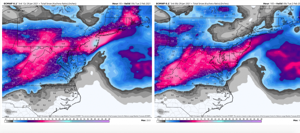
-
Central PA - Winter 2020/2021
Itstrainingtime replied to MAG5035's topic in Upstate New York/Pennsylvania
I just want that perturbation coming SE out of New England to relax and retreat. We need that to happen to end up really happy... -
Central PA - Winter 2020/2021
Itstrainingtime replied to MAG5035's topic in Upstate New York/Pennsylvania
It is indeed me...2019 in Washington DC at the international HR conference. I started every day there with a big a** bowl of Cap'n Crunch! -
Central PA - Winter 2020/2021
Itstrainingtime replied to MAG5035's topic in Upstate New York/Pennsylvania
I've never once had them. -
Central PA - Winter 2020/2021
Itstrainingtime replied to MAG5035's topic in Upstate New York/Pennsylvania
Fair enough. I'm not here to cast doom and gloom. I've been going on 3 hours sleep all week solely to stay up for the Euro, hoping and hoping that I see something that I like. The past 2 days I haven't seen that. I'm not here to piss on Cheerios, I'm here because I have a passion for weather in general, snow in particular, and I love to read and share. Funny, by nature I'm known as an extremely positive/optimistic person, but, and this is a big but...I do not roll with blinders on. I will not ignore negative things and pretend they don't exist. I tend to be the first, or one of the first, to throw the challenge flag in this thread. I've been an ardent follower of the weather since 1972. I've learned a LOT over the years, received a 104% final grade on Meteo in school, and would have pursued my met degree in college if life wouldn't have thrown me a curve ball years ago. You've said this yourself - it's easy to be negative because more often than not, we fail when it comes to snow. If i downplay and you hype every potential event, I'll be right more than you. We know this, but that is NOT my intent. I try and share the why. And there are times when my "why" is off base even though I end up being "right" but the bottom line is this - I'm really just trying to be objective. Sometimes I take it too far, yes. But look...I want it to snow. Like really, really bad. And I'm looking for signs that this thing is going to come back.


