

WinstonSalemArlington
-
Posts
3,865 -
Joined
-
Last visited
Content Type
Profiles
Blogs
Forums
American Weather
Media Demo
Store
Gallery
Posts posted by WinstonSalemArlington
-
-
Virga marches south and east

-
 1
1
-
-
It’s radar watching time. Virga underway in the Triad and border counties
-
3
-
-
32 minutes ago, Regan said:
And he bumped up here in Wake down. Right as I was getting excited about the Nam. I mean… at least gimme 6.

Bumped up in western Triad
-
-
Virga in the northwest Triad

-
1
-
-
Whatever happened to meteorology at the venerable WBTV? No one ever talks about their meteorologists anymore

-
18 minutes ago, USCG RS said:
Snow growth regions, especially in the south, tend to be at or just below the 500mb (h5) level. However, the cold down here is very anomalous, as such, the best snow growth region will be shunted to the 700mb (h7) level for this storm.
So for this storm when a forecaster is looking at h5 and sees very low relative humidity (RH), they are seeing low moisture and thus low snow growth potential. However, h7 is full of RH and in this case, this is where we should be looking for snow growth (commonly known as DGZ - Dendrite Growth Zone). As such, while h5 might look like a dry slot or poor snow growth, this forecast should rely on h7 which looks great.
This is golden education. Thank you
-
3
-
 1
1
-
-
-
21 minutes ago, NorthHillsWx said:
That’s better than it was looking.
Much better
-
Surface app at 12:19 pm

-
1
-
-
There is no law that says it can’t snow on weekdays

-
2
-
 1
1
-
 1
1
-
-
4 minutes ago, Met1985 said:
Wrong thread bro.
Oops my bad
-
 1
1
-
-
LilJ has been drafted to start the February 5 thread when the proper yoke comes

-
6
-
3
-
-
February 5
-
1
-
-
-
Valentines

-
1
-
-
Ben Noll, WaPo

-
1
-
-
-
GEM blesses almost everyone in the Carolinas and SoVA

-
3
-
-
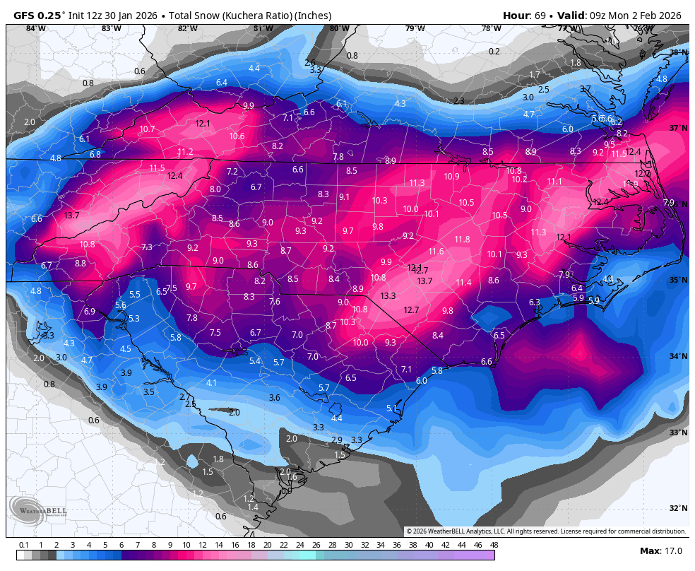
6 minutes ago, wake4est said:
GFS drops ANOTHER 10 inches of snow on Thursday in central NC.
And I fell out….

-
2
-
5
-
-
-
11 minutes ago, eyewall said:
I accept this run")
Where is that fainting church lady gif?
-
 1
1
-
-
16 minutes ago, mclean02 said:
That storm was legendary with the lady on the phone and car on fire on the hill lol! Which one was that ?
It’s a legendary weather meme for all time
-
2
-
-
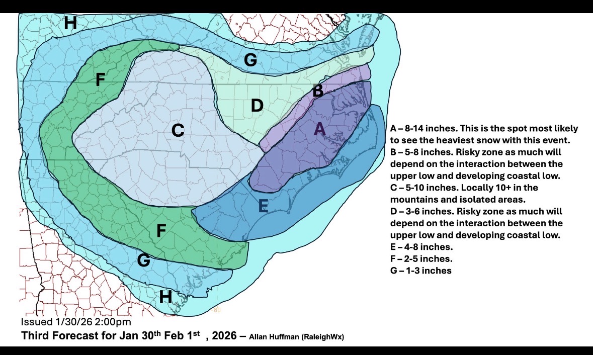


January 30th- Feb 1st ULL and coastal storm obs
in Southeastern States
Posted
Flurries have begun in Boone