

dWave
-
Posts
1,825 -
Joined
-
Last visited
Content Type
Profiles
Blogs
Forums
American Weather
Media Demo
Store
Gallery
Posts posted by dWave
-
-
49 minutes ago, lee59 said:
I have never seen the site in Central Park but I wonder if they want to keep it somewhat hidden because of possible vandalism. Of course they still can keep it reasonably under control with the overgrowth.
I've always suspected that is a factor. If it was out in the open I'm sure someone would mess with it just because. You still can now, its just not very noticeable unless you are looking for it.
-
10 hours ago, bluewave said:
That’s not what the raw data says. The minimums and maximum departures have been running lower than the surrounding ASOS sites. NYC has also been running colder than many of the micronet sites. The first freeze in NYC was much closer to the recent average date than areas away from the heat Island. POU had one of their latest first freezes on record. While NYC wasn’t even close to its latest first freeze.
NYC had the lowest temperature on the coldest morning this week for surrounding urban sites
11-24 low temperatures
EWR…32
NYC…30
LGA….33
Corona….32
Queensbridge….32
East 40th Manhattan….33
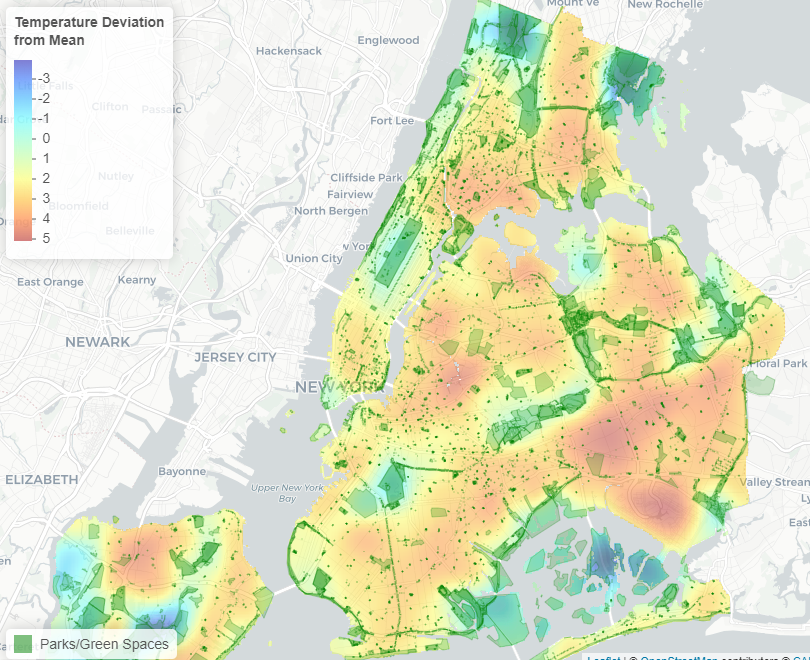
Mapped UHI shows Central Park ( or any large park) isn't a great representation of the day to day experience in NYC. Being in an open field instead of directly under a canopy of trees would help some at least. Manhattan in general looks the coolest on average, at least in the daytime. Particularly Midtown and Lower Manhattan, thanks to extensive shade from high rises.
"Using satellite data from the US Geological Survey’s Landsat 8 satellite, the New York City Council’s Data Operations Unit put together a map of how temperature varies across the city..."
https://council.nyc.gov/data/heat/
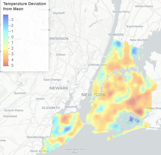
Matched up with parks highlighted. Largest NYC parks: Pelham Bay (1st), Greenbelt, SI (2nd), Van Cortlandt (3rd) are the coolest places, as expected.
-
Freeze warning this am..holding steady at 33. Coldest night so far
-
8 hours ago, bluewave said:
The near record warm ocean is more impressive. Long Island pushing 60° with a southerly wind. The SSTs are still near 60° in late November.
Shirley CLEAR 59 51 75 S9

I saw somewhere it's considered a marine heat wave now off the northeast coast. They concluded this marine heat wave was a significant factor in the record rain and flooding in the Ida remnants event.
-
 1
1
-
-
2 hours ago, SnoSki14 said:
Must be a concrete jungle. We've had multiple freezes already in central NJ and seen 20s at least twice.
I thought it'd get a few degrees colder here. Wind seem calm..ideal for most places but I've heard it been said calm winds isn't always the best in the most urbanized areas for coldest temps since a breeze can act like a fan on the UHI.
Sat am first shot at freezing?
-
1
-
-
41 after a low of 39. No frost. Tomatoes, peppers etc live on
-
37..tied coldest of the season so far.
Frost advisory tomorrow am for Bronx, Manhattan, Hudson County, NJ, Southern Nassau
-
1
-
-
Wow maybe my first real hail storm within NYC I've seen. Not just occasional pellets but heavy hailstorm with some acclumation
-
4
-
-
Some very strong winds howling in lower Manhattan. Didn't expect winds that strong. Workout for the day walking against it. With it alot of temps in the upper 60s now
-
45 after a low of 40. Finally can see some significant foliage in the 5 boros, but still below 50% overall. Look like real explosion of color as close as north half of Yonkers or so.
-
1 hour ago, LongBeachSurfFreak said:
35 at the wantagh meso, so I’m sure frost verifies on the south shore of Nassau. There wasn’t any yet when I left for work on the uws at 445. Temps fell an additional 2-3 degrees after I left which should have made the difference
Patchy frost at best type morning in or immediately near NYC. Saw frost on cars parked along Bronx Park E along/near NY Botanical Garden. A block away from the park, nothing. Drove through Pelham Bay Park and saw some patchy frost, then into dtwn New Rochelle where I saw none. If you're block is leafy enough it pushes you over the edge
-
4
-
-
4 hours ago, Snowlover11 said:
dear lord at the bust calls
 this was a given a break till later tonight. another 1-2” iso 3” amounts are possible later this evening into early morning
May not end up a bust but I can understand why ppl would think that. After 10 am ish It was a dry day with some breaks of sun today. A lul is one thing. Its not a lul anymore when it's all day...and not even some light showers or drizzle during the day. Especially compared to the hype it might seem a dud, at least at up to this point. I personally have no problem with that either. I've seen enough flooding this yr.
-
-
Temps on the rise once the hazy sunshine finally broke through. 77 dew 67
-
13 hours ago, LibertyBell said:
I mean JFK and EWR have always been cooler on radiationally exceptional nights, it's usually 2 degrees cooler for JFK which is something I've noticed, but sometimes it can be much more than that, up to 10 degrees colder on exceptional nights when there is no wind and the skies are clear all night.
Yeah I always figured EWR and JFK radiate better at night. LGA isn't bordered by marshland or anything. It's highly urbanized and dense right up the the runways lol. Thousands of ppl live right across the street from LGA. It is on the East River but right across from Rikers and very industrial Hunts Point. A N to NW wind is coming off the south Bx and traffic clogged Bruckner, Major Deegan etc. LGA is a good representation of standing waiting for a bus on a city street or day to day life is like. Central Pk is what a picnic in a shady park is like, and JFK is what a day at the beach is like.
-
 1
1
-
-
1 hour ago, bluewave said:
It’s a shame the higher up officials at the NWS let the trees grow over the sensors starting around the 1990s. We have demonstrated how the high temperatures have cooled relative to other stations since then. The cold bias was recently fixed at the Albany airport. But that fix may have been prioritized due to flight safety. The accuracy of the climate record of the biggest city in America should be just as important even though it’s not at an airport.
https://altamontenterprise.com/09162021/albany-airport-needs-more-accurate-thermometer
Albany airport needs more accurate thermometer
One would think the National Weather Service, being the steward of accurate weather detail, would seek to have an accurate thermometer. We all have heard that a global average warming of just 1.5C (about 2.5F) could wreak havoc on our planet. So, if the thermometer at the Albany International Airport is measuring 2.5 degrees too low, as I believe it is, this cool bias reading might mask any significant warming.
Assuming that is the case, an accurate thermometer is just as critical to the aviation industry. If the actual temperature is 34 F, but the Automated Surface Observing System thermometer records a temperature of 32 F, the pilot might have to be concerned about freezing rain versus liquid rain, which makes a huge operational impact.
Perhaps the worst part of all this, is that our monthly records with this known cool bias, keep going out to the world and would suggest our climate is locally cooling, when really it is not.
The folks at the local National Weather Service in Albany are not to blame. They have done all they can to inform the higher officials of the problem. I suggest you call your local Congress member and hopefully they can put pressure on the higher officials of National Weather Service to change the thermometer before further damage can be done to the climate records and have a reliable accurate temperature sensor.
https://nwschat.weather.gov/p.php?pid=202109301152-KALY-NOUS41-PNSALY
PUBLIC INFORMATION STATEMENT
NATIONAL WEATHER SERVICE ALBANY NY
752 AM EDT THU SEP 30 2021

...PUBLIC INFORMATION STATEMENT...

...NATIONAL WEATHER SERVICE REPLACEMENT OF THERMOMETER AT
ALBANY INTERNATIONAL AIRPORT...

THE NATIONAL WEATHER SERVICE RECONDITIONING CENTER (NWSRC) REPLACED
THE AUTOMATED SURFACE OBSERVING SYSTEM THERMOMETER AND ASSOCIATED
ELECTRONICS AT THE ALBANY INTERNATIONAL AIRPORT YESTERDAY,
SEPTEMBER 29, 2021 AT 9:30 AM. THE THERMOMETER WAS REPLACED WITH A
MODIFIED SENSOR AND CALIBRATED WITH A MODIFIED ALIGNMENT
PROCEDURE.

A REFERENCE THERMOMETER, RUNNING SIDE BY SIDE WITH THE ASOS THERMOMETER,
HAS COLLECTED DATA FOR COMPARISON SINCE JUNE. THE PREVIOUS
THERMOMETERS INSTALLED SINCE JULY 17, 2020 LIKELY HAD A COLD BIAS
(THERMOMETER RECORDS A COLDER TEMPERATURE THAN THE ACTUAL
TEMPERATURE).

THE NATIONAL WEATHER SERVICE WILL CONTINUE THE INVESTIGATION ON THE
COLD BIAS IN THE ALBANY TEMPERATURE RECORD FOR THE PERIOD JULY
17, 2020 THROUGH SEPTEMBER 29, 2021.

PLEASE CONTACT SUSAN BUCHANAN, DIRECTOR OF PUBLIC AFFAIRS, NATIONAL
WEATHER SERVICE AT 301-427-9000 FOR ADDITIONAL INFORMATION.
I can't see NWS doing anything besides the status quo. It would take some tragedy unfortunately, like a catastrophic heat wave that was underestimated due to a pigeon hole focus on Central Park readings.
Better off trying to get media to incorporate other NYC stations more prominently in their forecasts etc.
-
Saw some minor/nuisance coastal flooding earlier at high tide along the Sound btwn Pelham bay, Bronx and New Rochelle on a howling ENE wind
-
On 10/4/2021 at 6:14 PM, Rjay said:
If you just go with AN temps and AN snow every year it'd be a decent forecast for our sub.
I wonder if that is becoming a permanent feature in our climate or is this a period of transition before snowfall start falling to match our warming temps. Like DC for example where the snowfall avgs have been plummeting, matching warming temps. It might as well be ATL there now. For now I think having more favorable storm tracks and more precip overall continue to overcome the warmth, but for how long?
-
3
-
-
Warm day but a coolness still in the shade with the low humidity, an impressive 77 today. Feel good about hitting 80 tomorrow.
-
1
-
-
5 hours ago, LibertyBell said:
Think the smoke might actually keep the temps down?
NWS forecasts have dropped a few degrees I noticed, I suspected thats why. Not a huge difference, but some upper 80s are now mid 80s. Mid 80s days now low 80s.
-
1
-
-
47 minutes ago, MJO812 said:
Another rainy day
^^^The caption of summer 2021..at least the weekends
-
2 hours ago, Snowlover11 said:
traffic was a nightmare this morning leaving work what should be a 5-10 minute drive home, took me over an hour and 30 mins to get home.
Yeah..still is. The sunshine is deceiving. In early afternoon the major deegan was still flooded with lines and lines of cars and trucks abandoned in the water. Also additional runoff out of Van Courtlandt Park and down from Westchester was flowing onto the highway. Bx River Pkwy looks similar still. I had to drive a little I stuck to local streets.
-
1
-
-
At least 8 deaths in the area, 7 within NYC, most were people in their suddenly flooded homes.
-
 2
2
-
-
4 minutes ago, stockmanjr said:
Current road situation....
I was about to post the same.. its all closed, including streets not usually prone to flooding. That's flash flooding..then there is river flooding to come, how that will rank historically will be interesting
-
1
-
November 2021
in New York City Metro
Posted
Moderate to occasionally heavy snow in lower Manhattan