

tuanis
-
Posts
741 -
Joined
-
Last visited
Content Type
Profiles
Blogs
Forums
American Weather
Media Demo
Store
Gallery
Posts posted by tuanis
-
-
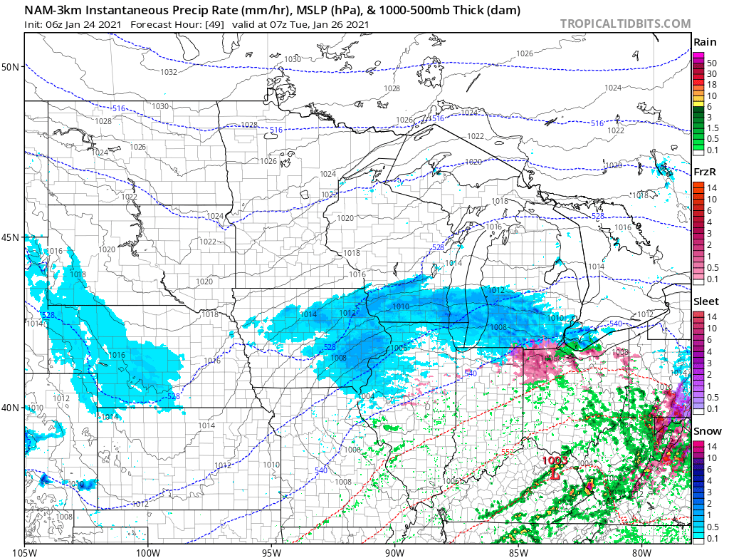
This banding does give hope for the rest of the night. If one finds themselves sitting under one of these bands, the reports of solid dendrites means you can really stack. Get the lake involved an all bets are off. Let's get these ingredients to come together.
-
 1
1
-
 1
1
-
 1
1
-
-
Dryairpalooza. So much for this thing starting with a bang. DSM looks good though. Weird storm, but somehow fitting for this winter.
-
 1
1
-
-
Saturation underway. Wonder if precip breaks out ahead of schedule. LOT is saying 6 PM up here, hi-res models say 7-9 PM. Just picked up a bunch of dog turds half-buried in the glacier that's been around for more than 3 weeks before they get snowed over. Pretty stiff NE wind out there.
-
2
-
 4
4
-
-
Per 3k NAM best fgen banding lifts well into WI on a roughly Platteville - Madison - Port Washington line with some showery garbage to the south. Wouldn't be surprised, although lake should help within 10-15 miles of the lakefront between Chicago and Milwaukee. I'm 5 miles due west of the bluff in Lake Bluff and am counting on the lake contribution

-
1
-
-
7 minutes ago, MIstorm97 said:
My buddy Dan just said 7” in Lincoln with ripping snow rn.
7" so far with a radar signature like that? No doubt they'll hit the higher end of the 8"-12" forecast. Omaha and Nebraska City areas look primed as well.
-
Just now, homedis said:

Already a dusting... more than I imagined for the entire storm down here in Champaign lolSweet view
") Enjoy the morning flakes.
Enjoy the morning flakes.
I've got a bunch of friends in Northbrook, so will get you a report on how things look back home.-
1
-
-
The disturbance passing south on Wednesday looks to add plenty of moisture to the mix, bumping up the plume and kicking it further west for a bit.
-
Thread has gone quiet. Maybe we're all relishing in the Packers' loss.

Hate relying on lake effect/lake enhancement to make up for a less impressive synoptic system than progged. Can be so fickle.-
2
-
1
-
3
-
1
-
-
5 minutes ago, mimillman said:
I sincerely doubt LOT goes with an advisory for the largest storm in the metro in 3 years and the largest event by far of the season.
Tough call for sure. I could see the initial burst of snow maybe getting close to 6-hour warning criteria, but rates look to drop off pretty quick. Glad I’m not making the call.
-
I’ll stick with my 6.5” MBY call, but I’m not feeling too confident. This morning’s turd duster was all needles and while tomorrow’s an entirely different system and moisture source, I imagine that while the initial push may impress - dry air, diminishing radar returns, and poor accumulation efficiency will plague the rest of the event, even with modest lake contribution.
Due to duration and anticipated light/moderate rates I would think LOT goes with an advisory and MKE does the same for its southern tier of counties.
Funny, a day or so ago people were talking blizzard conditions.
At least it should end up being better than anything else we’ve seen this winter. I hope!
-
1
-
2
-
-
12 minutes ago, Baum said:
I always think a good heavy hit at onset is key for a good event. Sounds redundant, but the big winners get hit fast and hard.
I feel like the big winner is often where that fgen band slows and stalls, then pivots back over with the defo. In the case of the latest 3K NAM, that looks to occur just north of the border. It moves through the metro too quickly as depicted to dump much. (Long range NAM caveat applies obv).
-
6z run of the 3K NAM blasts the dry slot much further north, pushing the best fgen into southern WI after the initial band and before the mediocre defo moves overhead. It’s long range for NAM, but I feel like 8 out of 10 events surprise with how far north banding ends up. Something to keep in mind as we get closer.

-
1
-
-
Ride’s not over yet

-
3
-
-
Question is how far north will the dry slot push to shut off precip/drizzle on us before the defo establishes itself and swings through. I imagine models will be narrowing in on that over the next 48 hours. Could easily push dynamics north for awhile. Perhaps even into WI.
-
This thing gonna be a Border Bomber? NW shift resurrected? Has Geos returned?
Iowa looks to get crushed.
-
Just got home excited to catch up on this thread and it’s been kind of like reading the comments on a teenybopper YouTube vid. Those contributing solid analysis despite the noise, well done.
Still looks good for the metro and still like where I sit. I’ll set my expectations at a realistic 6.5” and enjoy the storm from here on out. Sounds like duration with flakes in the air will be solid. Kids are pumped for an actual snowfall not bungled by sleet and rain with hopes of building an epic snowman.

-
4
-
-
Just now, A-L-E-K said:
there are more big dogs at MKE than ORD

We're nowhere near done with the surprises on this one. Plenty of runway left.-
1
-
2
-
-
7 minutes ago, weathafella said:
Toss uncle.

-
2 minutes ago, andyhb said:
This thread is a ****ing trainwreck right now.
Just wait until the 12z Euro comes out

Still not ready to bite on this one yet, but I'm certainly along for the ride. -
2 minutes ago, McHenrySnow said:
Couldn't agree more. Hard not to see that nightmare scenario work out and we get completely shafted. Nerve-wracking.
Pattern looks sloppy behind this thing, too. Hope it works out.
-
1
-
-
Patiently watching this one unfold. Seasonal trends for the past two years warn me it still could shear out into a pile of garbage. Worst case scenario would be the precip associated with the wave on Saturday night missing north into Wisconsin, then the main low Sunday>Monday being suppressed with little wintry precip even downstate. Liking where I sit, but we've really been through the ringer with events not coming together the past two years.
-
2
-
-
Cool little feature. Damn we’re all so thirsty in here.
-
1
-
-
1 hour ago, mimillman said:
Decent flakes here, clearly no issues with saturation for tonight's snow.
Expecting 1" on grassy surfaces
Based on regional radar sure looks like the accumulating stuff will fall in southern WI. Not like it'll amount to much up there either.
-
45 minutes ago, MoresnowthanU said:
It tried to accumulate for a second.

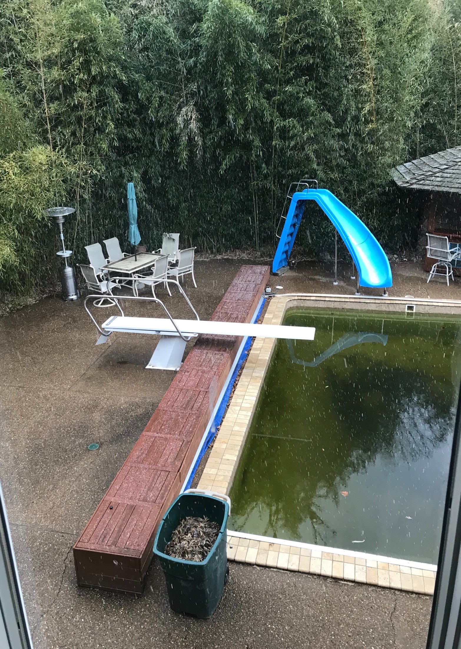
Is that all bamboo?
Jan 25-26th Potential Something Part 3
in Lakes/Ohio Valley
Posted
March 12-13, 2017. I recorded 14" of LES IMBY. It can happen!
