

NeonPeon
-
Posts
1,041 -
Joined
-
Last visited
Content Type
Profiles
Blogs
Forums
American Weather
Media Demo
Store
Gallery
Posts posted by NeonPeon
-
-
Snowing nicely once the lull ended. There was zero mixing.
-
 1
1
-
-
Someone from Maine the other day said they might be relocating down here, and what was the winter like.
What I should have said was well, do you like looking up through the rain at a street lamp, and convincing yourself through sheer will, that droplets of rain have pseudo crystalline structures? Because if so, boy, oh boy, are you going to love it down this way.
I've spent hours with this street lamp. Many things lie in the world of meteorology, if you aren't rigorous in your probabilistic thinking. That street lamp though, it's a straight shooter, the wretched bastard.
-
2
-
 4
4
-
 1
1
-
 1
1
-
-
7 minutes ago, marsman said:
Oscar?
Such a tiny little core. Wonder what the ceiling is.
-
20 minutes ago, EWR757 said:
I strongly disagree. There are risks and consequences associated with "preparing".
Many educated people I know did not understand this storm would begin to dissipate before it made landfall. Many people prepared for a CAT 5 and that was NEVER in the forecast.
Sometimes reacting causes more problems than sitting quietly.
The educated people you know can't read a weather forecast then.
Preparing for the worst here meant a very normal track deviation of just a few miles in either direction causing the worst of a storm surge to go into one of two bays, it had nothing to do with the storm being stronger than forecast.
-
2
-
-
1 hour ago, SnoSki14 said:
I meant the state as whole will fare okay. Sure local hard hit communities will face issues but this won't be the disaster the media said it'd be.
You've started strawmanning "FLORIDA WILL BE WIPED OFF THE FACE OF THE MAP, THIS IS THE END TIMES" and now are in the position of waving away significant destruction, even as it's being uncovered.
Stop responding to stupid media by having diametrically opposed equally stupid opinions. Stop characterizing the most extreme opinion as definitive. That is why public discourse is broken.
Try ignoring the sensationalism, listening to the calm, intelligent voices, then you can have an adult conversation. Or, carry on, I guess.
-
4
-
-
9 minutes ago, gymengineer said:
Agreed on the complexities of storm surge. Just look at Ivan and Katrina for examples of very high west of landfall storm surges, while many other hurricanes do not have appreciable storm surges in that direction. Or Florence's Neuce River surge outperforming, or Dorian's surge on the backside of Hatteras. The storm surge forecasts are still the "weakest" part of the NHC products because of all the variables.
I also want to note that easily verifiable facts are available to us this morning. Milton's storm surge was higher at both Ft. Myers and Naples than Helene's- significantly higher at Naples. Posts in the main thread seem to be speaking about the Tampa area only when comparing to Helene.
Fort Myers they were almost identical. Naples a foot higher, yes. I think that reflects the fact that the hurricane at a lower latitude was stronger, and that in this case anyway, the surge was reactive to the immediate intensity. When I was watching Naples yesterday, I thought we'd see much more surge than Helene in the area between Bonita Beach and Englewood, say. I certainly thought that Fort Myers would be significantly higher than Helene, and it was basically the same. Obviously that narrow band that got the worst onshore wind got whacked, and that never happened with Helene as it was miles away.
I think the fact that Milton was small also means that the direction of wave travel wasn't the same, nor for as long a period of time. You can see that in the fact that the surges recorded for Helene are broader, instead of spikes you have hills.
-
20 minutes ago, gymengineer said:
This banter thread and the main thread are indistinguishable at the moment. It’s always the case the morning after a hurricane landfall that the vacuum of information leads to lots of guess posts. What’s most amusing is the 10’ above normal water level trace near Sarasota, with Helene’s much lower height visible, juxtaposed to these confident posts that the storm surge underperformed.
You can compare the forecast surge to the reports we do have and draw your own conclusions without being obsessed with overperformance/underperformance or somehow emotionally involved. Surge is an interesting thing to discuss because it doesn't have a linear relationship with storm strength and has many confounding variables including very granular detail with regard to final landfall track, the tide, topography of bays etc. etc. There had been a prevalent thought that this storm would punch above its weight surge wise due to its antecedent strength. That doesn't seem to be the case, in that the really damaging worst case surge we see is is mainly confined to the southern side of the core of the storm, which was afterall quite a small area relative to other hurricanes, but there are lots of details to this. For instance, the breadth of its surge at the lower end is in keeping with the forecast, with areas like Naples and even further south getting surges in line with forecast. The higher end of the forecast also seems to have verified, but in a narrower band.
There's also the risk management side to the forecast in terms of messaging. Forecasters became increasingly confident that landfall north of tampa bay wasn't going to occur, but the risk was massive. Narrow or not, if the worst surge was someplace else, just a little further south in Charlotte Harbor, or a little further north in Tampa Bay, and you see worse effects and they had to be advertised.
The other thing occurring is it's pretty natural to make comparisons between this and the previous hurricane, especially in areas where there are similar effects despite completely different tracks. Size matters.
-
1
-
-
5 minutes ago, CoastalWx said:
It was a small sized storm until last minute really. That helped. But I think Port Charlotte got it real good.
I'm not sure. I know someone on Pine Island, and the surge was bad but not as bad as Helene. Obviously it greatly matters exactly where you are, but excepting the area that got really nailed with the back end of the eye, the surge seems significant but not catastrophic.
-
The surge seems to have been less broad than expected in terms of the area affected with the worst of it. Many places were on the level of Helene.
The other thing is that this thing threaded the needle in terms of surge. Charlotte Harbor was just south of the worst and east of it when the storm came in, and the worst surge seems to have behaved like this was a small hurricane, with a small core, even though the windfield was more dispersed. Obviously a bullet was dodged with Tampa Bay also. So it would have been worse further north, or further south.
-
1
-
2
-
-
Ft Myers water level has now peaked. Slightly higher than Helene but two feet lower than Ian. Now second worst since that station was in.
The surge forecast around Tampa Bay is just having to sit on a fence, given uncertainty of landfall detail, but the south of landfall storm surge seems to be underperforming expectation in general thankfully. The surges we can see so far are very similar to Helene, which while such a big beast, passed these areas so much more distantly, and without these winds driving the water.
-
 1
1
-
-
Fort Myers at 5+ ft of storm surge, still increasing.
https://tidesandcurrents.noaa.gov/stationhome.html?id=8725520
-
Naples surge seems to have peaked.
Fort Meyers shooting up at the moment. Unfortunately there's no data for any of the places you'd expect to have the worst of this.
-
1
-
-
You are fighting a strawman.
Yes, there was overhyped coverage of this storm, if you consume awful media, just like there's awful coverage of all sorts if you don't know what to read and how to read.
What there really was, from professional places, whether less sensationalized news or otherwise, was the distribution of a very accurate forecast that seems to be verifying with some really significant accuracy. The uncertainty baked into that forecast is necessary, and yes, it could have been worse if this was N of tampa, but the very near risk of that happening, given the uncertainty, meant that that worst case scenario, still eminently plausible, needed to be discussed and communicated, and acted upon as though it came to pass.
Now, if some cretins were talking as though this hurricane was going to be a cat 5 at landfall and erase Tampa off the map, then those folks are idiots, however I haven't heard them on here. The vast majority of discussion has been reasonable, and thanks to the mods for that. Yes, people nerded out when the storm achieved as close to perfection as a hurricane can. That's kindof what a weather nerd of any stripe should do. The idiots I've heard most today have been an entirely different, equally unhelpful flavor.
-
1
-
 1
1
-
-
2 minutes ago, dbullsfan said:
I don't mean this to sound like evacuating from highly dangerous areas isn't important. It absolutely is. That being said I wonder how many people on the west coast/central Florida evacuated to some of these places on the east coast that are just getting crushed with Tornadoes today.
And it would remain a sensible risk assessment.
-
1
-
-
2 minutes ago, jrips27 said:
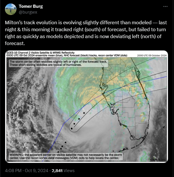
How is it deviating from a forecast while remaining within the cone? I thought the idea explicitly was to not pay attention to the center line, hence removing it.
-
1
-
-
The earth is 4 billion years old, some dates for the biblical flood something around 2300BC. Property development on the west coast of florida... that strikes me as relatively modern.
To give some actual context, the population of the world during biblical floods was less than 3 times the population of just Florida's population, now. In other words biblical floods aren't biblical, as concerns human impact. Modern floods are far more biblical, excepting the fact that oddly we know about their statistical likelihood and build the way we do anyway.
The only relevance to the bible here might be the bit about the foolish man who builds his house upon the sand.
-
1
-
-
4 minutes ago, Amped said:
The severe is overperforming so not a bust.
The two main effects of this storm that have been underscored are 1) storm surge and 2) a heavy rain event including PRE
I could ask what the obsession with bust is in general, but I'd imagine the things need to have a chance to occur or not before you can assess... whether they've occurred or not.
The tornados are an unwelcome surprise.
-
14 minutes ago, weatherwiz said:
The last several scans are jaw dropping. Was looking at the IR one second and look over like 5 minutes later to see rapid developing of convection, convection wrapping around, and the eye clearing out...yikes.
It also seems to me like the storm is not necessarily fighting the stronger wind shear to the north but its structuring itself to avoid the shear or have the shear lessen its influence...wild.
The fact that the core of this storm is so small seems to help it. Most storms would be struggling with the constraints to the NW.
-
1
-
-
24 minutes ago, WxSynopsisDavid said:
Milton is beginning another Rapid Intensification process. Should shear continue to relax, this will be Milton’s last chance at making a run at peak intensity. Milton starting to move over a warm eddie. Should be over this warm eddie for the next several hours. Later today into the evening and overnight, Milton will be over the Gulf Loop Current.
I don't think it's possible for this hurricane to rapidly intensify, by the meteorological definition, or even as a loose descriptor, thankfully, unless it had weakened more. It's too close to its ceiling.
-
1
-
1
-
 1
1
-
-
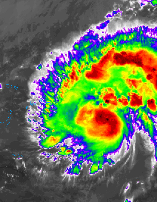
Not seeing any evidence that its reintensifying after replacing the eyewall. The eyewall itself looks ragged on IR. Obviously its still a beast but the less intensity it has before it gets sheared the better.
-
 2
2
-
1
-
-
20 minutes ago, DDweatherman said:
There’s reason to believe it was even lower at peak given the recon left before the “best” satellite images. we’re blessed here to have them in at the peak times.
Not to be picky, but I think this looked better an hour or so ago. At the end of the day, they aren't going out to collect trivia for us.
-
1
-
1
-
-
4 minutes ago, StormChazer said:
The eye has gotten unbelievably small. If this is the start of an EWRC, I just hope recon gets there first so we can give this thing the records it deserves.
It looks to me like it's just losing the perfect donut look, perhaps due to ewrc.
-
1
-
1
-
-
1 minute ago, kdxken said:
How much storm surge did they get with Helene when all was said and done?
It was like 6-8 feet around tampa bay, I believe.
-
1
-
-
It's very impressive, but it looks to be the most obvious RI we've ever seen.
This storm has had the absolute perfect conditions and precocious structure. It has lead a charmed life. I'm interested to see how it will integrate it's one imperfection as it continues to deepen - that blob to the NE.
As WAR expands, do our snow chances increase? First wave may produce a middling event-solid advisory and possible low end warning for MLK Weekend
in New England
Posted
I know, whatever next.
Big wet flakes.