

Weatherdemon
-
Posts
401 -
Joined
-
Last visited
Content Type
Profiles
Blogs
Forums
American Weather
Media Demo
Store
Gallery
Posts posted by Weatherdemon
-
-
Special Weather Statement
National Weather Service Tulsa OK
222 PM CST Thu Feb 11 2021

ARZ001-002-010-011-019-020-029-OKZ049-053>076-121100-
Benton-Carroll-Washington AR-Madison-Crawford-Franklin-Sebastian-
Pushmataha-Choctaw-Osage-Washington OK-Nowata-Craig-Ottawa-Pawnee-
Tulsa-Rogers-Mayes-Delaware-Creek-Okfuskee-Okmulgee-Wagoner-
Cherokee-Adair-Muskogee-McIntosh-Sequoyah-Pittsburg-Haskell-
Latimer-Le Flore-
Including the cities of Rogers, Bentonville, Berryville,
Eureka Springs, Fayetteville, Springdale, Huntsville, Van Buren,
Ozark, Charleston, Fort Smith, Antlers, Clayton, Hugo, Pawhuska,
Bartlesville, Nowata, Vinita, Miami, Pawnee, Tulsa, Claremore,
Pryor, Grove, Jay, Sapulpa, Okemah, Okmulgee, Wagoner, Tahlequah,
Stilwell, Muskogee, Checotah, Sallisaw, McAlester, Stigler,
Wilburton, and Poteau
222 PM CST Thu Feb 11 2021

...POTENTIAL FOR A HIGH IMPACT WINTER STORM SUNDAY AND MONDAY...

A strong upper level storm system is expected to move across the
region Sunday into Monday, drawing moisture over a deepening and
very cold arctic air mass. As a result, several inches of snow is
expected, and can be heavy at times. The snow, combined with
gusty north winds will create a lot of blowing and drifting of
snow and dangerous travel conditions. In addition, there is some
potential for power outages as winds increase with ice on the
lines from the recent weather. It is still too early to get
specific regarding amounts and locations, but current indications
are that much if not all of eastern Oklahoma and western Arkansas
will be impacted. We are still several days out, so the finer
details can change in the days ahead. Stay tuned to the latest
forecast updates.
-
 1
1
-
-
Just now, StormChazer said:
NWS in Tulsa issued a winter weather advisory for like 3 counties here in Tulsa metro.
For lake effect snow, too.
That is crazy!
-
1
-
-
Just now, MUWX said:
This includes pretty decent amount of snow falling on Tuesday and Wednesday, so this isnt the forecast for just the first storm.
It's the 7 day total.
9.5 for Mon-Tues.
-
-
Both Tulsa and Norman have mentioned potential 1:15-25 ratios.
-
I’m getting some of those flurries here.
-
1
-
-
Tulsa is usually pretty conservative so that’s a “statement” discussion from them.
-
2
-
-
-
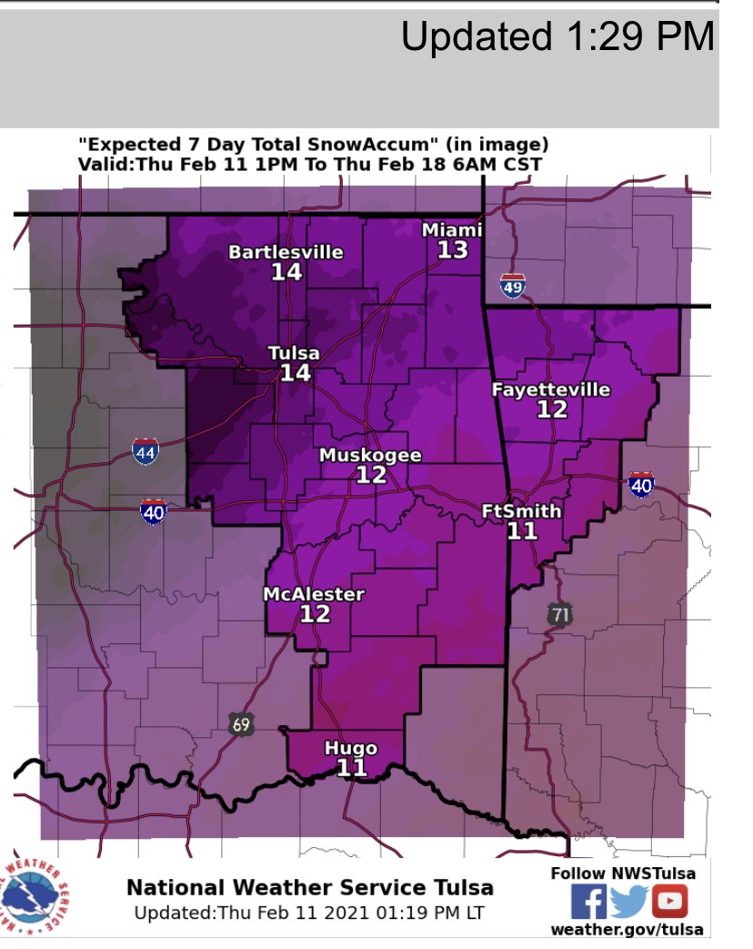
12z Euro coming in with heavy snow of 11-14 by Monday night.
Tulsa NWS chiclets page at 4.5 inches both Sunday and Monday for 9 total.
-
Tulsa NWS just expanded the WWA N to KS.
-
WINTER STORM WATCH IN EFFECT FROM WEDNESDAY MORNING THROUGH
THURSDAY MORNING...

* WHAT...Light freezing rain or drizzle thru tonight. Additional
  ice accumulations of less than a tenth of an inch. Freezing rain
  Wednesday. Ice accumulations of one tenth to four tenths of an
  inch possible.

* WHERE...Pittsburg, Haskell, Latimer and exclusively the higher
  terrain areas of northern Pushmataha and southern Le Flore
  Counties.

* WHEN...For the Winter Weather Advisory, until 6 AM CST
  Wednesday. For the Winter Storm Watch, from Wednesday morning
  through Thursday morning.

* IMPACTS...Sporadic power outages and tree damage are likely due
  to the ice. Travel could be very dangerous, especially on
-
Craig-Ottawa-Tulsa-Rogers-Mayes-Delaware-Creek-Okfuskee-Okmulgee-
Wagoner-Cherokee-Muskogee-McIntosh-
Including the cities of Vinita, Miami, Tulsa, Claremore, Pryor,
Grove, Jay, Sapulpa, Okemah, Okmulgee, Wagoner, Tahlequah,
Muskogee, and Checotah
208 PM CST Tue Feb 9 2021
...WINTER WEATHER ADVISORY IN EFFECT UNTIL 6 AM CST WEDNESDAY...
* WHAT...Mix of light snow and patchy freezing drizzle.
Additional snow accumulations of up to one inch and ice
accumulations of a light glaze.
* WHERE...Portions of east central, northeast and southeast
Oklahoma.
* WHEN...Until 6 AM CST Wednesday.
* IMPACTS...Untreated roads and bridges and overpasses may become
slick and hazardous overnight. -
8 minutes ago, StormChazer said:
Side roads still iced up good here in Owasso. Will have to go measure to see how much.
About .3 here.
-
1
-
-
40 minutes ago, JoMo said:
At least the cold air has deepened enough here to switch things to flurries.
I just noticed that here.
-
Tulsa NWS extended the WWA until midnight tonight.
-
I have .2 inch at my house on the trees.
-
1
-
-
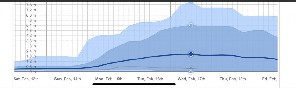
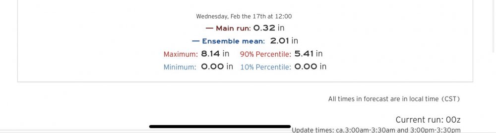
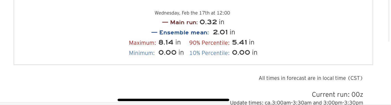
Euro ensemble with a broad range of snow amounts this weekend into next week.
-
11 minutes ago, WhiteoutWX said:
I’d basically just go with whatever the coldest model output is for the next several days (and even then might not be cold enough). Remains to be seen how the weekend plays out but still strong signals for some more extreme cold by Saturday/Sunday.
Yea,
Even the 06z GFS initialized 5-6 degrees too warm for Tulsa.
-
Schools closing this morning north of Tulsa, including Owasso.
My neighborhood between Owasso and Collinsville is SLICK!
-
3 minutes ago, NwWhiteOut said:
Not sure what will play out with all these freezing drizzle events, Tulsa popped a WWA up here late last night but nothing happened lol. Got one up tonight again, too warm yet again for anything here...34 degrees, will probly get to 33 once again lol. Guess we will see what happens with all this stuff and the better upcoming cold air
WWA was for N/NW of Tulsa until the afternoon.
I’ve seen some some reports from B-Ville about slicks roads up there.
The drizzle didn’t even freeze on vehicles despite it being 25/26 here.
-
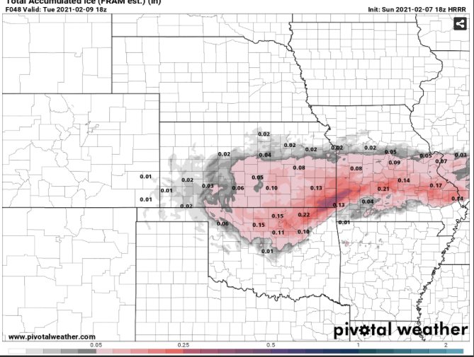
Interesting HRRR run for accumulating ice.
-
20 minutes ago, The Waterboy said:
00 NAM nowhere near what the 18z run was.
Really just fell in line with the other models.
Hoping for a surprise tomorrow!
-
-
LOL 18z GFS

MO/KS/AR/OK 2020-2021 "Winter" Discussion
in Central/Western States
Posted
18z NAM up from .9 to 1.5 for Tulsa at 00z Monday.
3.7 by 06z with more snow to go.
QPF for NC OK where the snow is ending at 06z is at .28 vs .33 on the 12z run.
Tulsa up from .07 to .28 though.