

CapturedNature
-
Posts
4,880 -
Joined
-
Last visited
Content Type
Profiles
Blogs
Forums
American Weather
Media Demo
Store
Gallery
Posts posted by CapturedNature
-
-
6 hours ago, Damage In Tolland said:
50’s and 60’s is cold?
When temps are 10 degrees below normal for highs, what do you call it?
-
Just noticed we were still using the winter thread so I create a spring one:
-
Just noticed we were still using the winter thread when it's nearly the middle of Spring!
-
20 minutes ago, Whineminster said:
Yup same here, sick. Hopefully not carrying nCoV-SARS-2 in the water droplets.
Virnado?
Pouring here...
-
 1
1
-
-
3 hours ago, Damage In Tolland said:
Greening and growing at 1k in the woods but apparently Chernobyl conditions along the E shore in burbs of BOS


If not tomorrow, that forsythia will probably bloom on Tuesday or Wednesday when the skies clear. Mine are slightly behind that but you run warmer than I do on average. 2012 bloomed on March 24th so you're running about a 7-8 days later than 2012. April 18th is the average date since 2002.
-
11 hours ago, Baroclinic Zone said:
Warm month
Yeah, my 7th warmest March so far. I'm not sure how the 4 majors are ranking.
-
31 minutes ago, weatherwiz said:
Does anyone know what the time period used is for the Daily Climate Reports? Is it 12:00 AM- 11:59 PM local time?
For the majors? I believe so. Most Coops though are 7a-7a.
-
25 minutes ago, Damage In Tolland said:
@The 4 Seasons 3.8”
Same here...
-
 1
1
-
-
19 minutes ago, Damage In Tolland said:
Have sleet and zr mix now at 30.6
Ice storm warning?
Same here...I measured 3.8-4.0 on the snowboard before the change over.
-
 1
1
-
-
What's this white stuff floating around? Is that the Korona?
-
1
-
-
52 minutes ago, snowman21 said:
70s and 80s across NYC area and NJ. Got warm quick with this late day sun.
Glad I don't live there. 61 here.
-
56 here...will I make it to 70?
-
Looks like a few hours of 2012 and then it's back to March 2020.
I saw some 70s south of NYC and 80s south of DC...even an 86 at one spot. Ouch! Glad we don't live there.
-
Accumulating snow...whoda thunk it? AEEK?
-
18 hours ago, Damage In Tolland said:
Amazing how green things are getting and what is growing. Even here forsythia are about to pop and already have in valley. Crazy early for all this. Ginx wants pics he got em
My forsythia are certainly not about to pop. The cooler weather the next few days will slow that process. I commented the other day that I saw a single forsythia in full bloom but other forsythia's on the same street didn't even have buds, just like mine. I think those are different cultivars. I'm still planning on going by the same forsythia bushes that I've been using for nearly 20 years to keep things relative and they are not about to pop.
-
17 hours ago, Cold Miser said:
Full leaf out by the end of April?
Kevin considers full leaf out when the tips of the leaf are about 1mm out of it's bud on one tree so that could happen in March!
-
38 minutes ago, Typhoon Tip said:
Well... I didn't say 'average' in terms of total - but yeah, 10 years
Correct, by you did say 7 out of 10 have been in March and my date is well into April which prompted my question wondering if the cultivar that you have is the same one I saw in bloom yesterday. Nothing else is even close here so yeah, just wondering or making an interesting observation.
-
3 minutes ago, Typhoon Tip said:
In the last 10 years I've owned this property I've seen March 'sythia buds 7 times
It's interesting that your average bloom date is in March. I was driving through one street and I was shocked to see one in the valley that had flowers yesterday. The thing is that none of the others in the area did or even had bud swelling. It's either an outlier or a different cultivar from everything else in the area. My average bloom time since 2002 is 4/18 so I'm wondering if you have the same cultivar. Do other forsythias in the area bloom at the same time?
-
13 minutes ago, Damage In Tolland said:
From mid week into weekend it’s 65-70 next week. Even if Sunday and Monday come out normal. We’ll add to it next week
Why would you think that they are cumulative?
Let's say you have 10 days that are +10 departure. That's an average of +10. If the next 5 are 0, you now have 15 days or 100/15 which is now +6. If you have another 10 days of +10 you now have 25 days or 200/25 which is 8. Add in another 5 days at 0 and you have 30 days or 200/30 and an average temp of +6.6. So even if most of the month is +10 which as Will stated is hard to maintain, you're not averaging +10 for the month to make it warmer than 2012.
-
5 minutes ago, Damage In Tolland said:
Yes. This will be 2nd or maybe 3rd warmest Morch on record in SNE. I’m not sure how one could even debate that ?
Because it hasn't happened yet?
-
1
-
 1
1
-
-
38 minutes ago, Typhoon Tip said:
Since the comparison seems to be > than meaningless after all...
Here's 2012 March, ( https://www.ncdc.noaa.gov/sotc/national/201203): ... I did a spot look up on Hartford, CT for that month and they eye-popped a +9.6 above average monthly mean.
Contrasting, as of 1/3 of the present 2020 March in the books, Hartford is averaging +9.9
Now... prognostics would argue we settle off this largely impressive departure as some of these over-top anticyclones move rapidly through a general vestigial progressive flow bias that is unrelentingly the entire Hemispheric character that won't apparently die without actually destroying the planet apparently .. eh hm... And that's a cold source at low levels (off-set by equinotical sun angles). After that, we probably add back, but by weight of numbers it would be slower and take more to get back to 9.9 if a return to that value could/would take place... That's extraordinarily large - that value right there, and even though CC and blah blah blah...that's really just so far over the top that's something else entirely driving that - obviously...
Meantime, ORH is +10.3 on the NWS' climate interfacing ...and yes people want to quibble over decimal handling ...but the 10 in front of the "." negates your denial tactic so forget that noise.
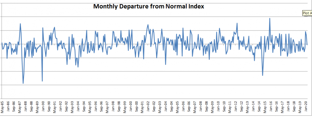
I calculate something I call the Departure from Normal Index. It's basically accumulation of the daily departures but it allows you to see how anomalous a month is. The highest or lowest peaks are #1 or 2 in their respective months. You can see that March 2012 was a standout. It should be interesting to see how this month racks up when all is said and done.
-
3 minutes ago, Damage In Tolland said:
Sat look like 50ish. Sunday likely cooler than normal 40-45. Then retorch next week with 60’s near 70 middle/ end of week
Good luck with hitting 50° at your place on Saturday. My point is that every day is not going to be a massive departure like the past couple of days. As it stands I'm currently at #7 so this month if we're counting our chickens on the 11th needs to go through a lot of cousins to reach sisterhood.
-
9 minutes ago, Damage In Tolland said:
They laughed when we said #2. Sister of 2012. They aren’t laughing anymore. Or posting
When I look at my top 10 warmest March's, 2012 is on top of course but the next 4 aren't even 2002. 2010, 2000, 2016 and 1991 all come next. This week has had a few warm days but things look more normal by this weekend.
-
14 minutes ago, Minenfeld! said:
I can take some pictures of the area around the office today in Stamford if it's needed. There is a tree now with little dark red buds. There's no doubt we'll be ahead of schedule by several weeks this year.
Yes, we are a few weeks ahead of where we normally are. The earliest my forsythia's have been in bloom is 3/24 in 2012 and 3/31 in 2002. My average date is 4/18 so when they bloom we'll know how far we are ahead. That's the only date I track on my weather record but I also have records from my maple sugaring. I always tap the weekend after valentines day and my season ends at the end of March. I'm still collecting sap and this weekend looks like we'll have ideal weather (40s/20s) for several days so I'll be collecting into next week and that also points to us being about 1-2 weeks ahead of where we normally are.

Fear and loathing April, 2020 discussion, obs, and the occasional derailment
in New England
Posted
When are we getting 80s?
What do you call 50s in the summer?