

CNY-LES FREAK
-
Posts
3,144 -
Joined
-
Last visited
Content Type
Profiles
Blogs
Forums
American Weather
Media Demo
Store
Gallery
Everything posted by CNY-LES FREAK
-

Upstate/Eastern New York
CNY-LES FREAK replied to BuffaloWeather's topic in Upstate New York/Pennsylvania
Maybe Mt Washington, RLMAO -
Upstate/Eastern New York
CNY-LES FREAK replied to BuffaloWeather's topic in Upstate New York/Pennsylvania
Just glad I have off tomorrow from work! -
Upstate/Eastern New York
CNY-LES FREAK replied to BuffaloWeather's topic in Upstate New York/Pennsylvania
You can see the convergence occurring within the band as the winds are due West across the South shore while over the lake the winds are N-NW, which is definitely fueling this beast of a band. The best part is that theres absolutely no wind at all as its just falling straight down and accumulating very fast and efficiently! Flake size is just awesome as well. We did have some graupel at the beginning but that quickly went over to heavy snow as the heavier returns started to show up! -
Upstate/Eastern New York
CNY-LES FREAK replied to BuffaloWeather's topic in Upstate New York/Pennsylvania
It sure does mean business and its not moving yet! -
Upstate/Eastern New York
CNY-LES FREAK replied to BuffaloWeather's topic in Upstate New York/Pennsylvania
Last time I seen a steady state WNW band such as this one was earlier this yr when it stayed mostly rain but if it were snow we would of gotten clobbered like we are right now! -
Upstate/Eastern New York
CNY-LES FREAK replied to BuffaloWeather's topic in Upstate New York/Pennsylvania
Yeah well the 3K, WRF and the HRRR were all dead wrong, lol! -
Upstate/Eastern New York
CNY-LES FREAK replied to BuffaloWeather's topic in Upstate New York/Pennsylvania
I'll take a measurement in the AM when the band settles to my South and effects Syracuse proper! -
Upstate/Eastern New York
CNY-LES FREAK replied to BuffaloWeather's topic in Upstate New York/Pennsylvania
We've been upgraded to a warning and its definitely warranted! .LAKE EFFECT SNOW WARNING IN EFFECT UNTIL NOON EST TODAY... * WHAT...Heavy lake effect snow. Additional snow accumulations of 6 to 9 inches in the most persistent lake snows. * WHERE...Oswego county. The heaviest snow will be across the southern portion of the county. * WHEN...Until noon EST today. * IMPACTS...Travel will be very difficult with poor visibility and deep snow cover on roads. The hazardous conditions will impact the morning commute. PRECAUTIONARY/PREPAREDNESS ACTIONS... Heavy snow will fall in relatively narrow bands. If traveling, be prepared for rapidly changing road conditions and visibilities. Submit snow reports through our website or social media. I still think totals will surpass the 9" mark as I'm already at 8" like I said! -
Upstate/Eastern New York
CNY-LES FREAK replied to BuffaloWeather's topic in Upstate New York/Pennsylvania
Tug, hopefully this will sag southward in the next few hrs and clobber you for a few hrs but who knows with these WNW bands as they are very anomalous to say the least! -
Upstate/Eastern New York
CNY-LES FREAK replied to BuffaloWeather's topic in Upstate New York/Pennsylvania
It has to be snowing at least 2-3"/hr right now and has been for a couple hrs now! Just measured at 3AM and I'm at 8" with the band still cranking so I believe this will be an overachiever and we will easily surpass the 1' mark when its all said and done. I was NOT expecting this to occur but am super happy that it is so there wont be anymore complaining out of me for at least until our next rain storm, lol! The band looks to be steady state out of the WNW with no signs of moving as of yet but am expecting it to start sagging South in the next couple hours! CONGRATS TO ME, LOL!!!!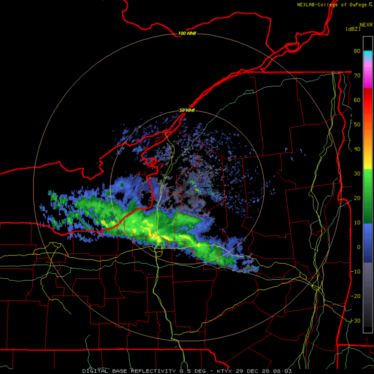
-
Upstate/Eastern New York
CNY-LES FREAK replied to BuffaloWeather's topic in Upstate New York/Pennsylvania
This is not an ideal sounding for heavy LES Now this is an amazing sounding but look at the mean wind flow 260, once again, congrats Wolfie, lol! -
Upstate/Eastern New York
CNY-LES FREAK replied to BuffaloWeather's topic in Upstate New York/Pennsylvania
I'm expecting less than 3" of snow and Im smack dab in the middle of where they say the band will end up. I will say the set-up is definitely ideal with a steady WNW flow for about 6-8 hrs which can drop several inches if it materializes the way they say it will but with the way things have gone so far, i'll stay cautiously optimistic! -
Upstate/Eastern New York
CNY-LES FREAK replied to BuffaloWeather's topic in Upstate New York/Pennsylvania
Looks like the wind shift is approaching the middle of Lake Ontario and racing eastward!
-
Upstate/Eastern New York
CNY-LES FREAK replied to BuffaloWeather's topic in Upstate New York/Pennsylvania
LEK is gonna jackpot with tonight's flurries, lol, as I bet he ends up with close to 6" -
Upstate/Eastern New York
CNY-LES FREAK replied to BuffaloWeather's topic in Upstate New York/Pennsylvania
Um, I don't think that was me whining by saying I suddenly live in a snow hole and I can't wait to move, lol! You do nothing but whine even when its snowing, lol! -
Upstate/Eastern New York
CNY-LES FREAK replied to BuffaloWeather's topic in Upstate New York/Pennsylvania
I can't wait to move away from this snow hole that I live in. I knew when I purchased this house in 2008 that we were buying in a wicked transition zone and I was definitely right, but at least back then we nickel and dimed our way to average, but we cant even do that anymore or so it seems! -
Upstate/Eastern New York
CNY-LES FREAK replied to BuffaloWeather's topic in Upstate New York/Pennsylvania
Look at the second frame and you see where the band splits, thats exactly where I live, lol, so thats exactly what I'm expecting to happen cause it happens that way every event and I wouldn't even call this an event! -
Upstate/Eastern New York
CNY-LES FREAK replied to BuffaloWeather's topic in Upstate New York/Pennsylvania
Why we even taking a model run verbatim? Sent from my SM-G970U using Tapatalk -
Upstate/Eastern New York
CNY-LES FREAK replied to BuffaloWeather's topic in Upstate New York/Pennsylvania
I'm not even tracking anymore this season as its absolutely pointless! -
Upstate/Eastern New York
CNY-LES FREAK replied to BuffaloWeather's topic in Upstate New York/Pennsylvania
Yeah, and the totals were lowered each time, lol, as the 12Z has me getting 1". Like I said, its just not gonna happen at least for my area, but your area, as usual is a lock for some kind of accumulation so congrats bro! -
Upstate/Eastern New York
CNY-LES FREAK replied to BuffaloWeather's topic in Upstate New York/Pennsylvania
/O.NEW.KBUF.WW.Y.0028.201228T1200Z-201229T2100Z/ Oswego- Including the city of Oswego 346 AM EST Mon Dec 28 2020 ...WINTER WEATHER ADVISORY IN EFFECT FROM 7 AM THIS MORNING TO 4 PM EST TUESDAY... * WHAT...Snow expected. Total snow accumulations of 4 to 6 inches across the Tug Hill Plateau, and 3 to 5 inches across lower elevations in the most persistent lake snows. * WHERE...Oswego county. Accumulating snow today through this evening will be confined mainly to the Tug Hill Plateau. Lake effect snow later tonight through Tuesday will be mainly in the central and southern portion of the county. * WHEN...From 7 AM this morning to 4 PM EST Tuesday. * IMPACTS...Plan on snow covered and slippery road conditions. The hazardous conditions will impact the morning and evening commute. PRECAUTIONARY/PREPAREDNESS ACTIONS... Periods of snow will result in snow covered roads and limited visibilities. Slow down and use caution while driving. Submit snow reports through our website or social media. KBGM ..WINTER WEATHER ADVISORY IN EFFECT FROM 9 PM THIS EVENING TO 4 PM EST TUESDAY... * WHAT...Snow expected. Total snow accumulations of 3 to 6 inches. * WHERE...Onondaga, Madison and Southern Oneida counties. * WHEN...From 9 PM this evening to 4 PM EST Tuesday. * IMPACTS...Plan on slippery road conditions. The hazardous conditions could impact the morning commute Tuesday. * ADDITIONAL DETAILS...A lake effect snow band will set up east of Lake Ontario late this evening, move south through the Thruway corridor from Syracuse to Utica late tonight and Tuesday morning, then into areas south of Syracuse Tuesday morning into the early afternoon. This band will have snowfall rates of 1 to 2 inches per hour at times between 4 am and 10 am. We'll see how all of this turns out! -
Upstate/Eastern New York
CNY-LES FREAK replied to BuffaloWeather's topic in Upstate New York/Pennsylvania
very true BW -
Upstate/Eastern New York
CNY-LES FREAK replied to BuffaloWeather's topic in Upstate New York/Pennsylvania
Them is garbage, actually they're all garbage when it comes to lake effect so I don't even know why people look at models when it comes to lake effect because they're all wrong in the end Sent from my SM-G970U using Tapatalk -
Upstate/Eastern New York
CNY-LES FREAK replied to BuffaloWeather's topic in Upstate New York/Pennsylvania
That band is transient it's not a steady band it's just going to drop south so the most we're going to get out of that band is maybe 2 in if that Sent from my SM-G970U using Tapatalk -
Upstate/Eastern New York
CNY-LES FREAK replied to BuffaloWeather's topic in Upstate New York/Pennsylvania
Once again bro you seriously need to move to Florida or something Sent from my SM-G970U using Tapatalk


